
Marine Science News 2021
From enormous tides to millions of shells, here are 6 unique beaches for your summer road trip
As lockdowns ease and we head into summer, many Australians have started thinking about their beach holiday. For most people, a beach involves sun, sand, salt, and waves. A beach is a beach – right?
For coastal scientists and engineers, it’s a little different. We wonder how these beaches are made and why they are so different.
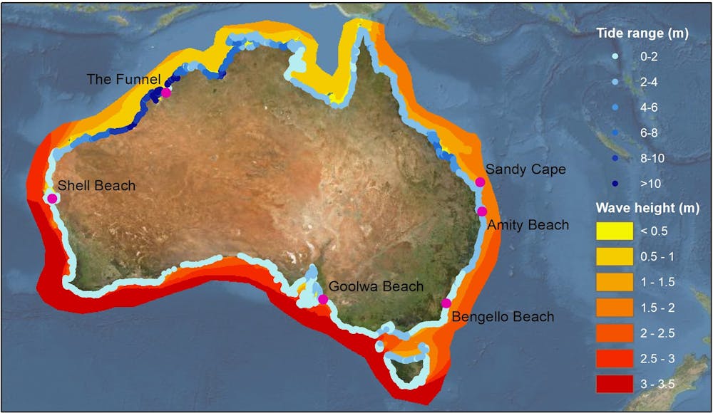
Australia has over 35,000 kilometres of coastline to explore, and our beaches can differ radically. In Australia’s south, where tides are smaller and waves bigger, we get high energy beaches with lots of surf and sand. The north’s larger tides and smaller waves mean the beaches look quite different – they’re flatter, with big intertidal zones. Some even have mud instead of sand.
To pique your interest, here are six beaches from around the country with special characteristics, all well worth exploring on your summer road trip or beach holiday.
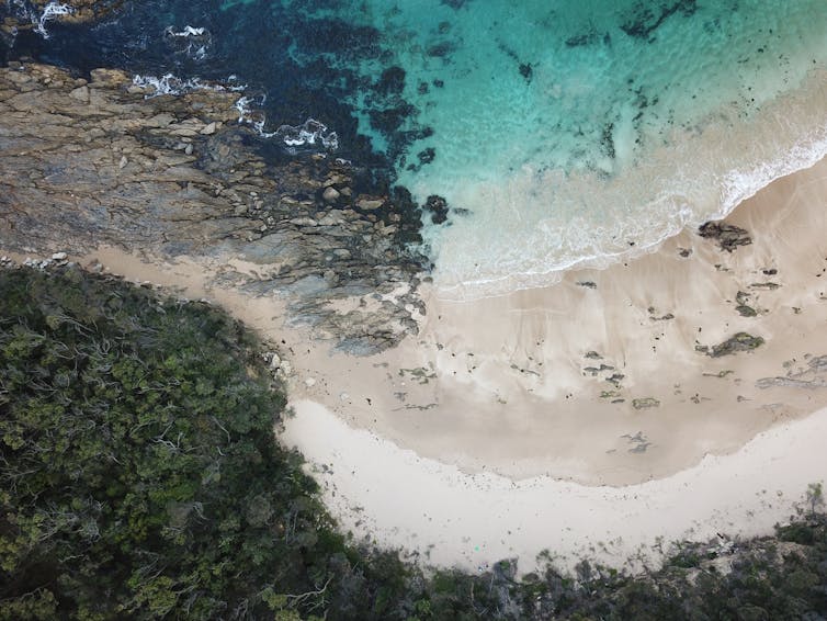
1. Sandy Cape – end of the line for the sand islands
K’gari (Fraser Island), Queensland.
Waves and storms along the east coast, from the New South Wales/Victoria border to K'Gari in Queensland, usually come from the south and southeast. This drives longshore sediment transport, a process where sand is moved up the coast by waves and wave-driven currents.
As the sand moves along the NSW coast and into Queensland, it beach-hops its way north, encountering natural barriers like headlands as well as human barriers such as breakwaters. Sand will often skirt these barriers in pulses, as tends to happen at Byron Bay.
As the coast turns to the west in southeast Queensland, the sand keeps getting pushed north. That’s how Australia got the largest sand islands in the world: Minjerribah (South and North Stradbroke), Mulgumpin (Moreton), Yarun (Bribie), and finally K’gari.
The northernmost point of K’gari, Sandy Point, marks where the sand heads underwater, moving along the continental shelf before dropping off the edge and sliding down the slope into the deep abyssal plains.
If you make it to this beach, you can see sand being swirled away into deeper water – the very end of the above-water part of the cycle.
2. The Funnel – the biggest tides in Australia
Collier Bay, Western Australia
The Kimberley region of Australia is home to the biggest tides in the country. Unfortunately, there aren’t many tide gauges in this area, with over 1,000km between instruments in places. So, to find the beach with the biggest tides, we either have to collect more data or use a computer model.
When we model the tides for every Australian beach, The Funnel in Collier Bay comes out as the beach with the biggest tides. Its range is a whopping 13.5 metres!
Getting to this beach might be tricky as you’ll need to arrive by boat. But it would be worth the trip, as the beach at high tide is composed of cobbles and likely sand and mud at low tide. Watching the tide roar in would be something to see – just watch out for crocs!
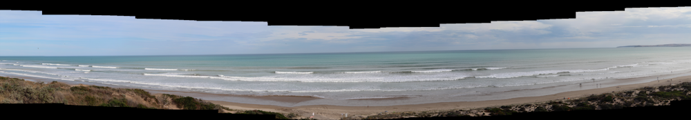
3. Goolwa Beach – the high energy beach
South Australia
When rivers as big as the Murray – whose basin covers one-seventh of mainland Australia – meet the ocean, they normally form huge deltas like the Mississippi or the Nile.
But because of Australia’s age, low rainfall and water extraction for agriculture, the Murray-Darling Basin only delivers a relatively small amount of water and sediment to the coast. So instead of a classic river delta at the end of the Murray, unusually, we have a beach system.
Goolwa Beach is part of this system, its fine sands representing the last barrier to the mighty Murray River on its journey to the ocean. The beach is also exposed to the huge waves rolling in from the Southern Ocean. That makes it one of our highest energy beaches – so much so it’s the archetype of the high energy beach type called “dissipative” in our Australian beach classification system.
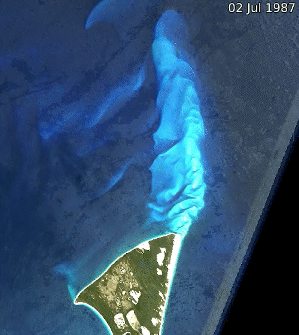
4. Amity Beach – the beach with sinkholes
Minjerribah, Queensland
The islands of Minjerribah (North Stradbroke) and Mulgumpin (Moreton) form the barrier separating Moreton Bay near Brisbane from the Coral Sea. Between them lies Rainbow Channel through which the tide flows in and out of Moreton Bay.
These fast tidal currents cause large amounts of sand to form shifting sand shoals on both the ocean and bay sides of the channel.
Amity Beach sits on the edge of this channel and the constantly changing dynamics of this system cause “sinkholes” to occur regularly on this beach. Rainbow Beach near K'Gari is better known due to its habit of swallowing cars, but Amity Beach is unique. Why? Because the sinkholes always occur in the same place.
That makes it the only place in the world where scientists and engineers can reliably observe this amazing phenomenon to work out why sinkholes occur and how they work.
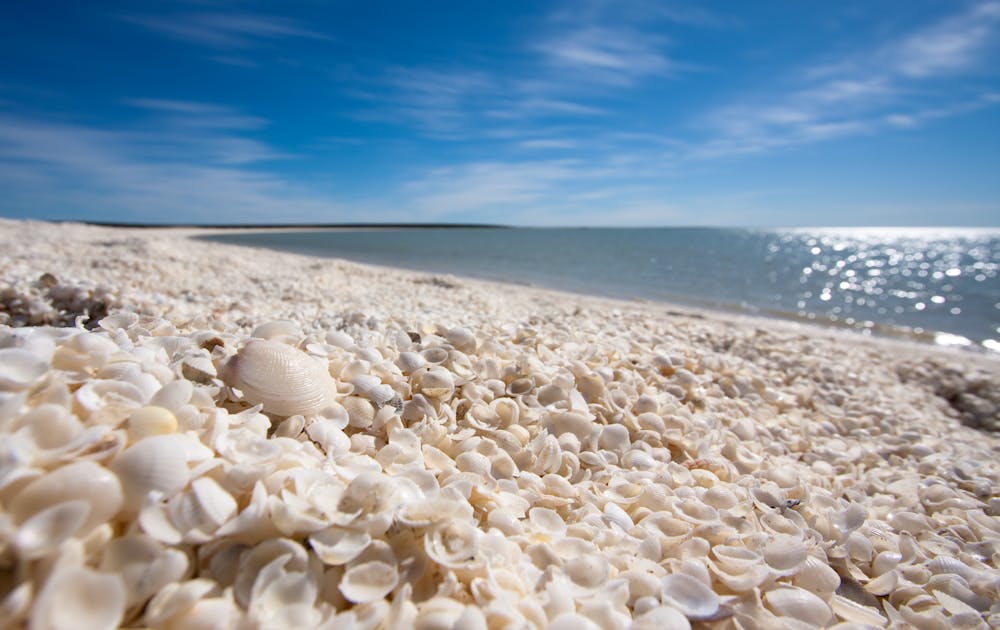
5. Shell Beach – walk on millions of shells
Shark Bay, Western Australia
Most of us tend to think of beaches as being made up by sand, but they don’t have to be. Beaches can be made of mud or cobbles or even just shells.
Shell Beach in Shark Bay is a rarity as it’s almost entirely made up of trillions of shells, with the piles up to 10m deep.
These shells all come from one mollusc, the Fragum cockle. The reason there are so many of these shells is because the waters of Shark Bay are saltier than the ocean.
This hypersaline environment makes it hard for most species to survive. That means the Fragum cockle has very few competitors or predators and can proliferate. Just remember to bring some footwear!
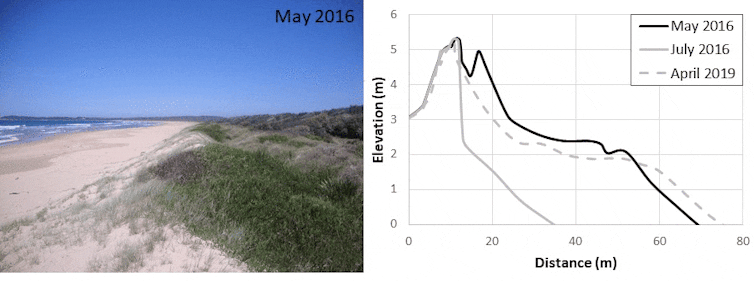
6. Bengello Beach – a time capsule made of sand
New South Wales
Coastal scientists and engineers love data about beaches, and especially long-term records of how much sand is on a beach.
Bengello Beach in southern NSW represents the longest record of beach surveys in Australia with measurements every 2-6 weeks since January 1972.
These measurements have captured beach erosion during storms and its subsequent recovery. Data like this underpins models forecasting how our beaches will respond to climate change.
Bengello is also a living snapshot of beach evolution, capturing the way many of Australia’s beaches have changed since sea level stabilised at about today’s level after the last ice age.
If you walk from the road to the beach, you pass over ridges of ancient sand dunes. These formed as the beach slowly built out towards the sea over the last 6,000 years, as waves and currents piled up more and more sand on the beach.
When road-tripping to Australia’s beaches, remember to check local weather and marine forecasts to make sure it’s safe to swim and leave only your footprints behind. And if you make it to any of
these beaches, why not share your knowledge about their significance with your travel buddies?![]()
Hannah Power, Associate Professor in Coastal and Marine Science, University of Newcastle
This article is republished from The Conversation under a Creative Commons license. Read the original article.
23 December 2021
La Niña just raised sea levels in the western Pacific by up to 20cm. This height will be normal by 2050
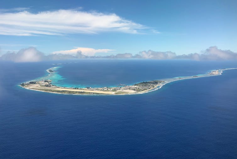
Severe coastal flooding inundated islands and atolls across the western equatorial Pacific last week, with widespread damage to buildings and food crops in the Federated States of Micronesia, Marshall Islands, Papua New Guinea and Solomon Islands.
On one level, very high tides are normal at this time of year in the western Pacific, and are known as “spring tides”. But why is the damage so bad this time? The primary reason is these nations are enduring a flooding trifecta: a combination of spring tides, climate change and La Niña. La Niña is a natural climate phenomenon over the Pacific Ocean known for bringing wet weather, including in eastern Australia. A less-known impact is that La Niña also raises sea levels in the western tropical Pacific. In a terrifying glimpse of things to come, this current La Niña is raising sea levels by 15-20 centimetres in some western Pacific regions – the same sea level rise projected to occur globally by 2050, regardless of how much we cut global emissions between now and then. So let’s look at this phenomena in more detail, and why we can expect more flooding over the summer.
These spring tides aren’t unusual
Low-lying islands in the Pacific are considered the frontline of climate change, where sea level rise poses an existential threat that could force millions of people to find new homes in the coming decades.
Last week’s tidal floods show what will be the new normal by 2050. In the Marshall Islands, for example, waves were washing over boulder barriers, causing flooding on roads half a metre deep.
This flooding has coincided with the recent spring tides. But while there is year to year variability in the magnitude of these tides that vary from location to location, this year’s spring tides aren’t actually unusually higher than those seen in previous years.
For instance, tidal analysis shows annual maximum sea levels at stations in Lombrom (Manus, Papua New Guinea) and Dekehtik (Pohnpei, Federated States of Micronesia) are roughly 1-3cm higher than last year. Meanwhile, those at Betio (Tarawa, Kiribati) and Uliga (Majuro, Marshall Islands) are roughly 3-6cm lower.
This means the combined impacts of sea level rise from climate change and the ongoing La Niña event are largely responsible for this year’s increased flooding.
A double whammy
The latest assessment report from the Intergovernmental Panel on Climate Change finds global average sea levels rose by about 20cm between 1901 and 2018.
This sea level rise would, of course, lead to more coastal inundation in low-lying regions during spring tides, like those in the western tropical Pacific. However, sea level rise increases at a relatively small rate – around 3 millimetres per year. So while this can create large differences over decades and longer, year to year differences are small.
This means while global mean sea level rise has likely contributed to last week’s floods, there is relatively small differences between this year and the previous few years.
This is where La Niña makes a crucial difference. We know La Nina events impact the climate of nations across the Pacific, bringing an increased chance of high rainfall and tropical cyclone landfall in some locations.
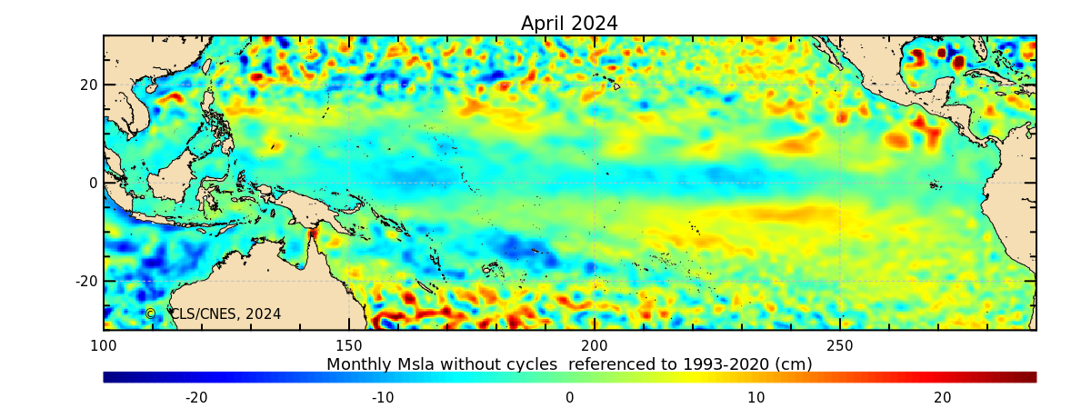
But the easterly trade winds, which blow across the Pacific Ocean from east to west, are stronger in La Niña years. This leads to a larger build up of warm water in the western Pacific.
Warm water is generally thicker than cool water (due to thermal expansion), meaning the high heat in the western equatorial Pacific and Indonesian Seas during La Niña events is often accompanied by higher sea levels.
This year is certainly no different, as can be seen in sea surface height anomaly maps here and here.
From these maps, along with past studies, it’s clear Pacific islands west of the date line (180⁰E) and between Fiji and the Marshall Islands (15⁰N-15⁰S) are those most at risk of high sea levels during La Niña events.
What could the future hold?
We can expect to see more coastal flooding for these western Pacific islands and atolls over the coming summer months. This is because the La Niña-induced sea level rise is normally maintained throughout this period, along with more periods with high spring tides.
Interestingly, the high sea levels related to La Niña events in the northern hemisphere tend to peak in November-December, while they do not peak in the southern hemisphere until the following February-March.
This means many western Pacific locations on both sides of the equator will experience further coastal inundation in the short term. But the severity of these impacts is likely to increase in the southern hemisphere (such as the Solomon islands, Tuvalu and Samoa) and decrease in the northern hemisphere (such as the Marshall Islands and the Federated States of Micronesia).
Looking forward towards 2050, a further 15-25cm of global average sea level rise is expected. La Niña events typically cause sea levels in these regions to rise 10-15cm above average, though some regions can bring sea levels up to 20cm.
Given the projected sea level rise in 2050 is similar to the La Niña-induced rise in the western Pacific, this current event provides an important insight into what will become “normal” inundation during spring tides.
Unfortunately, climate projections show this level of sea level rise by 2050 is all but locked in, largely due to the greenhouse gas emissions we’ve already released.
Beyond 2050, we know sea levels will continue to rise for the next several centuries, and this will largely depend on our future emissions. To give low-lying island nations a fighting
chance at surviving the coming floods, all nations (including Australia) must drastically and urgently cut emissions.
![]()
Shayne McGregor, Associate Professor, and Associate Investigator for the ARC Centre of Excellence for Climate Extremes, Monash University
This article is republished from The Conversation under a Creative Commons license. Read the original article.
Dec 16 2021
Movement of plankton between tropical marine ecosystems drives 'sweet spots' for fishing
A new analysis suggests that the movement of plankton and plankton-eating fish play a central role in driving local spikes of extreme biological productivity in tropical coral reefs, creating "sweet spots" of abundant fish. Renato Morais of James Cook University in Townsville, Australia, and colleagues present these findings in a study publishing November 2nd in the open-access journal PLOS Biology.

Although some ecosystems are limited by their intrinsic productivity (from photosynthesis, for example), previous research has shown that mobile resources like plankton can serve as vectors that transfer energy and nutrients from offshore ecosystems to coral reef ecosystems. Such transfers of resources between ecosystems are known as spatial subsidies, and they enable ecosystems to surpass the limits of their intrinsic capabilities for biological productivity, resulting in more abundant life. However, the extent to which the movement of plankton and plankton-eating fish boost abundance in tropical marine ecosystems has been unclear.
To help clarify and quantify this role, Morais and colleagues integrated and analyzed extensive data from visual fish counts. One dataset covered the tropical waters of the Indian Ocean and much of the Pacific, while the other fish count data came from three specific tropical locations that were representative of the diversity of coral reef ecosystems found in the larger dataset. The analysis revealed that plankton-eating fish do indeed play a major, widespread role as vectors of spatial subsidies to tropical coral reefs. By feeding on offshore plankton, they deliver extra resources to reef ecosystems and thereby drive local periods of extreme biological productivity—including for their own predators. In these "sweet spots," plankton-eating fish are responsible for more than 50 percent of the total fish production, and people might find conditions there optimal for bountiful fishing.
The researchers note that their findings hold particular significance for the future of tropical reef fisheries. Coral reefs continue to degrade, and offshore productivity is expected to decline, so sweet spots that concentrate these dwindling resources may increase in importance for fishers. Morais adds, "How do tropical oceans sustain high production and intense coastal fisheries despite occurring in nutrient-poor oceans? Spatial subsidies vectored by planktivorous fishes dramatically increase local reef fish biomass production, creating 'sweet spots' of fish concentration. By harvesting oceanic productivity, planktivorous fishes bypass spatial constraints imposed by local primary productivity, creating 'oases' of tropical marine biomass production."
Original article: Morais RA, Siqueira AC, Smallhorn-West PF, Bellwood DR (2021) Spatial subsidies drive sweet spots of tropical marine biomass production. PLoS Biol 19(11): e3001435. doi.org/10.1371/journal.pbio.3001435
Nov 10 2021
White sharks can easily mistake swimmers or surfers for seals. Our research aims to reduce the risk
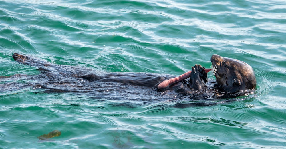
Meet the penis worm: don’t look away, these widespread yet understudied sea creatures deserve your love
Am I not pretty enough? This article is part of The Conversation’s series introducing you to unloved Australian animals that need our help.
Australia’s oceans are home to a startling array of biodiversity — whales, dolphins, dugongs and more. But not all components of Aussie marine life are the charismatic sort of animal that can feature in a tourism promotion, documentary, or conservation campaign.
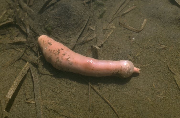
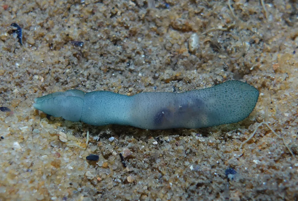
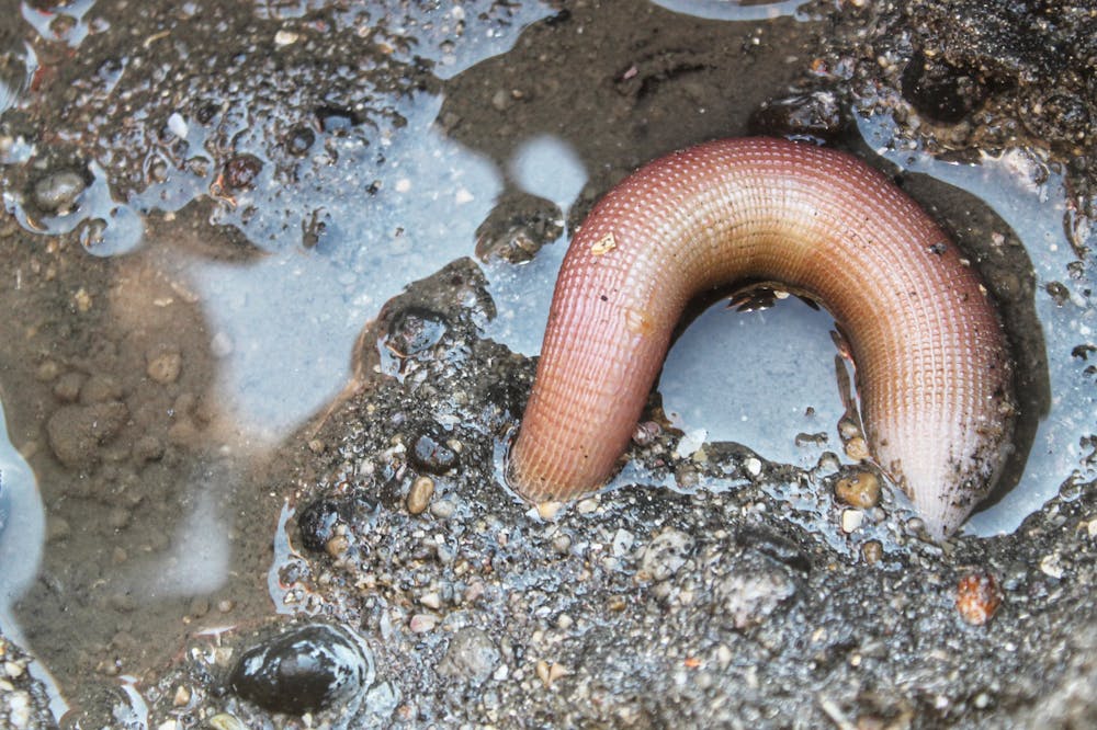
The echiuran, or spoon worm, is one such animal. It is also called the penis worm.
There is no “Save the Echiuran Foundation” and no influencers selling merchandise to help save them. But these phallic invertebrates are certainly worth your time as integral and fascinating members — of Australia’s marine ecosystems.
What makes them so interesting?
Taxonomists have classified echiurans in various different ways over the years, including as their own group of unique animals. Today, they’re considered a group of annelid worms that lost their segmentation. There is uncertainty about the exact number of species, but an estimate is 236.
The largest echiuran species reach over two metres in length! They have a sausage-shaped muscular trunk and an extensible proboscis (or tongue) at their front end. The trunk moves by wave like contractions.
Most echiurans live in marine sand and mud in long, U-shaped burrows, but some species also live between rocks. And they’re widespread, living up to 6,000 metres deep in the ocean all the way to the seashore, worldwide.
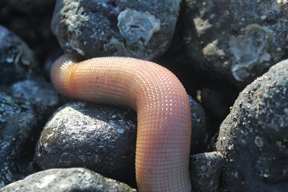
For example, one species, Ochetostoma australiense, is a common sight along sandy or muddy shorelines of Queensland and New South Wales, where it sweeps out of its burrow to collect and consume organic matter.
In fact, their feeding activities are something to behold, as they form a star-like pattern on the surface that extends from their burrow opening.
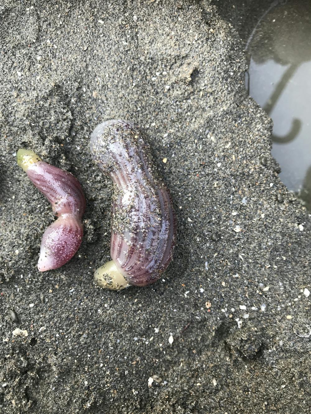
In another species, Bonella viridis, there is a striking difference> between the males and females — the females are large (about 15 centimetres long) and the males are tiny (1-3 millimetres). Most larvae are sexually undifferentiated, and the sex they end up as depends on who’s around. The larvae metamorphose into dwarf males when they’re exposed to females, and into females when there are no other females present.
Males function as little more than a gonad and are reliant on females for all their needs.
Why they’re so important
Echiurans perform a range of important ecological functions in the marine environment. They’re known as “ecosystem engineers” - organisms that directly or indirectly control the availability of resources, such as food and shelter, to other species. They do this mainly by changing the physical characteristics of habitats, for example, by creating and maintaining burrows, which can benefit other species.
Echiurans also have a variety of symbiotic animals, including crustaceans and bivalve molluscs, residing in their burrows. This means both animals have a mutually beneficial relationship. In fact, animals from at least eight different animal groups associate with echiuran burrows or rock-inhabiting echiurans — and this is probably an underestimate.
They’re beneficial for humans, too. Their burrowing and feeding habits aerate and rework sediments. Off the Californian coastline, for example, scientists noted how these activities reduced the impacts of wastewater on the seabed.
And they’re an important part of the such as the houndsharks, and species of commercial significance such as Alaskan plaice. Some mammals feast on them, too, such as the in the Bering Sea, and the southern sea otter. In Queensland they also contribute to the diet of the critically endangered eastern curlew.
And many people eat them in East and Southeast Asia, where they’re chopped up and eaten raw, or used as a fermented product called gaebul-jeot. They (allegedly) taste slightly salty with sweet undertones.
The unloved billions
In Australia there is very little known about the biology and ecological roles of our echiuran fauna. This can also be said of many of Australia’s soft sediment marine invertebrates — the unloved billions.
We simply do not understand the population dynamics of even the large and relatively common echiuran species, and the human processes that threaten them. Given their role as ecosystem engineers, impacts to echiuran populations can flow on to other components of the seabed fauna, imperilling entire ecosystems.
We can, in general terms, predict that populations have suffered from the cumulative effects of urbanisation and coastal development. This includes loss and modification of habitats, and changes to water quality.
Populations may also be harmed by undersea seismic activities used in oil and gas exploration, but this is still poorly understood. Until recently, scientists knew only of the threats seismic activity posed to the hearing of whales and dolphins. It’s becoming clearer they can also affect the planet’s vital invertebrate species.
It is a dilemma for marine conservation when so little is known about a species that impacts cannot be reliably predicted, and where there is little or no impetus to improve this knowledge base.
We cannot simply presume an animal does not play an important role in an ecosystem because it lacks charisma.
In George Orwell’s novel Animal Farm, it was said “All animals are equal but some animals are more equal than others”. This remains abundantly true in terms of how humans view animals. But we must move away from this philosophy if we are to conserve and restore the planet’s fragile ecosystems.
Daryl McPhee, Associate Professor of Environmental Science, Bond University
This article is republished from The Conversation under a Creative Commons license. Read the original article.
August 18 2021
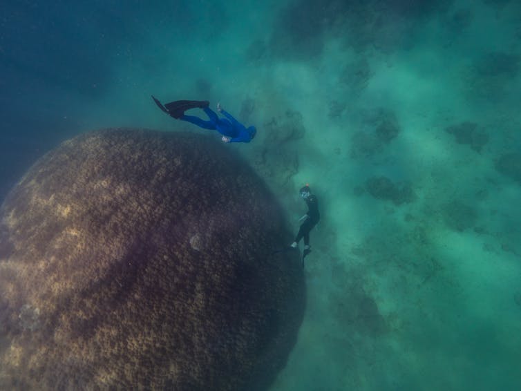
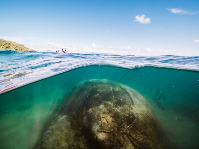
Snorkelers discover rare, giant 400-year-old coral – one of the oldest on the Great Barrier Reef
Snorkellers on the Great Barrier Reef have discovered a huge coral more than 400 years old which is thought to have survived 80 major cyclones, numerous coral bleaching events and centuries of exposure to other threats. We describe the discovery in research published today.
Our team surveyed the hemispherical structure, which comprises small marine animals and calcium carbonate, and found it’s the Great Barrier Reef’s widest coral, and one of the oldest.
It was discovered off the coast of Goolboodi (Orpheus Island), part of Queensland’s Palm Island Group. Traditional custodians of the region, the Manbarra people, have called the structure Muga dhambi, meaning “big coral”.
For now, Muga dhambi is in relatively good health. But climate change, declining water quality and other threats are taking a toll on the Great Barrier Reef. Scientists, Traditional Owners and others must keep a close eye on this remarkable, resilient structure to ensure it is preserved for future generations.
Far older than European settlement
Muga dhambi is located in a relatively remote, rarely visited and highly protected marine area. It was found during citizen science research in March this year, on a reef slope not far from shore.
We conducted a literature review and consulted other scientists to compare the size, age and health of the structure with others in the Great Barrier Reef and internationally.
We measured the structure at 5.3 metres tall and 10.4 metres wide. This makes it 2.4 metres wider than the widest Great Barrier Reef coral previously measured by scientists.
Muga dhambi is of the coral genus Porites and is one of a large group of corals known as “massive Porites”. It’s brown to cream in colour and made of small, stony polyps.
These polyps secrete layers of calcium carbonate beneath their bodies as they grow, forming the foundations upon which reefs are built.
Muga dhambi’s height suggests it is aged between 421 and 438 years old – far pre-dating European exploration and settlement of Australia. We made this calculation based on rock coral growth rates and annual sea surface temperatures.
The Australian Institute of Marine Science has investigated more than 328 colonies of massive Porites corals along the Great Barrier Reef and has aged the oldest at 436 years. The institute has not investigated the age of Muga dhambi, however the structure is probably one of the oldest on the Great Barrier Reef.
Other comparatively large massive Porites have previously been found throughout the Pacific. One exceptionally large colony in American Samoa measured 17m × 12m. Large Porites have also been found near Taiwan and Japan.
Resilient, but under threat
We reviewed environmental events over the past 450 years and found Muga dhambi is unusually resilient. It has survived up to 80 major cyclones, numerous coral bleaching events and centuries of exposure to invasive species, low tides and human activity.
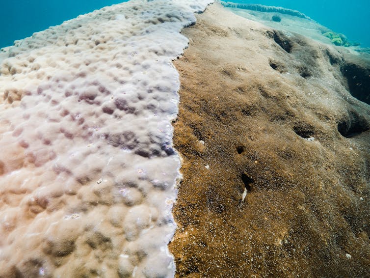
About 70% of Muga dhambi consisted of live coral, but the remaining 30% was dead. This section, at the top of the structure, was covered with green boring sponge, turf algae and green algae.
Coral tissue can die from exposure to sun at low tides or warm water. Dead coral can be quickly colonised by opportunistic, fast growing organisms, as is the case with Muga dhambi.
Green boring sponge invades and excavates corals. The sponge’s advances will likely continue to compromise the structure’s size and health.
We found marine debris at the base of Muga dhambi, comprising rope and three concrete blocks. Such debris is a threat to the marine environment and species such as corals.
We found no evidence of disease or coral bleaching.
‘Old man’ of the sea
A Traditional Owner from outside the region took part in our citizen science training which included surveys of corals, invertebrates and fish. We also consulted the Manbarra Traditional Owners about and an appropriate cultural name for the structure.
Before recommending Muga dhambi, the names the Traditional Owners considered included:
- Muga (big)
- Wanga (home)
- Muugar (coral reef)
- Dhambi (coral)
- Anki/Gurgu (old)
- Gulula (old man)
- Gurgurbu (old person).
Indigenous languages are an integral part of Indigenous culture, spirituality, and connection to country. Traditional Owners suggested calling the structure Muga dhambi would communicate traditional knowledge, language and culture to other Indigenous people, tourists, scientists and students.
A wonder for all generations
No database exists for significant corals in Australia or globally. Cataloguing the location of massive and long-lived corals can be benefits.
For example from a scientific perspective, it can allow analyses which can help understand century-scale changes in ocean events and can be used to verify climate models. Social and economic benefits can include diving tourism and citizen science, as well as engaging with Indigenous culture and stewardship.
However, cataloguing the location of massive corals could lead to them being damaged by anchoring, research and pollution from visiting boats.
Looking to the future, there is real concern for all corals in the Great Barrier Reef due to threats such as climate change, declining water quality, overfishing and coastal development. We recommend monitoring of Muga dhambi in case restoration is needed in future.
We hope our research will mean current and future generations care for this wonder of nature, and respect the connections of Manbarra Traditional Owners to their Sea Country.
Adam Smith, Adjunct Associate Professor, James Cook University; Nathan Cook, Marine Scientist , James Cook University, and Vicki Saylor, Manbarra Traditional Owner, Indigenous Knowledge
August 20 2021
This article is republished from The Conversation under a Creative Commons license.
Juvenile sea turtles ingest hundreds of plastic pieces in Australian waters


“Post-hatchling turtles have adapted to enter the oceanic zone (for green, loggerhead, hawksbill, and olive ridley turtles) or shallow coastal waters (flatback turtles) where they feed opportunistically on a range of organisms. “Normally, these habitats are ideal for their development, but the rapid introduction of plastic debris among their natural food items has made the environments risky.”
Plastic ingestion can cause sea turtles to die from laceration or obstruction of the gastrointestinal tract, as well as malnutrition and chemical contamination.
The study also found plastic in the turtles of Eastern Australia waters was mostly hard fragments likely from a range of consumable products, while Indian Ocean plastics were mostly fibres – possibly from fishing ropes or nets.
Aug 6 2021
Adapted from: https://www.tropicnow.com.au/2021/august/2/jcu-finds-baby-sea-turtles-ingesting-hundreds-of-plastic-pieces-in-australian-waters
Read the original study here: https://www.frontiersin.org/articles/10.3389/fmars.2021.699521/full
Australia’s marine industry value jumps by 28% over two years

Australia’s marine industry contributes more than $80 billion annually to the national economy according to a report released today. The AIMS Index of Marine Industry is a biannual update of the value the marine sector provides to Australia’s wealth by Deloitte Access Economics, commissioned by AIMS. Assistant Minister for Forestry and Fisheries and for Industry Development Senator Jonathon Duniam, who released the report, said Australia’s marine industry was one of the most important, vital and fastest-growing parts of the Australian economy. “The value of Australia’s marine industry increased by more than a quarter between 2015-16 and 2017-18 and has seen a four-fold increase over the past two decades,” he said.
“To put it in perspective, our $81.2 billion blue economy produced more than the agricultural sector ($58.9 billion), coal mining ($69.7 billion) and heavy and civil engineering construction ($68.5 billion) in 2017-18.
“This isn’t surprising if you consider that more than 85% of our population is concentrated near the coast and more than 70% of Australia’s territory lies beneath the ocean.”

Gas, shipbuilding and tourism driving growth
The report found that the total income of the marine industry increased substantially in the two years (by almost 28%), driven by growth in offshore natural gas production (up 79%), shipbuilding and repair (up 57%), and marine tourism (up 11%). Other marine-based activities include, transport, aquaculture and fishing, with the whole marine sector employing nearly 340,000 full time workers.

Chief Executive Officer Dr Paul Hardisty said AIMS’ scientific research contributed to the sustainable productivity of many of marine industries while protecting our oceans. “Marine-based industries build economic value, create employment, and improve people’s livelihoods,” he said. “AIMS is here to help ensure that this occurs in a way that also preserves and protects our unique marine ecosystems now and in the future.” The report, now in its eighth edition, includes breakdowns of key marine industry sub-sectors by state or territory for the first time. The report acknowledges the COVID-19 pandemic brought unprecedented disruption to the Australian economy which will be measured by the next index due to be published in 2022.
The AIMS Index of Marine Industry is a biannual economic update of Australia’s marine sector. The 2020 edition uses the latest data from 2017–18.
From www.aims.gov.au,

July 2 2021
Turning the tables – how table corals are regenerating reefs decades faster than any other coral types

New research out today shows the Great Barrier Reef’s iconic table corals can regenerate coral reef habitats 14 times higher – that’s more than two decades faster – than any other coral type.
Table corals have been dubbed as “extraordinary ecosystem engineers” – with new research showing these unique corals can regenerate coral reef habitats on the Great Barrier Reef faster than any other coral type. The new study highlights the importance of tabular Acropora, and is led by the Australian Institute of Marine Science (AIMS) in collaboration with the Great Barrier Reef Marine Park Authority, the University of Queensland and The Nature Conservancy. AIMS scientist and lead author Dr Juan Carlos Ortiz said the research showed overall reef recovery would slow considerably if table corals declined or disappeared on the Great Barrier Reef. “Table corals are incredibly fast growing. Habitats in exposed reef slopes recover from disturbances at a rate 14 times higher – that’s more than two decades faster – when table corals are abundant,” he said. “Their large, flat plate-like shape provides vital protection for large fish in shallow reef areas and serves as a shelter for small fishes, with some species almost entirely dependent on table corals. “Even after death these corals provide value, as their skeletons are the preferred place for young corals of all types to settle.” Table corals, also known as plate corals, are mostly found in upper reef slopes exposed to wave action, at most mid-shelf and offshore reefs in the Great Barrier Reef. The study found table corals to have unique combination of characteristics: they provided valuable ecological functions, are among the most sensitive coral types and, most importantly, their role was threatened by a low diversity of species which have this growth form. The authors suggest protecting table corals could be an additional management focus. Targeting management to a particular coral type based on its ecosystem function — rather than their risk of extinction alone — would be ground-breaking in terms of ecosystem-based management.

Great Barrier Reef Marine Park Authority’s Assistant Director and study co-author Dr Rachel Pears said table corals were fast growing and sensitive species. “Table corals are still frequently seen on outer reefs, but their presence shouldn’t be taken for granted as they are vulnerable to combined impacts,” she said. “These corals do not handle intensifying thermal stress well, are easily killed by anchor damage, highly susceptible to diseases, and are the preferred meal for crown-of-thorns starfish. “The good news is there are tangible actions we can take to protect these corals such as targeted crown-of-thorns starfish control and anchoring restrictions.” University of Queensland’s scientist and study co-author Professor Peter Mumby said while table corals promoted high rates of recovery, they did not necessarily bring high biodiversity. “We know table corals do a big service for these reefs, but it’s not a silver bullet for recovery,” he said. “Protecting table corals could be part of a suite of actions that look at reef recovery, with other management focused more specifically on protecting biodiversity.”

Professor Mumby said it was also important to remember the biggest threat to the reef was climate change, and effective global action to reduce emissions significantly was paramount to protecting coral reefs. The research drew on decades of data from AIMS long term monitoring program, revealing coral reef habitats took up to 32 years to recover, from 5% coral cover to 30% coral cover, where table corals had not recolonised after disturbances. These low recovery rates were in stark contrast to reefs where table corals returned and recolonised, with these habitats recovering to 30% coral cover in just seven and a half years.
Given their extraordinary ecosystem function, the research indicated table corals should also be considered in restoration initiatives, like coral enhancement or assisted colonisation. “Anyone who has been on the mid-shelf or offshore areas of the Great Barrier Reef would have seen table corals,” Dr Ortiz said. “We can think of table corals as the iconic charismatic ‘mega coral’ of the Great Barrier Reef, just like whales, turtles and dolphins are the Reef’s iconic charismatic megafauna.” The study, titled Important ecosystem function, low redundancy and high vulnerability: the trifecta argument for protecting the Great Barrier Reef’s tabular Acropora, was published in Conservation Letters.
2 June 2021
From www.aims.gov.au,
https://www.aims.gov.au/news-and-media/turning-tables-how-table-corals-are-regenerating-reefs-decades-faster-any-other-coral-type
Can we use bio-fouling organisms to help extract energy from waves?
People living near the coast are familiar with the power of ocean waves. What we see when a typical wave breaks on a beach is the endpoint of a global energy conversion story. It starts with the sun’s heat driving winds whose energy generates ocean waves which grow and often travel thousands of kilometres. In this way, the ocean collects an enormous amount of energy. There’s enough energy in waves coming ashore that every metre of coastline could power around five average homes, and much more during storms. Capturing this energy is not a new idea, but one that faces many challenges. Our research illustrates the potential of enlisting biology in a reversal of the typical marine engineering view that “bio-fouling is bad”. Instead, it looks possible to use the added drag generated by allowing marine organisms to grow on a “naked” wave energy extractor.
Decarbonising energy generation
The continuing interest in innovations in wave power is because most economies now have targets to reduce greenhouse gas emissions over the coming decades. New Zealand has promised to reduce net emissions of all greenhouse gases (except methane from livestock) to zero by 2050. Clearly better energy efficiency is paramount. There is no point investing in clean energy supply and then wasting it, because no form of energy generation is without impact. Solar and wind power are the fastest growing forms of renewable supply globally, but this puts increasing pressure on valuable land. And during times of high demand, the variability of optimal wind and solar conditions is a challenge.
With two thirds of our planet covered in seawater, capturing the energy embodied within ocean waves and tides makes a lot of sense. While some tidal energy technology is now commercially viable, wave energy is following a more convoluted trajectory, with many options for how the conversion actually happens.
New Zealand excels in marine innovation in extreme yachting and aquaculture, but there is almost no maritime engineering focused on marine energy generation, despite having an exclusive economic zone 15 times larger in area than the country’s landmass.
Untapped wave energy
Regardless of the design, wave energy converters are vulnerable to damage in inevitable storms. Despite this challenge, current technologies like the Wello Penguin are getting close to being able to produce energy at a cost comparable with other renewable energy generation methods. What has really pushed the marine renewable energy field forward in the last decade has been the growth of offshore fixed-foundation wind farms. This has been a game changer as it socialised the marine setting and, through scale, increased the economic viability of the supply chain. It is common to look to nature to help in environmental design. Energy converter designs are often inspired by nature, with ideas ranging from nodding ducks to sea snakes. Some designs get more serious in how they use biomimicry. Our research explores a hybrid solution, combining physics and biology, as a pathway for future marine energy. The Bio-Oscillator looks at how species like large macroalgae and mussels could be integrated into the submerged structure of a wave-power generator. This is possible because parts of the structure are required only to add drag and inertia and experience only relatively little motion during operation.
Using local species of algae or mussels has several benefits. They grow and regenerate naturally and, importantly, will have only limited impact if they are damaged during storms. It is also common to look at ways to connect renewable energy sources to existing ocean infrastructure such as navigation buoys or aquaculture farms. Approaches like the Bio-Oscillator could generate both a harvestable crop of shellfish or macroalgae – as well as producing renewable energy. The United Nations decade of ocean science for sustainable development is a perfect setting for exploring the many opportunities that now exist to reduce energy emissions and, in doing so, head off the forecast threats caused by our present way of living.
June 7 2021
First published https://www.miragenews.com/can-we-use-bio-fouling-organisms-to-help-572463/
Southern reefs survive the hot summer of 2020

Under the right conditions, corals can recover from bleaching events. This is the case for multiple reefs in the southern Great Barrier Reef, which avoided wide-spread mortality from the 2020 mass coral bleaching event. These reefs escaped prolonged heat stress and did not have ongoing impacts from crown-of-thorns starfish – giving the corals a chance to bounce back from bleaching. Australian Institute of Marine Science’s (AIMS) monitoring program team leader Dr Mike Emslie said the six reefs, spanning offshore between Shoalwater Bay and Agnes Waters, were observed closely by scientists because of their specific disturbance history. “These reefs were the perfect candidates for our team to observe their recovery, the corals were not severely bleached and did not have extra stress from the coral eating starfish,” he said. “What is often misunderstood is corals do not immediately die from bleaching – bleaching is a stress response, and they can recover if given the opportunity.

“Our preliminary results show these reefs appear to have had little impact from the 2020 mass coral bleaching, with an increase of hard coral cover at most reefs. “This increase is what we predict in the absence of disturbance. The reefs were given the opportunity to recover because 75% of southern reefs were not exposed to sustained temperatures expected to cause mortality and were also free the from the additional stressors of crown-of-thorns starfish.” Research Program Director Dr Britta Schaffelke said disturbances, such as crown-of-thorns starfish, can be significant in hindering the recovery process of reefs following bleaching events. “AIMS scientists lead world-class research in this effort to understand cumulative impacts on coral reefs,” she said. While the 2019-2020 mass coral bleaching event was the third event in five years, it was the first time such widespread bleaching has occurred in the southern region. “These results are encouraging for the southern region – but we are still in the water conducting surveys all along the Great Barrier Reef to understand the full impact of the 2020 mass bleaching event, and indeed other disturbances, for both coral mortality and recovery,” said Dr Emslie.
AIMS’ Long-Term Monitoring Program has measured the condition of reefs more than 30 years, spreading over 490 reefs within the Great Barrier Reef Marine Park. AIMS’ Annual Summary Report on coral reef condition for 2019/20 is drawn from surveys undertaken between September 2019 and June 2020.
From www.aims.gov.au,
2 March 2021
AI to ‘go fish’

Artificial intelligence may soon be counting and classifying Australia’s tropical fish populations if at least one of the four Australian technology businesses to receive Australian Government seed funding is successful. The four small to medium-sized businesses are sharing funding of almost $400,000 from the latest round of the Department of Industry, Science, Energy and Resources’ Business Research and Innovation Initiative. The businesses will use the funding to address a challenge set by the Australian Institute of Marine Science (AIMS).
They will each run a project to scope the feasibility of creating an innovative solution to analyse fish video survey data, harnessing advanced technologies such as machine learning and artificial intelligence.
Currently, AIMS uses Baited Remote Underwater Video Stations (BRUVS) to capture footage of fish populations to better understand reef health. The method can give estimates of the fish species present, their numbers, sizes and biomass which provide critical indicators of the health of the fish community, but it has a drawback. This BRUVS footage, which can capture up to 70 different species per video, is manually analysed by an experienced researcher – a labour-intensive and time-consuming task which limits the ability to scale-up data collection.
The challenge is to develop technology that can learn to identify different species, count them, and measure fish length, quickly and efficiently delivering critical information about fish communities, removing the potential for observer bias. The solution needs to be easy enough for a non-technical user to operate – such as citizen scientists and Indigenous and local communities – which would lead to a significant scaling up of the data collected in Australia and beyond. It could also provide opportunities to expand the monitoring other marine life including sharks, rays and sea snakes. AIMS Technology Development Engineering Team Leader Melanie Olsen said it was AIMS’ first BRII Challenge and they were delighted with the strong interest it attracted and the large number of high-quality applications. The four companies (Tekno (GAIA Resources), Mapizy, Silverpond and Harrier Project Management) will be competing to produce the most compelling feasibility study. The top two solutions will then each be eligible for a grant of up to $1 million to work with AIMS to develop a prototype.
“We look forward to working closely with these technology innovators to develop a solution that could potentially revolutionise the way diverse fish populations are monitored, not only in Australia, but across the world,” Ms Olsen said. “This is another example of the way we work with industry to apply new technologies, such as AI, to the problems our ecologists are facing and to expand our capabilities and the services we can deliver to the Australian public.”
From AIMS first published: https://www.aims.gov.au/news-and-media/ai-go-fish,
8 February 2021
West coast reefs warming up

Scientists are keeping a close eye on reefs along the west coast of Australia, with sea surface temperatures reaching levels where some coral bleaching is occurring. The thermal stress has been accumulating over the high-risk summer period and is expected to continue until April, according to forecasts from the Bureau of Meteorology (BoM).
Australian Institute of Marine Science’s (AIMS) coral ecologist Dr James Gilmour said the areas of concern include reefs in the Pilbara, Ningaloo, Shark Bay and the Abrolhos. “Low level bleaching has already been observed in parts of Exmouth Gulf and in the Dampier Archipelago, which were reported by officers from the Department of Biodiversity Conservation and Attractions (DBCA),” he said.
“While cloud cover and rainfall from a recent tropical low has reduced some heat stress, the risk of bleaching will continue in the coming weeks in central to southern Western Australian reefs.” The recurring threat of bleaching to WA coral reefs has galvanised collaborative efforts across government and research institutions, drawing on the most current observations and forecasts based on data provided by BoM, National Oceanic and Atmospheric Administration (NOAA), CSIRO, the Integrated Marine Observing System (IMOS) and the University of Western Australia (UWA).
“In the coming weeks, we’ll have many eyes on the reef to report coral bleaching and in-water surveys will be conducted by several research agencies, including AIMS, DBCA and CSIRO,” Dr Gilmour said. “This week we are conducting in-water surveys around Ningaloo – this monitoring will extend to other reefs at risk in the coming weeks.
“We are encouraging people who are visiting these reefs to download our app ArcGIS Collector and report any sightings of coral bleaching.” Currently, on the other side of Australia, temperatures are below bleaching thresholds for the most part of the Great Barrier Reef. The 2020-2021 summer has been characterised by a La Niña event, which is forecasted by BoM to last until Autumn. This climate driver has meant above average rainfall has been likely for eastern and some northern parts of Australia, meaning a lower risk of bleaching in the Kimberley and the Great Barrier Reef.
From www.aims.gov.au
First published: https://www.aims.gov.au/news-and-media/west-coast-reefs-warming,
16 February 2021
Octogenarian snapper found in WA becomes oldest tropical reef fish by two decades

An 81-year-old midnight snapper caught off the coast of Western Australia has taken the title of the oldest tropical reef fish recorded anywhere in the world. The octogenarian fish was found at the Rowley Shoals—about 300km west of Broome—and was part of a study that has revised what we know about the longevity of tropical fish.
The research identified 11 individual fish that were more than 60 years old, including a 79-year-old red bass also caught at the Rowley Shoals. Australian Institute of Marine Science (AIMS) Fish Biologist Dr Brett Taylor, who led the study, said the midnight snapper beat the previous record holder by two decades. “Until now, the oldest fish that we’ve found in shallow, tropical waters have been around 60 years old,” he said. “We've identified two different species here that are becoming octogenarians, and probably older.”
Dr Taylor said the research will help us understand how fish length and age will be affected by climate change.
“We’re observing fish at different latitudes—with varying water temperatures—to better understand how they might react when temperatures warm everywhere,” he said. The study involved four locations along the WA coast, as well as the protected Chagos Archipelago in the central Indian Ocean. It looked at three species that are not targeted by fishing in WA; the red bass (Lutjanus bohar), midnight snapper (Macolor macularis), and black and white snapper (Macolor niger). Co-author Dr Stephen Newman, from the WA Department of Primary Industries and Regional Development, said long-lived fish were generally considered more vulnerable to fishing pressure.
“Snappers make up a large component of commercial fisheries in tropical Australia and they’re also a key target for recreational fishers,” he said. “So, it’s important that we manage them well, and WA’s fisheries are among the best managed fisheries in the world.” Marine scientists are able to accurately determine the age of a fish by studying their ear bones, or ‘otoliths’. Fish otoliths contain annual growth bands that can be counted in much the same way as tree rings. Dr Taylor said the oldest red bass was born during World War I.
“It survived the Great Depression and World War II,” he said. “It saw the Beatles take over the world, and it was collected in a fisheries survey after Nirvana came and went.” “It’s just incredible for a fish to live on a coral reef for 80 years.”
The research is published in the journal Coral Reefs.
Funding was provided by the Bertarelli Foundation and contributed to the Bertarelli Programme in Marine Science.
1 December 2020
Squid-inspired robot swims with nature’s most efficient marine animals

Scientists at the University of Southampton and University of Edinburgh have developed a flexible underwater robot that can propel itself through water in the same style as nature’s most efficient swimmer – the Aurelia aurita jellyfish.
The findings, published in Science Robotics, demonstrate that the new underwater robot can swim as quickly and efficiently as the squid and jellyfish which inspired its design, potentially unlocking new possibilities for underwater exploration with its lightweight design and soft exterior.
Co-author Dr Francesco Giorgio-Serchi, Lecturer and Chancellor’s Fellow, at the School of Engineering, University of Edinburgh, said: “The fascination for organisms such as squid, jellyfish and octopuses has been growing enormously because they are quite unique in that their lack of supportive skeletal structure does not prevent them from outstanding feats of swimming.” The “cost of transport” (the ration of power to speed and weight) is used to compare efficiencies of species across biology, and by this measure the jellyfish is the most efficient animal in nature, easily beating running and flying animals and bony fish. The new robot was developed at the University of Southampton and is the first submersible to demonstrate the benefits of using resonance for underwater propulsion. Resonance refers to large vibrations that occur when applying a force at the ideal frequency, like pushing a child on a swing. This allows the robot to use very little power but generate large water jets to push itself forward. The simple but effective mechanism used consists of a rubber membrane enclosing eight 3D-printed flexible ribs, which together form a ‘propulsive bell’. A small piston in the top half of the robot taps this bell repeatedly so that it expands and then springs back. This mimics a jellyfish’s swimming technique and produced the jets of fluid to propel the robot through the water. When the piston operates at with the correct frequency – the natural resonance for the components – the robot can move at one body length per second and match the efficiency of the Aurella aurita jellyfish.
The latest tests show the new robot is ten to fifty times more efficient than typical small underwater vehicles powered by propellers. This increased efficiency, combined with the additional benefits of the robot’s soft, flexible exterior would make it ideal for operating near sensitive environments such as a coral reef, archaeological sites, or even in waters crowded with swimmers. Co-author Thierry Bujard, a Masters student in Naval Architecture at the University of Southampton, designed and built the robot in a matter of months. Thierry said, “Previous attempts to propel underwater robots with jetting systems have involved pushing water through a rigid tube but we wanted to take it further so we brought in elasticity and resonance to mimic biology. I was really surprised by the results, I was confident that the design would work but the efficiency of the robot was much greater than I expected.” Dr Gabriel Weymouth, Associate Professor in the University’s School of Engineering, who supervised the project added, “The great thing about using resonance is that we can achieve large vibrations of the propulsive bell with a very small amount of power; we just need to poke it out of shape and let the elasticity and inertia do the rest. This has allowed us to unlock the efficiency of propulsion used by sea creatures that use jets to swim.
“The last decade has seen a surge in research into flexible and biologically-inspired robots, such as Boston Dynamic’s “Big Dog”, because they can be much more versatile than standard industry robots. This research demonstrates that these concepts can also be applied to underwater robotics.
“There are still many challenges and exciting possibilities to explore with soft underwater robotic technologies. We are now looking to extend the concept behind this robot to a fully manoeuvrable and autonomous underwater vehicle capable of sensing and navigating its environment.”
January 21 2021
Original article: https://www.miragenews.com/squid-inspired-robot-swims-with-nature-s-most-efficient-marine-animals/
Marine Science News
When a beach walk feels like grief: disasters like SA’s algal bloom cut us off from nature when we need it most
As oceans warm, tropical fish are moving south. New friendships may be helping them survive
Jaws at 50: how a single movie changed our perception of white sharks forever
The ocean can look deceptively calm – until it isn’t. Here’s what ‘hazardous surf’ really means
Marine Science facts
The vampire squid gets its name not because it has a taste for blood but from the dark skin on its arms that makes it look like it’s wearing a Dracula-esque cape?
The oceans provide 99% of the living space on the planet containing 50-80% of all life.
The Oceans cover 70% of the earths suface
The deepest part of the ocean is called the Mariana Trench, which is around 7 miles deep and is located in the South Pacific Ocean.
The water pressure at the bottom of the Mariana Trench is eight tons per square inch. This means the pressure there is enough to crush you.
The largest mountain range is found underwater and is called the Mid-Oceanic Ridge that is around 65,000 kilometres long.
Sponges are older than dinosaurs.
Half the Oxygen we breath is produced in the Ocean.
Irukandji jelly fish, with just a brush of venom leaves almost no mark. But after about a half hour you develop Irukandji syndrome, a debilitating mix of nausea, vomiting, severe pain, difficulty breathing, drenching sweating and sense of impending doom. You get so sick that your biggest worry is that you’re not going to die.
The most remote point in the oceans is called Point Nemo.
The Pacific, Atlantic, and Indian oceans are known as the three major oceans.