
Marine Science News 2015
Shark safety tips: sorting out fact from fiction
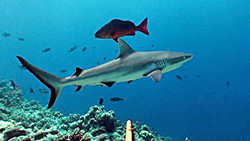
Alison Kock, South African Institute for Aquatic BiodiversityThere are more than 500 species of shark and only three of them pose a significant threat to humans. These are the great white, bull or Zambezi and tiger shark.
The probability of being bitten by a shark is statistically extremely low. There were 72 shark bites, three of them fatal, reported worldwide in 2014. Considering that hundreds of thousands of people use the ocean daily for recreation, this is a staggeringly low number.
There is a list of shark safety tips to follow that will reduce your individual risk even further. But have you ever wondered where the advice comes from and how to use it?

Shark safety advice is geared towards reducing the probability of an encounter between people and large, predatory sharks. There is always a chance of encountering a shark in areas where they occur, but some locations, times and situations are more risky than others.
Sharks do not randomly swim around the ocean. They frequently follow specific migration routes, predictable feeding opportunities and are temporarily resident in some areas, either to feed, reproduce or rest.
By avoiding times of higher risk one can significantly reduce the likelihood of encountering a shark.
Hot spots off South Africa’s coast
The predator-prey relationship between great white sharks and Cape fur seals provides a good case of how effective this can be. At Seal Island, False Bay off the Western Cape coast, over 80% of seals attacked are inexperienced seal pups because they swim in areas and at times of high shark risk. More experienced adult seals avoid these high risk conditions and are rarely attacked.
In general, seal colonies and adjacent beaches in South Africa, from Cape Point in the Western Cape to another coastal city Port Elizabeth, are great white shark hotspots. Encountering a shark in these areas is relatively high. River mouths and adjacent beaches in sub-tropical and tropical areas of southern Africa are frequented by bull sharks for feeding and reproduction.
In some cases the higher risk may be seasonal, such as in False Bay, where great whites are seasonally more abundant near beaches over summer time. Sometimes higher risk is associated with major events, such as the annual sardine run along the east and KwaZulu Natal coasts when various shark species follow an abundance of fish along the coast. Bull sharks are known to be more active following floods and heavy rains.
At a smaller scale, shallower is better. Even though sharks are capable of swimming in very shallow water, most shark activity is in deeper water. Shark Spotters in False Bay record over 70% of great white shark sightings behind the surf zone, in deeper water.
Sometimes predicting or identifying risky situations is not possible and on average South Africa experiences four shark bites, two of them fatal, in a year. In some years there are no incidents at all; in others there have been up to eight.
Sharks like to surprise their prey
Terrestrial predators like lions and leopards use vegetation and topography to ambush their prey. Similarly, large sharks like to hunt near drop-offs, in-between sand banks and on the edge of kelp forests, where they wait to surprise seals, fish or turtles swimming through. Sharks also use low light like dawn and dusk and murky water to hide in, and sneak up on their prey. Sharks have a sensory advantage in these conditions.
Sharks, especially bull sharks, are attracted to areas with high sewerage outfalls or other effluents, such as near abattoirs. Fishing harbours, and areas used regularly by fishermen should be avoided, especially when fish catches are high.
There are a number of visual cues one can use to identify such high risk times. Diving seabirds and dolphin sightings indicate the presence of bait fish like sardine, anchovy, and herring. Lots of fishermen are a good cue that the fish are biting. The baitfish attracts larger predatory fish and other smaller sharks, which are prey for large sharks. Contrary to popular belief large sharks are not deterred by dolphins. In fact dolphins and large sharks will often feed on the same fish and in some cases dolphins are potential food for large sharks.

Stay in a group, and research your area
One of the best pieces of advice is to stay in a group. Sharks are more likely to attack a solitary individual, a group offers extra vigilance to spot an approaching shark and there is someone close by to help in an emergency.
Do not enter the water if you are bleeding from an open wound, and enter with caution if you are menstruating. It is unlikely that this will attract sharks from far, but sharks have an acute sense of smell and it may mean you are singled out if a shark is close by.
Avoid wearing contrasting colours and shiny jewellery because sharks see contrasting colours very well and the shimmer given off by jewellery resembles the shine of fish scales. This is particularly true for bull sharks in murky water.
There are a number of shark deterrents on the market, from magnetic bracelets to wetsuits which mimic sea snakes. Consider using a personal Shark Shield which is an electronic device used to repel sharks. To date this electric shark repellent is the only deterrent on the market which is backed up by independent research. However, its effect is species and behaviour dependent and does not provide a 100% guarantee.
Where available choose to use beaches with shark safety strategies, like shark spotters, life guards or exclusion nets in place. If visiting a remote beach, make sure that you have a basic medical first aid kit as well as emergency numbers easily accessible.
Bear in mind that each location will be affected differently according to the species present, and its reason for being there, as well as your activity like swimming or surfing. Research your area or contact a local shark scientist for more information. Importantly before heading out into the water again, take a few minutes to ask locals about recent shark sightings and assess the prevailing conditions for any unusual marine activity.
Alison Kock, Research Manager, Shark Spotters and Honorary Research Associate, South African Institute for Aquatic Biodiversity
This article was originally published on The Conversation. Read the original article.
Aug 4 2015
Early warning signs of widespread coral bleaching in 2016

Widespread coral bleaching in the Northern Hemisphere coral reef regions provides an early warning that Australian reefs are likely at risk in the summer of 2016. AIMS researchers are gearing up a research program responsive to this risk.
Record breaking summer ocean temperatures have led to widespread coral bleaching in the northern hemisphere. These hot conditions are predicted to extend into the Southern Hemisphere in the upcoming southern summer. The National Oceanic & Atmospheric Administration (NOAA) has now declared the ‘third global coral bleaching event ’, following the two previous mass bleaching events in 1998 and 2002 that have devastated many coral reefs around the world.
Satellite data delivered through NOAA’s Coral Reef Watch program identify bleaching conditions and areas of risk, triggering the need for a response.
Currently, the most severely affected locations are the Hawaiian Islands and the Caribbean. Closer to home, modelling predicts that a strong El Niño will continue to develop in the Pacific Ocean, which could cause bleaching in the Indian and south eastern Pacific Oceans in early 2016. This could put the Great Barrier Reef, Ningaloo Reef and some of the other smaller Australian coral reef systems at risk of similar widespread bleaching if warmer than normal ocean temperatures develop this summer.
The Australian Institute of Marine Science has a long history in researching the impacts of climate change on corals and other reef organisms, including the causes and effects of coral bleaching. AIMS researchers have reconstructed past climate conditions, frequency historic bleaching events, monitored and modelled climate trends and future climate scenarios to predict how the reef is likely to respond to such changes. AIMS’ current work on adaptation mechanisms of coral reef animals is aimed at finding out whether some coral species and some locations might be able to cope with the effects of climate change, and determine the characteristics and locations that may provide refuge.
To be prepared for a possible mass bleaching event in the coming summer, AIMS is ramping up its targeted research to better understand coral responses to the predicted high sea temperatures, reef responses to cumulative pressures from climate change and poor water quality, and coral reef adaptation in a warming ocean. Building on baseline information, AIMS’ goal is to collect new data that can be directly compared to previous mass bleaching observations. The aim is to identify environmental conditions and management solutions that identify locations with the greatest tolerance and resilience to survive thermal stress events. The results of this work will assist the development of future management strategies for reef environments, particularly the Great Barrier Reef.
Oct 14 2015

Source: Australian Institute of Marine Science
The secret to becoming an ocean giant
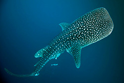
How do the world’s largest fish – whale sharks – reach such immense sizes when they feed on some of the smallest prey in the ocean?
The answer, according to a new study, is that whale sharks are very efficient foragers, using a combination of "yo-yo" like swimming to save energy and specially-adapted bodies to maximise heat conservation as they search for "krill" (tiny, shrimp-like animals) that they feed on in cold ocean depths.
Dr Mark Meekan, Principal Research Scientist at the Australian Institute of Marine Science (AIMS), is lead author of the study and explains their findings, “Whale sharks are negatively buoyant meaning they naturally sink. When feeding, they allow themselves to glide gently down to the krill in deep water, which means they don’t expend much energy in swimming". “We estimate that this behaviour, followed by a steep return to the warmer surface waters, allows them to conserve up to 30% of the energy they would use if just swimming horizontally".
“These ocean giants have another trick up their sleeve”, says Dr Meekan. “Their critical organs are surrounded by huge blocks of white muscle that appear to insulate the whale shark, so that it stays warmer for longer, even during these long descents to much cooler depths”. “For whale sharks, the larger they get, the more heat they can store and the longer they can forage in deep water”, notes Dr Meekan. “Because of this, we think they have evolved to become bigger and bigger, so that today they grow up to 18 metres long and can reach 34 tonnes in weight – larger even than many whales”.
The scientists were able to record the swimming behaviour and location of whale sharks near Ningaloo Reef in Western Australia using sophisticated data and video recorders and satellite tags. They found that whale sharks spent almost 60% of their time at the surface, where they bask in warm waters. “Whale sharks will dive down as deep as 500 metres and the water temperature can drop up to 20 degrees”, explains Dr Meekan, “they therefore need to spend a lot of their time at the surface to heat up again before pursuing their tiny prey in the cold ocean depths". “Unfortunately for these magnificent creatures being at the surface for such long periods can leave them vulnerable to encounters with large container vessels, tankers or even hunters".
“Up to 25% of the whale sharks in the Indian Ocean bear scars from boat-strikes, and our research helps us understand why this is happening. We now need to educate others to this danger and try to manage our behaviour to better protect these giants of the ocean”. The paper “Swimming strategy and body plan of the world’s largest fish: implications for foraging efficiency and thermoregulation” by Mark Meekan, Lee Fuiman, Randall Davis, Yuval Berger and Michele Thums appears in the journal Frontiers in Marine Science
http://journal.frontiersin.org/article/10.3389/fmars.2015.00064/abstract
© 1996-2014 Australian Institute of Marine Science
Sept 15 2015
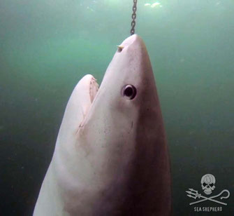
Documents reveal mass capture of over 84,800 marine animals in Queensland
A Freedom of Information request initially started by Sea Shepherd Australia and then followed up by Shark Files Queensland, has revealed the staggering impact that the Queensland Shark Control Program has had on a large variety of marine life, including over 9,000 unborn pups.
Catch-data dating back to November 1962, reveals that over 84,800 marine animals have been ensnared in the program, including many, vulnerable, endangered and critically endangered species.
While the majority of marine species caught were sharks, more than 50% caught were whaler sharks, with blacktip reef sharks toping the ranks in this category, which also includes 310 dusky sharks and 265 sandbar sharks, both rated as vulnerable by the International Union for the Conservation of Nature (IUCN).
This was followed by over 15,000 tiger sharks and then by over 14,000 hammerhead sharks, including 850 scalloped and 280 great hammerheads which are both rated as endangered by the IUCN.
As a result of this data, National Shark Campaign Coordinator for Sea Shepherd Australia, Natalie Banks is calling on the Queensland Fisheries Minister, Bill Byrne to review the species of sharks targeted by the program.
“It is honestly a stomach-turning exercise to read through the list of marine animals captured by this program and in terms of protected sharks, to see 265 critically endangered grey nurse sharks, 121 Makos and 13 whale sharks caught up in the list of targeted species by the Queensland Shark Control Program,” Natalie said.
“There has been 54 species of sharks that have been caught on the drum lines and in shark nets in Queensland, most of which are not a threat at all to ocean users.”
QLD Shark Control Program 1962-2014 click to view
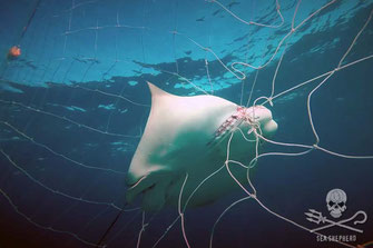
But even without these sharks being considered as by-catch, over 26,700 marine animals, including rays, turtles, fish, dugongs, dolphins and whales, some of which have Federal protections, have been caught by the program.
The species involved in the by-catch include over 5,000 turtles, 1,014 dolphins, nearly 700 dugongs and 120 whales – all of which are federally protected marine species.
In total, over 8,200 marine species that have Australian Government protections, have been caught by the Queensland Shark Control Program, which includes 719 loggerhead turtles, 442 manta rays and 33 critically endangered hawksbill turtles.
“With scientists questioning the effectiveness of drum lines and shark nets, it is extremely heartbreaking to see the impact that the Queensland Shark Control Program has on our precious marine life,” Natalie said.
“This is why Sea Shepherd is calling on the Queensland Government to consider non-lethal options which have proven to work, such as the eco-friendly shark barrier in place at a local beach in Western Australia and Shark Spotters, which has been in place in Cape Town, South Africa, keeping ocean users safe without the horrendous by-catch.”
“It is time for Australia to move on from the 1930’s when shark nets were first installed in the country, and to embrace new technology which protects both ocean users and our precious marine life,” Natalie said.
Original article: http://www.seashepherd.org.au/news-and-commentary/news/documents-reveal-mass-capture-of-over-84-800-marine-animals-in-queensland.html
01 September 2015
Sharks on film! Global shark and ray survey begins at 400 reefs
The Australian Institute of Marine Science (AIMS) and James Cook University (JCU) are working with a team of US and other international researchers, to capture underwater videos of sharks and rays at 400 locations from little-surveyed coral reefs around the world. The survey, called the "Global FinPrint" is sponsored by Vulcan Inc., a Paul G. Allen company in the US.
“This three year study is important to conservation and science as pressures on shark and ray populations increase. One quarter of the sharks, rays, and skates in the world are now threatened with extinction. These underwater surveys will assess and gather underwater video data that is needed to understand how best to protect reef species,” said AIMS scientist, Dr Michelle Heupel.
“Globally a quarter of shark and ray species are facing an elevated threat of extinction. This research will help better to understand the status of sharks and guide decisions about how to protect them better,” said JCU Professor, Colin Simpfendorfer.
The scientists will be surveying the reefs of the Indo-Pacific, the tropical western Atlantic, and southern and eastern Africa and Indian Ocean islands. The new data will be consolidated with thousands of hours of existing Baited Remote Underwater Video (BRUV) data to form a single dataset for analysis.
The research is led by Dr Demian Chapman of Stony Brook University in the US. The team includes Drs Michelle Heupel, Aaron MacNeil and Mark Meekan from AIMS, Dr Colin Simpfendorfer (JCU and IUCN Shark Specialist Group Co-Chair) and Dr Mike Heithaus (Florida International University).
The survey will also assist in understanding how marine ecosystems are affected in the absence of sharks.
"Although sharks are among the most widespread predators in the ocean, we understand remarkably little about their overall role in ocean ecosystems. By surveying a wide diversity of reef conditions, we hope to understand just how important they are to the health of coral reefs and, ultimately, to marine environments as a whole,” added AIMS scientist, Dr Aaron MacNeil.
As sharks are declining in numbers, this is important as many countries rely on healthy coral reefs for food security, tourism and coastal protection.
“A key element of the project is that we will fund and enable networks of collaborators across the globe to participate in the work. Ultimately, this will be a project that involves a very wide cross-section of the community of researchers and stakeholders, including citizen scientists. Our project doesn’t just seek to document, we also seek to enable local researchers and to build capacity for better management outcomes” explained AIMS scientist, Dr Mark Meekan.
Researchers, policy makers, international governments and others will be able use this database to help inform conservation priorities, such as identifying and protecting areas with large or important shark populations, and to better understand the ecological importance of sharks as apex predators.
07 July 2015
Source: Australian Institute of Marine Science
We already cull thousands of predatory sharks a year, but shark attacks are rising
The Lennox-Ballina board riders club should be congratulated on attempting to bring the community together to find a common voice to the increasing shark encounters in the region. Community voices need to be heard on this topic. It is no surprise to me however, that without being given the opportunity to learn about the whole range of options available to them, and to then be surveyed on each option, the majority supported a cull of sharks. Without understanding the pros and cons of each option available, they have made an uninformed guess at what might work.
The media frenzy that followed is also to be expected. Across the globe, people are being told "Australians want to cull sharks." When in reality, the situation is much, much the opposite. A small minority of people support a shark cull. And when given factual information on the options available, those figures reduce even further.
The NSW authorities do not support a shark cull. The WA community overwhelmingly did not support a shark cull. And generally, the Ballina-Lennox Head community are not supportive of a shark cull.
But let's look as this further. New South Wales are already culling sharks... Thousands of predatory sharks are killed annually, mainly through commercial fishing and in shark nets. Yet shark bites and attacks continue to happen. Hawaii killed over 4,500 tiger sharks over 18 years and found that the level of shark attacks remained the same prior to, and after, culling sharks.
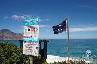
It is my belief that people want something to be done and immediately. And this is understandable. People are scared. But decisions on how to protect the community should not be based on fear. Two immediate solutions which have been proven to work and available right now for the Ballina and Lennox Head community are a shark spotting programme and electronic deterrents. As a scuba diving instructor, I use a Shark Shield for peace of mind. This device was recently proven to work 90% of the time by the University of Western Australia. Given that we can not ever protect ourselves 100% when entering the habitat of wildlife, and that shark encounters are rare, I like those odds.
Shark Spotters is an initiative that started over a decade ago by volunteers specifically for the surfing community in Cape Town, South Africa. They use a system of flags and alarms to alert ocean users of shark activity at eight beaches from 8am to 6pm. In close to 11 years they have spotted over 1,700 sharks and during this time there has been one fatality (low visibility spotting day and black flag up to indicate this) as well as a serious shark attack where the man chose to ignore all the warnings provided.
Again.... Given there is no 100% solution, this initiative offers a great deal more peace of mind than a 150m shark net which is not enclosure that is in 17 days of the month, and in just the last 10 years alone, has not prevented these unwanted shark encounters at some of New South Wales most popular and netted beaches:
16 April 2005 – Bronte – Simon Letch (40) had surfboard bitten by bronze whaler
15 March 2006 – Bondi – Blake Mohair (15) had his surfboard nudged by a 2m bronze whaler
11 April 2006 – Newcastle – Luke Cook (15) received minor lacerations on his foot from a juvenile bronze whaler while surfing
12 February 2009 – Bondi – Glen Orgias (33) loses left hand after being bitten by 2.5m white shark while surfing
1 March 2009 – Avalon – Andrew Lindop (15) bitten on leg by suspected 2.6m white shark while surfing
26 December 2009 – Avoca - John Sojoski (55) received lacerations to lower leg after accidently stepping on shark
11 Feb 2010 – Mona Vale – Surfer Paul Welsh (46) bitten on left lower leg by a wobbegong shark while teaching son (10) to surf
7 December 2011 – Maroubra – Ronald Mason (14) bitten on leg by a wobbegong while surfing
3 Jan 2012 – North Avoca – Surfer Mike Wells (28) receives about 50 puncture wounds to right arm by a suspected bronze whaler
18 Jan 2012 – Redhead Beach – Glen Fokard (44) bitten by white shark on thigh while surfing
17 Oct 2014 – Avoca – Surfer Kirra-Belle Olsson (13) was bitten on left calf and ankle, and received puncture wounds to left foot while surfing
5 Feb 2015 – Merewether – Bodyboarder Ben McPhee bitten on ankle by 1.8m shark (believed to be a bull shark)
It's time to get real about solutions on how to protect loved ones.
by Natalie Banks - Australian Operation Apex Harmony Coordinator
Is the Queensland Government killing sharks and marine life without a permit to do so?
Discrepancies in the actual number of drum lines verses permitted
Sea Shepherd Australia is demanding answers regarding the use of up to nine drum lines being used within the World Heritage Great Barrier Reef Marine Park without a required permit.
After extensive conversations with both the Great Barrier Reef Marine Park Authority and the Department of Fisheries Queensland, Sea Shepherd has uncovered a range of discrepancies, the most damning being the use of up to nine drum lines by the Queensland Government, without permission from the federally governed Great Barrier Reef Marine Park Authority.
Managing Director for Sea Shepherd Australia, Jeff Hansen is shocked that the Queensland Government could get this process so wrong, by not only using more drum lines than permitted, but also having discrepancies within the Department of Fisheries own public records.
“It is beyond belief that the Department of Fisheries Queensland can show such disdain for marine creatures by having these death traps in the World Heritage Great Barrier Reef Marine Park to begin with, let alone having more drum lines than permitted, causing more damage to our precious marine ecosystems.”
“Questions must be asked how this could occur, and we are now requesting the Federal Government to thoroughly investigate the way the Queensland Government deploys its drum lines.”
This request comes after Sea Shepherd uncovered an application by the Queensland Government to continue using drum lines in the Great Barrier Reef, lodged six years ago in April 2009, which to date has gone unanswered by the Great Barrier Reef Marine Park Authority. This was part of an investigation which led to a petition run by Sea Shepherd Australia requesting the removal of drum lines and shark nets within the UNESCO Great Barrier Reef Marine Park, attracting over 34,500 signatures.
The petition was forwarded to the Great Barrier Reef Marine Park Authority in April this year, and Sea Shepherd is still awaiting a response.
“These Government agencies are blatantly treating endangered and protected marine life with utter disdain, and should be completely embarrassed of the lack of importance they have placed on these issues. It shows a complete disconnection from nature and a lack of respect for our precious marine life and future generations” Mr Hansen said.
“Last year in Western Australia, we saw the state’s Environmental Protection Authority raise concern over the impacts of 76 drum lines which ultimately stopped the program, yet just in the Great Barrier Reef Marine Park alone, there is more than 190 drum lines being used; with non-lethal shark mitigation strategies available today, we don’t need to choose between protecting people or marine life, we can do both.”
Discrepancies between the numbers of drum lines and nets used in Queensland depicted on PDF maps and within Excel spreadsheets can be found on the Department of Fisheries website page:https://www.daf.qld.gov.au/fisheries/services/shark-control-program/shark-control-equipment-and-locations - specifically Emu Park, Fishermans, Trinity, Yorkey’s Knob and Halloways beaches.
While the discrepancies between the number of drum lines permitted and used can be seen when comparing the PDF maps and spread sheets to the Great Barrier Reef Marine Park Authorities permit (attached) – specifically Cooee Bay, Elmeo Beach, Florence Bay and Radical Bay.
03 July 2015
From: http://www.seashepherd.org.au/news-and-media/2015/07/03/is-the-queensland-government-killing-sharks-and-marine-life-without-a-permit-to-do-so-1706
Roadmap to recovery for the world's reef fishes…where the magic number for fish is: one tonne
Researchers studying fish populations have uncovered the impact fishing has had on the world's coral reefs and charted a roadmap for the recovery of reef ecosystems currently under threat from overfishing.
Coral reefs are home to thousands of species of fish and provide millions of people with food and income, yet reef ecosystems have been severely depleted by fishing.
"By studying remote and marine protected areas, we were able to estimate how much fish there would be on coral reefs without fishing, and how long it should take newly protected areas to recover,” says study lead author, Dr Aaron MacNeil from the Australian Institute of Marine Science.
“This allows us to gauge the impact of reef fisheries, and make informed management decisions that include timeframes for recovery," Dr MacNeil says.
As part of a global study into the recovery potential of coral reefs published in the journal Nature, the researchers examined more than 800 reefs around the world.
They found that the vast majority of fished reefs are missing more than half of their expected fish populations.
"Although fishing has more than halved fish numbers on many reefs, we were encouraged to find that substantial biomass remained where some form of management was in place. By keeping this extra biomass on the reef, people who chose to manage their fisheries dramatically increased their sustainability,” adds Dr MacNeil.
The study found that most fished reefs would take about 35 years of protection to recover, while the most depleted areas would take almost 60 years.
While marine reserves are the most effective way of recovering fish populations, the researchers agree that a one size fits all approach of locking away reef resources is not feasible for many communities dependent on fishing.
“Changes in fishing practices can result in a significant return of key fish species over time,” says co-author, Dr Nick Graham from the ARC Centre of Excellence for Coral Reef Studies at James Cook University.
“Fish play important roles in the overall functioning of coral reef ecosystems, for example in controlling seaweed and invertebrates. By linking fisheries to ecology, we can now uncover important ecosystem functions for a given level of fish biomass,” says Dr Graham.
"Restrictions on types of gears, species caught, or local customs, all ensured substantial recovery in fish feeding groups. However, only completely closed marine protected areas successfully returned large predatory fish to the ecosystem," Dr Graham says.
Dr MacNeil says fisheries managers have the potential to arrest a key threat to coral reefs.
"Where previously we have been managing reef fisheries not really knowing how depleted fish stocks were, we now have a roadmap for recovery that tells us not only where we are with fish biomass, but where we might want to go, and how long it will take to get there” he says
“Importantly, this new map charts a course for coral reef fisheries that includes everyone, not just those who can afford to wall off large areas."
Co-author, Dr Tim McClananhan, from the Wildlife Conservation Society in New York, says “the findings will help fishers determine how much catch to take and how much to leave behind.”
"These results give clear consequences for taking too much fish, and uncover the ecological benefits of different forms of fisheries management. The methods used in this study are simple enough that fishers and managers can take the weight and pulse of their reef and keep it in a healthy range that had not previously been defined."
He adds that by choosing to conserve resources and the ecosystem functions they provide, fishers and managers have the ability to plan for recovery and help reefs remain productive in the face of increasing stress from climate disturbances.
Examples of reefs that are heavily degraded and near collapse include those in Papua New Guinea, Guam, St Lucia and Antigua. Meanwhile, reefs that are doing relatively well under fishing restrictions include Australia’s Great Barrier Reef, Belize Barrier Reef, Pitcairn and Easter Islands.
After developing a mathematical model that determines the recovery potential of a reef, the team found that on average it takes about 35 years of protection before fish stocks return to pristine levels, while the most depleted reefs require 59 years of protection
The paper, Recovery potential of the world’s coral reef fishes by M. Aaron MacNeil, Nicholas A.J. Graham, Joshua E. Cinner, Shaun K. Wilson, Ivor D. Williams, Joseph Maina, Steve Newman, Alan M. Friedlander, Stacy Jupiter. Nicholas V.C. Polunin, and Tim McClanahan is published in the journal Nature.
The University of Queensland were also key research partners in this study.
Source Australian Institute of Marine Science
Ocean and climate research has come a long way in thirty years
Thirty years ago, a four-day weather forecast was a big deal. Today, thanks to advances in modelling, computing power, observation coverage and data assimilation, the forecast a week ahead is as accurate as the four-day forecast was in the 1980s.
In 1985, the first compact disc was launched to consumers, the first “.com” registered, and Windows 1 was released. It was also the year that CSIRO’s marine laboratories were opened in Hobart, and Australia’s first oceanographic research ship was launched.
The marine labs are one of the three key institutions of marine research in Tasmania, along with the Australian Antarctic Division and the University of Tasmania. Ocean and atmosphere scientists in Tasmania are the largest concentration of this field in the Southern Hemisphere, and Hobart is the gateway to the Southern Ocean and Antarctica – one of the planet’s two main “weather factories”.
Since 1985 the labs have identified and found solutions to contemporary problems and researched others as they emerged to help industry and government to make crucial decisions.
Fishing for answers
We developed the Atlantis ecosystem model, which simulates the marine environment and its interaction with human activities. It combines oceanography, chemistry and biology, and incorporates ecological processes such as consumption, migration, predation and mortality – as well as socio-economic factors.
Using this modelling can help coastal communities make decisions about the way they live. It can also help industries, such as fisheries, oil and gas, shipping, ports, biosecurity and tourism, make decisions taking into account economic and social factors.
Fisheries managers can now “test drive” different approaches to balancing resource use and conservation, instead of acting on best guesses. The United Nations rates it as the best ecosystem model in the world, and regional versions are being used to support management strategy evaluation in more than 30 ecosystems worldwide.
Ocean forecasts
Our research during the past 30 years on ocean and atmosphere observing systems and modelling has also played a major role in the development of ocean forecasting, seasonal prediction systems and state-of-the-art climate models.
The BLUElink system, which CSIRO developed with the Australian Bureau of Meteorology and the Royal Australian Navy, uses complex data streams from a range of sources, both sea and sky, to create comprehensive ocean forecasts
BLUElink predicts all types of marine weather scenarios, from local beach conditions to oceanic interactions on a global scale. It is like providing a weather prediction for the ocean. For example, BLUElink provides a forecasts of the oceans’ temperature, its salinity, and other conditions from the surface down to the sea floor.
BLUElink provides a critical capability to Australia’s naval tactical operations, supporting Royal Australian Navy intelligence for tactical decision making and operational exercises. It helps to locate and map historical shipwrecks and hazardous areas. And it supports search and rescue efforts between Australia and other countries.
The oil and gas industry has used ocean-forecasting techniques developed in BLUElink to assist with structural design, operational safety and oil spill management. The same techniques provided predictions of the spread of the 2009 Montara oil spill off Western Australia.
Central to all this work have been our previous research vessels, RV Franklin and RV Southern Surveyor. With our new RV Investigator, we’ll now be able to travel further into the Southern Ocean than previous vessels, opening up new frontiers for research. With its eight dedicated research laboratories, plus other science-related spaces, RV Investigator can collect data ranging from the salinity of the deep ocean to the temperature of the air anywhere it goes, and carry out specialised research on board.

Watching the oceans
Successive ships have supported our work on air sampling – vital for climate research.
They’ve also been crucial to global research program initiatives on the ocean currents in the Pacific, Indian and Southern Oceans that help shape our marine environmental conditions that influence marine environmental and climatic conditions around the world.
This sampling also includes the deployment of Argo floats as part of a worldwide marine observation and sampling collaboration of more than 3,750 floats.

For instance, the data from the Argo floats have shown that the oceans are continuing to warm at a rate of 0.002C each year – a tiny figure that represents an enormous amount of heat.
And that brings us to climate. Thirty years ago our model was a basic atmosphere with a slab ocean. Now we have an integrated Earth system simulator. This has had a huge impact on our ability to predict extremes and plan for disaster mitigation.
Our improved climate modelling has also increased our understanding of both the El Niño/Southern Oscillation in the Pacific Ocean and the Indian Ocean Dipole. We now know, for example, that successive positive Indian Ocean Dipole readings are predictors of bad bushfire seasons. What can be predicted can be planned for.

Our Cape Grim air sampling with the Bureau of Meteorology, too, has fed into our climate knowledge, providing the Southern Hemisphere’s first ongoing measurements of increasing CO2 levels in the atmosphere. It also monitors other atmospheric pollutants some of which, like ozone-depleting CFCs, are now showing declining concentrations.
Importantly our modelling shows that the climate projections of 30 years ago have come true. Chasing The Earth is warming, sea level is rising, and weather extremes such as heatwaves are becoming more frequent. This knowledge and these projections can help us plan for the future.
Kenneth Lee is Director, Oceans and Atmosphere Flagship at CSIRO.
This article was originally published on The Conversation. Read the original article.
Coral Trout bigger in GBR marine protected areas
Coral trout in protected ‘green zones’ are not only bigger and more abundant than those in fished ‘blue zones’ of the Great Barrier Reef Marine Park, but they are also better able to cope with cyclone damage, according to a long-term study published today in Current Biology.
Coral trout biomass has more than doubled since the 1980s in the green zones with most of the growth occurring since the 2004 rezoning. These and other changes identified by the study show that the green zones are contributing to the health of the Great Barrier Reef and that similar approaches may be beneficial for coral reefs around the world.
The joint project between the Australian Institute of Marine Science and the ARC Centre of Excellence for Coral Reef Studies at James Cook University combined a vast amount of information from underwater surveys carried out from 1983-2012, on reefs spread across approximately 150,000 km2 (more than 40 per cent) of the Marine Park.
The Marine Park was rezoned in 2004, and marine reserves where fishing is prohibited (called ‘green zones’ because of their colour on the zoning maps of the Marine Park), were expanded to cover about one-third of the total Park area. These green zones previously made up less than five percent of the Park.
The study demonstrated that the Reef’s network of green zones are yielding wide-scale population increases for coral trout, the primary target species of both the commercial and recreational sectors of the hook-line fishery. It also found that reefs in green zones supported higher numbers of large, reproductively-mature coral trout, even after being damaged by cyclones—such as tropical cyclone Hamish, which hit the reef in 2009.
The findings provide compelling evidence that effective protection within green zone networks can play a critical role in conserving marine biodiversity and enhancing the sustainability of targeted fish populations.
The study received funding from the Australian Government’s Marine and Tropical Sciences Research Facility (MTSRF) and the National Environmental Research Program (NERP), the Australian Research Council (ARC), the CRC Reef Research Centre, and the Australian Institute of Marine Science.
“It’s heartening to know the green zones are working as we had expected,” said lead author Michael Emslie from AIMS. “Among the world’s coral reefs, fishing on the Great Barrier Reef is relatively light but it has still reduced the number and average size of the few fish species that are taken by fishers. Data since the 1980s show that green zones have been effective in restoring numbers of coral trout to their former levels”.
David Williamson, a co-author from the ARC Centre of Excellence for Coral Reef Studies said “We expected to see some declines in coral trout biomass on reefs that remained open to fishing after the rezoning due to the increased concentration of fishing effort on those reefs, a so-called ‘squeeze effect’. Instead we found that coral trout biomass remained stable on fished reefs in areas that avoided the impacts of Cyclone Hamish, while it increased significantly on green zone reefs. Ultimately it has led to an overall increase in coral trout biomass across those regions. It’s a really positive result for both the fish and the fishery”.
The study suggests that the original Marine Park zoning plan that was put in place in the 1980s began to improve fish stocks, but that the expanded protection in 2004 greatly improved on this. Hugh Sweatman, also of AIMS and co-author of the paper, said “Australia’s Great Barrier Reef Marine Park is looked upon as a benchmark for large-scale reserve networks around the world. Unlike many places where coral reefs are found, Australia is a developed country where fishing is fairly light and well regulated. Yet even here we see clear effects of fishing – the benefits of no-take reserves would be much more obvious where large coastal populations depend on reefs for their daily food, so fishing is more intense and everything is taken.
The details of our findings suggest that effectively protected networks of no-take reserves will help reef fishes cope with some present and future stresses, and assist in maintaining coral reef fish populations as we know them”.
From Australian Institute of Marine Science 2015
What can we say for certain about dredging and the Great Barrier Reef?
Laurence McCook, James Cook University and Britta Schaffelke, Australian Institute of Marine Science
To protect and manage environmental treasures like the Great Barrier Reef requires a strong foundation of science, but what should agencies and political leaders do when the science is as widely debated as it has been for dredging and disposal in the Great Barrier Reef?
Over the past 15 months, we have led a process with a panel of experts to provide an independent overview of the current knowledge of the effects of dredging and sediment disposal in the Great Barrier Reef World Heritage Area. Our panel included a very diverse range of expertise and experience, from years in the dredging industry, to physical oceanographers and coral ecologists.
The report, published yesterday, covers the effects of dredging on the physical and chemical environment, flow-on effects on the habitats and biodiversity, cumulative impacts, effects of land-based disposal, and next steps for management.
The report shows, for example, that although direct effects are localised, dredging and disposal may have been making significant contributions to suspended sediments in inshore waters of the Great Barrier Reef.
Given the complexity of the issue, the report can’t provide conclusive answers to all of the questions reef managers face, but it does provide a comprehensive and balanced interpretation of the available evidence. By clearly distinguishing what is known (and agreed by the experts), what is definitively not known, and what is uncertain (that is, still debated by the experts), the report not only provides a clearer way forward for managers, but clearly identifies the knowledge gaps we still need to address.
So what does the report tell us? It says that dredging and sediment disposal can change the physical and chemical environment, and thus affect the biological values of the Great Barrier Reef World Heritage Area. But these effects will differ between locations, and also be influenced by the different types and extents of dredging and sediment disposal.
Direct removal by excavation, and burial during disposal, only affect relatively small areas, although within those areas the effects are obviously severe. Dredging and disposal don’t occur on coral reefs within the Great Barrier Reef area.
Release of fine sediment is the greatest concern
Both dredging and marine disposal create significant plumes of suspended sediment, causing increased cloudiness in the water and reducing the light available to marine organisms.
Importantly, the report concludes that both disposed sediments and dispersed sediments from dredge plumes have the potential to be re-suspended and transported by waves and ocean currents, and to contribute to the long-term, chronic increase in fine suspended sediment concentrations in the inshore Great Barrier Reef.
The extent to which this occurs and affects marine life was not agreed by the expert panel. In particular, the panellists had differing views on whether sediment from dredging was significant compared with background levels of resuspension and inputs of fine sediments in river run-off from catchments. However, calculations suggest that previous large dredging operations had potentially very significant effects.
Most experts do agree that increased levels of fine sediments, and associated nutrients, are, along with climate change, seriously affecting the long-term health of the Great Barrier Reef. Understanding dredging in the context of inshore sediment dynamics is a serious gap in our knowledge.
In general, dredged material from near the Great Barrier Reef has few chemical contaminants, and there are robust management procedures to avoid disposal of such material at sea.
Different habitats, differing effects
The report breaks down and summarises the risks to coral reefs, seagrass meadows, mangroves and estuaries, pelagic (open water) and seafloor habitats, along with the risks to fish and other wildlife of conservation concern, such as dugongs, marine turtles and seabirds. These effects will vary greatly with the location, timing and extent of dredging and disposal. But if dredging and disposal have been significantly increasing fine sediments supply, it is possible that long-term impacts on inshore ecosystems have been under-estimated. We know that chronic increases in suspended sediments have been affecting inshore coral reefs and seagrass beds.
What is clear is that the extent of future impacts in the marine environment will be very significantly improved with the impending bans on disposal of capital dredging in the marine environment, recently announced by the federal and Queensland governments. The proposed ban on disposal of capital material in the Marine Park is open for public comment until this Friday 27 March.
Future challenges
Following a ban on disposal of capital material within the marine environment, there remains the challenge of managing the remaining impacts of dredging, including disposal of maintenance dredged sediments in marine environments, and disposal of capital dredging material on land.
The Expert Panel identified a number of potentially serious impacts and challenges involved in disposing of dredge material on land or in reclamation, including loss of coastal habitats, runoff of seawater and fine sediments from dredged material, and potential acid sulphate soils.
Our panel prioritised identifying what we do know about dredging, but also found significant areas of insufficient knowledge. Most of the panel also agreed on the need to follow up our report with a similar analysis of the social, economic, cultural and heritage aspects of dredging and sediment disposal, including the impacts on Indigenous culture and heritage.
Given the complexity of the Great Barrier Reef ecosystem, and the range of expert views, the intention of this process was never to provide a single, conclusive answer. Rather, our report provides a strong foundation for progressing both knowledge and management directions, and it appears it is already doing that.
This article was originally published on The Conversation. Read the original article.
Marine Science News
Sea foam reveals a lot about the health of a beach’s ecosystem. Here’s how to spot polluted surf
When a beach walk feels like grief: disasters like SA’s algal bloom cut us off from nature when we need it most
As oceans warm, tropical fish are moving south. New friendships may be helping them survive
Jaws at 50: how a single movie changed our perception of white sharks forever
Marine Science facts
The vampire squid gets its name not because it has a taste for blood but from the dark skin on its arms that makes it look like it’s wearing a Dracula-esque cape?
The oceans provide 99% of the living space on the planet containing 50-80% of all life.
The Oceans cover 70% of the earths suface
The deepest part of the ocean is called the Mariana Trench, which is around 7 miles deep and is located in the South Pacific Ocean.
The water pressure at the bottom of the Mariana Trench is eight tons per square inch. This means the pressure there is enough to crush you.
The largest mountain range is found underwater and is called the Mid-Oceanic Ridge that is around 65,000 kilometres long.
Sponges are older than dinosaurs.
Half the Oxygen we breath is produced in the Ocean.
Irukandji jelly fish, with just a brush of venom leaves almost no mark. But after about a half hour you develop Irukandji syndrome, a debilitating mix of nausea, vomiting, severe pain, difficulty breathing, drenching sweating and sense of impending doom. You get so sick that your biggest worry is that you’re not going to die.
The most remote point in the oceans is called Point Nemo.
The Pacific, Atlantic, and Indian oceans are known as the three major oceans.