
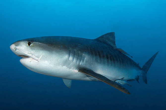
Marine Science News 2018
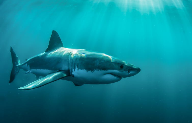
Some sharks have declined by 92% in the past half-century off Queensland’s coast
There has been a striking decline in the number of large sharks caught off Queensland’s coast over the past 50 years, suggesting that populations have declined dramatically.
Our study, published today in the journal Communications Biology, used historical data from the Queensland Shark Control Program.
Catch numbers of large apex sharks (hammerheads, tigers and white sharks) declined by 74-92%, and the chance of catching no sharks at any given beach per year has increased by as much as seven-fold.
Coinciding with ongoing declines in numbers of sharks in nets and drum lines, the probability of recording mature male and females has declined over the past two decades.
Our discovery is at odds with recent media reports of “booming” shark numbers reaching “plague” along our coastlines. The problem with those claims is that we previously had little idea of what the “natural” historical shark population would have been.
Why is the decline of sharks on the Queensland coastline a cause for concern? Large apex sharks have unique roles in coastal ecosystems, preying on weak and injured turtles, dolphins and dugongs, actively scavenging on dead whale carcasses, and connecting coral reefs, seagrass beds and coastal ecosystems.
Australia’s mixed view on sharks
As a nation, Australia has a long history with sharks. Some of the oldest stories in the world were written by the indigenous Yanyuwa people in the Northern Territory some 40,000 years ago, describing how the landscape of their coastal homeland was created by tiger sharks.
European settlers in the late 18th and early 19th centuries further described Australian coastlines as being “chock-full of sharks”, and upon visiting Sydney in 1895, the US author Mark Twain remarked:
The government pays a bounty of the shark; to get the bounty the fishermen bait the hook or the seine with agreeable mutton; the news spreads and the sharks come from all over the Pacific Ocean to get the free board. In time the shark culture will be one of the most successful things in the colony.
With the rise of Australian beach and surf culture, and the growing population density in coastal communities in the mid-20th century, increasing numbers of unprovoked fatal encounters with sharks occurred along the Queensland and New South Wales coastlines.
White sharks were extensively targeted and killed in “game fishing” tournaments, and harmless grey nurse sharks were hunted almost to extinction through recreational spearfishing in the 1950s and 1960s.
Yet despite this long history of shark exploitation, the historical baseline populations of sharks off Australia’s east coast were largely unknown.

Through mesh nets and baited drumlines, the Queensland Shark Control Program targets large sharks, with the aim of reducing local populations and minimise encounters between sharks and humans. Records of shark catches dating back as far as the 1960s provide a unique window into the past on Queensland beaches.
While we will never know exactly how many sharks roamed these waters more than half a century ago, the data points to radical changes in our coastal ecosystems since the 1960s.
The exact causes of declining shark numbers are difficult to pinpoint, largely because of a lack of detailed records from commercial or recreational fisheries before the 2000s. The Queensland government also acknowledges that the program itself has a direct impact on shark populations by selectively removing large, reproductively mature sharks from the population.
The data indicates that two hammerhead species – the scalloped and great hammerheads, both of which are listed as globally endangered – have declined by as much as 92% in Queensland over the past half century.
Similarly, the once-abundant white sharks have also shown no sign of recovery, despite a complete ban on commercial and recreational fishing in Queensland, implemented more than two decades ago.
The idea that shark populations are reaching “plague” proportions in recent years may represent a classic case of shifting baseline syndrome. Using shark numbers from recent history as a baseline may give a false perception that populations are “exploding”, whereas records from fifty years ago indicate that present day numbers are a fraction of what they once were.
Our results indicate that large shark species are becoming increasingly rare along Australia’s coastline. We should not be concerned about a “plague” of sharks, but rather the opposite: the fact
that previously abundant apex shark species are increasingly at risk.![]()
George Roff, Postdoctoral Research Fellow, The University of Queensland and Christopher Brown, Research Fellow, Australian Rivers Institute, Griffith University
This article is republished from The Conversation under a Creative Commons license. Read the original article.
14 December 2018
Explainer: how the Antarctic Circumpolar Current helps keep Antarctica frozen
The Antarctic Circumpolar Current, or ACC, is the strongest ocean current on our planet. It extends from the sea surface to the bottom of the ocean, and encircles Antarctica.
It is vital for Earth’s health because it keeps Antarctica cool and frozen. It is also changing as the world’s climate warms. Scientists like us are studying the current to find out how it might affect the future of Antarctica’s ice sheets, and the world’s sea levels.
The ACC carries an estimated 165 million to 182 million cubic metres of water every second (a unit also called a “Sverdrup”) from west to east, more than 100 times the flow of all the rivers on Earth. It provides the main connection between the Indian, Pacific and Atlantic Oceans.
The tightest geographical constriction through which the current flows is Drake Passage, where only 800 km separates South America from Antarctica. While elsewhere the ACC appears to have a broad domain, it must also navigate steep undersea mountains that constrain its path and steer it north and south across the Southern Ocean.
What is the Antarctic Circumpolar Current?
A satellite view over Antarctica reveals a frozen continent surrounded by icy waters. Moving northward, away from Antarctica, the water temperatures rise slowly at first and then rapidly across a sharp gradient. It is the ACC that maintains this boundary.
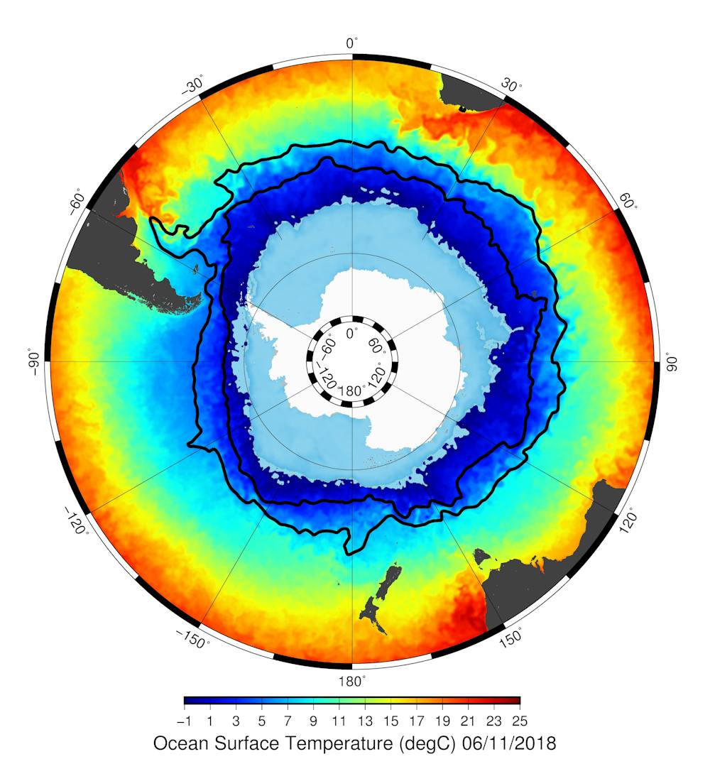
The ACC is created by the combined effects of strong westerly winds across the Southern Ocean, and the big change in surface temperatures between the Equator and the poles.
Ocean density increases as water gets colder and as it gets more salty. The warm, salty surface waters of the subtropics are much lighter than the cold, fresher waters close to Antarctica. We can imagine that the depth of constant density levels slopes up towards Antarctica.
The westerly winds make this slope steeper, and the ACC rides eastward along it, faster where the slope is steeper, and weaker where it’s flatter.
Fronts and bottom water
In the ACC there are sharp changes in water density known as fronts. The Subantarctic Front to the north and Polar Front further south are the two main fronts of the ACC (the black lines in the images). Both are known to split into two or three branches in some parts of the Southern Ocean, and merge together in other parts.
Scientists can figure out the density and speed of the current by measuring the ocean’s height, using altimeters. For instance, denser waters sit lower and lighter waters stand taller, and differences between the height of the sea surface give the speed of the current.
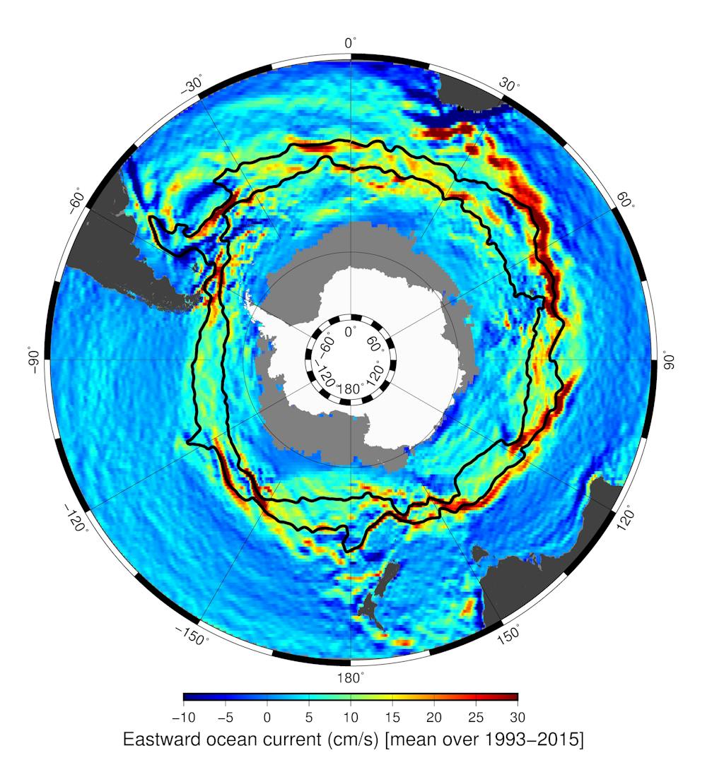
The path of the ACC is a meandering one, because of the steering effect of the sea floor, and also because of instabilities in the current.
The ACC also plays a part in the meridional (or global) overturning circulation, which brings deep waters formed in the North Atlantic southward into the Southern Ocean. Once there it becomes known as Circumpolar Deep Water, and is carried around Antarctica by the ACC. It slowly rises toward the surface south of the Polar Front.
Once it surfaces, some of the water flows northward again and sinks north of the Subarctic Front. The remaining part flows toward Antarctica where it is transformed into the densest water in the ocean, sinking to the sea floor and flowing northward in the abyss as Antarctic Bottom Water. These pathways are the main way that the oceans absorb heat and carbon dioxide and sequester it in the deep ocean.
Changing current
The ACC is not immune to climate change. The Southern Ocean has warmed and freshened in the upper 2,000 m. Rapid warming and freshening has also been found in the Antarctic Bottom Water, the deepest layer of the ocean.
Waters south of the Polar Front are becoming fresher due to increased rainfall there, and waters to the north of the Polar Front are becoming saltier due to increased evaporation. These changes are caused by human activity, primarily through adding greenhouse gases to the atmosphere, and depletion of the ozone layer. The ozone hole is now recovering but greenhouse gases continue to rise globally.
Winds have strengthened by about 40% over the Southern Ocean over the past 40 years. Surprisingly, this has not translated into an increase in the strength of the ACC. Instead there has been an increase in eddies that move heat towards the pole, particularly in hotspots such as Drake Passage, Kerguelen Plateau, and between Tasmania and New Zealand.
We have observed much change already. The question now is how this increased transfer of heat across the ACC will impact the stability of the Antarctic ice sheet, and consequently the rate of
global sea-level rise.![]()
Helen Phillips, Senior Research Fellow, Institute for Marine and Antarctic Studies, University of Tasmania; Benoit Legresy, , CSIRO, and Nathan Bindoff, Professor of Physical Oceanography, Institute for Marine and Antarctic Studies, University of Tasmania
This article is republished from The Conversation under a Creative Commons license. Read the original article.
Scientists studying ocean productivity have uncovered a volcanic lost world teeming with marine life off the Tasmanian coast.

The lost world was uncovered during detailed seafloor mapping by CSIRO research vessel Investigator while on a 25-day research voyage led by scientists from the Australian National University (ANU). The mapping has revealed, for the first time, a diverse chain of volcanic seamounts located in deep water about 400 km east of Tasmania. The seamounts tower up to 3000 m from the surrounding seafloor but the highest peaks are still far beneath the waves, at nearly 2000 m below the surface. Dr Tara Martin, from the CSIRO mapping team, said the mapping offered a window into a previously unseen and spectacular underwater world.
“Our multibeam mapping has revealed in vibrant detail, for the first time, a chain of volcanic seamounts rising up from an abyssal plain about 5000m deep, Dr Martin said. "The seamounts vary in size and shape, with some having sharp peaks while others have wide flat plateaus, dotted with small conical hills that would have been formed by ancient volcanic activity. “Having detailed maps of such areas is important to help us better manage and protect these unique marine environments, and provides a stepping stone for future research.
“This is a very diverse landscape and will undoubtedly be a biological hotspot that supports a dazzling array of marine life,” she said. Ship data collected during the voyage revealed spikes in ocean productivity over the chain of seamounts, with increased phytoplankton activity and marine animal observations in the area.
Dr Eric Woehler from BirdLife Tasmania, who was on Investigator with a team conducting seabird and marine mammal surveys, was astounded by the amount of life they saw above the seamounts.

“While we were over the chain of seamounts, the ship was visited by large numbers of humpback and long-finned pilot whales,” Dr Woehler said. “We estimated that at least 28 individual humpback whales visited us on one day, followed by a pod of 60-80 long-finned pilot whales the next. We also saw large numbers of seabirds in the area including four species of albatross and four species of petrel.”
“Clearly, these seamounts are a biological hotspot that supports life, both directly on them, as well as in the ocean above,” he said.
Research indicates that seamounts may be vital stopping points for some migratory animals, especially whales. Whales may use these seafloor features as navigational aids during their migration. “These seamounts may act as an important signpost on an underwater migratory highway for the humpback whales we saw moving from their winter breeding to summer feeding grounds,” Dr Woehler said. “Lucky for us and our research, we parked right on top of this highway of marine life!” The life and origin of the seamounts will be further studied later this year when Investigator returns to the region for two further research voyages departing in November and December. A range of surveys will be conducted on these voyages, including capturing high resolution video of marine life on the seamounts using deep water cameras, and collecting rock samples to better understand their formation and origin. Dr Woehler will be on the first of these voyages and expects further surprises on the return visit. “We expect that these seamounts will be a biological hotspot year round, and the summer visit will give us another opportunity to uncover the mysteries of the marine life they support,” said Dr Woehler.

Research vessel Investigator is Australia’s only research vessel dedicated to blue-water research, and is owned and operated by CSIRO – Australia’s national science agency. The vessel conducts research year round, and is made available to Australian researchers and their international collaborators.
11 October 2018, First published by CSIRO, at: https://www.csiro.au/en/News/News-releases/2018/Scientists-uncover-volcanic-lost-world
SharkSpotter combines AI and drone technology to spot sharks and aid swimmers on Australian beaches
Four tiger sharks have now been captured and killed following two separate attacks off the coast of North Queensland last week. Despite being relatively rare, shark attacks – or the threat of attacks – not only disrupt recreational beach activities, but can affect associated tourist industries.
Shark nets are a common solution to preventing shark attacks on Australian beaches, but they pose dangers to marine ecosystems.
Seeking a cost-effective way to monitor beach safety over large areas, we have developed a system called SharkSpotter. It combines artificial intelligence (AI), computing power, and drone technology to identify and alert lifesavers to sharks near swimmers.
SharkSpotter was named the national AI or Machine Learning Innovation of the Year at the Australian Information industry Association (AIIA) annual iAwards this month.
The project is a collaboration between the University of Technology Sydney and The Ripper Group, which is pioneering the use of drones – called “Westpac Little Ripper Lifesavers” – in the search and rescue movement in Australia.
A shark spotting drone
SharkSpotter can detect sharks and other potential threats using real-time aerial imagery. The system analyses streaming video from a camera attached to a drone (an unmanned aerial vehicle, or UAV) to monitor beaches for sharks, issue alerts, and conduct rescues.
Developed using machine learning techniques known as “deep learning”, the SharkSpotter system receives streaming imagery from the drone camera and attempts to identify all objects in the scene. Once valid objects are detected, they are put into one of 16 categories: shark, whale, dolphin, rays, different types of boats, surfers, and swimmers.
If a shark is detected, SharkSpotter provides both a visual indication on the computer screen and an audible alert to the operator. The operator verifies the alert and sends text messages from the SharkSpotter system to the Surf Life Savers for further action.
In an emergency, the drone is equipped with a lifesaving flotation pod together with an electronic shark repellent that can be dropped into the water in cases where swimmers are in severe distress, trapped in a rip, or if there are sharks close by.
A new age of accuracy
The development of SharkSpotter involved several stages.
Among the most time-consuming tasks was collecting and annotating the necessary data. The data were collected by The Ripper Group by flying a drone with a camera attached to it above different Australian beaches.
We then manually annotated each video to indicate the specific location of sharks and other objects. The video frames and the annotations were then used to train the deep learning algorithm to correctly identify and classify objects.
These advanced machine learning techniques significantly improve aerial detection to more than 90% accuracy. That’s much better than conventional techniques such as helicopters with human spotters (17.1%) and fixed-wing aircraft spotters (12.5%).
We tested the system at different Australian beaches to determine the varying parameters, such as camera resolution, height above sea level (which can affect the vision clarity of drones), speed and flight duration.
After successful trials and fine-tuning of the system, SharkSpotter was used across a dozen popular beaches in New South Wales and Queensland last summer.
The system was developed to help Surf Life Savers monitor the beach more effectively – as opposed to replacing them – and has been received positively by end-users and communities alike, according to a survey conducted by The Ripper Group.
Saving lives
In January 2018, the Westpac Little Ripper Lifesaver was used to rescue two young swimmers caught in a rip at Lennox Head, NSW.
The drone flew down the beach some 800 metres from the lifeguard station, and a lifesaving flotation pod was dropped from the drone. The complete rescue operation took 70 seconds.
We believe SharkSpotter is a win-win for both marine life and beachgoers. From a technology perspective, it has demonstrated how to detect moving objects in a complex, dynamic marine environment from a fast-moving drone.
This unique technology combines dynamic video image processing AI and advanced drone technology to creatively address the global challenge of ensuring safe beaches, protecting marine environments, and enhancing tourism.
The authors would like to acknowledge the contributions of Dr Paul Scully Power, co-founder of The Ripper Group, who partnered in the development of SharkSpotter.
![]()
Nabin Sharma, Senior Lecturer, UTS School of Software, University of Technology Sydney and Michael Blumenstein, Associate Dean Research (Strategy and Management) at the University of Technology Sydney, University of Technology Sydney
This article is republished from The Conversation under a Creative Commons license.
28 September 2018
Scientists have been drilling into the ocean floor for 50 years – here’s what they’ve found so far
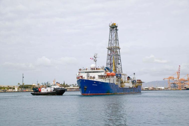
It’s stunning but true that we know more about the surface of the moon than about the Earth’s ocean floor. Much of what we do know has come from scientific ocean drilling – the systematic collection of core samples from the deep seabed. This revolutionary process began 50 years ago, when the drilling vessel Glomar Challenger sailed into the Gulf of Mexico on August 11, 1968 on the first expedition of the federally funded Deep Sea Drilling Project.
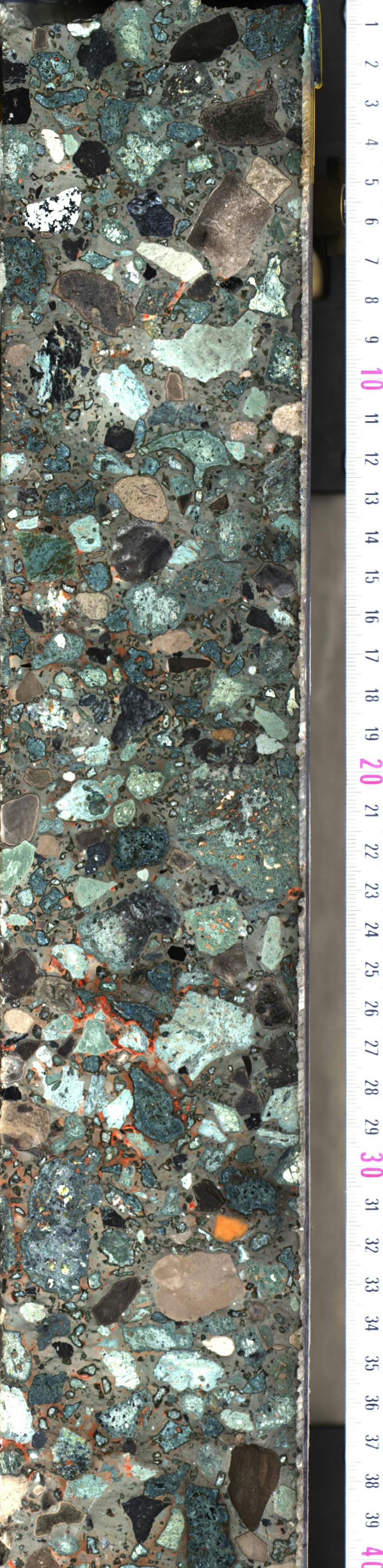
I went on my first scientific ocean drilling expedition in 1980, and since then have participated in six more expeditions to locations including the far North Atlantic and Antaractica’s Weddell Sea. In my lab, my students and I work with core samples from these expeditions. Each of these cores, which are cylinders 31 feet long and 3 inches wide, is like a book whose information is waiting to be translated into words. Holding a newly opened core, filled with rocks and sediment from the Earth’s ocean floor, is like opening a rare treasure chest that records the passage of time in Earth’s history.
Over a half-century, scientific ocean drilling has proved the theory of plate tectonics, created the field of paleoceanography and redefined how we view life on Earth by revealing an enormous variety and volume of life in the deep marine biosphere. And much more remains to be learned.
Technological innovations
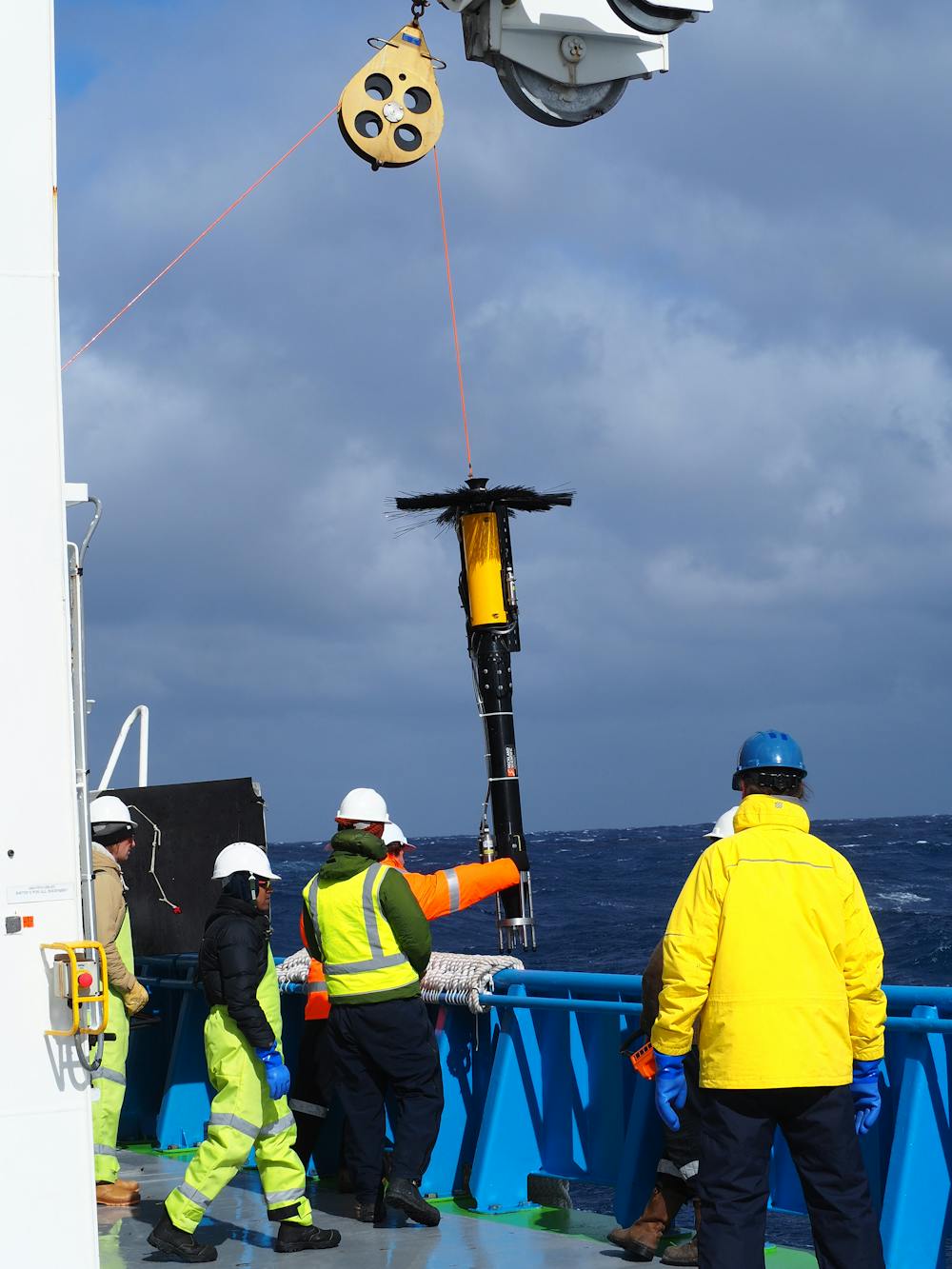
Two key innovations made it possible for research ships to take core samples from precise locations in the deep oceans. The first, known as dynamic positioning, enables a 471-foot ship to stay fixed in place while drilling and recovering cores, one on top of the next, often in over 12,000 feet of water.
Anchoring isn’t feasible at these depths. Instead, technicians drop a torpedo-shaped instrument called a transponder over the side. A device called a transducer, mounted on the ship’s hull, sends an acoustic signal to the transponder, which replies. Computers on board calculate the distance and angle of this communication. Thrusters on the ship’s hull maneuver the vessel to stay in exactly the same location, countering the forces of currents, wind and waves.
Another challenge arises when drill bits have to be replaced mid-operation. The ocean’s crust is composed of igneous rock that wears bits down long before the desired depth is reached.
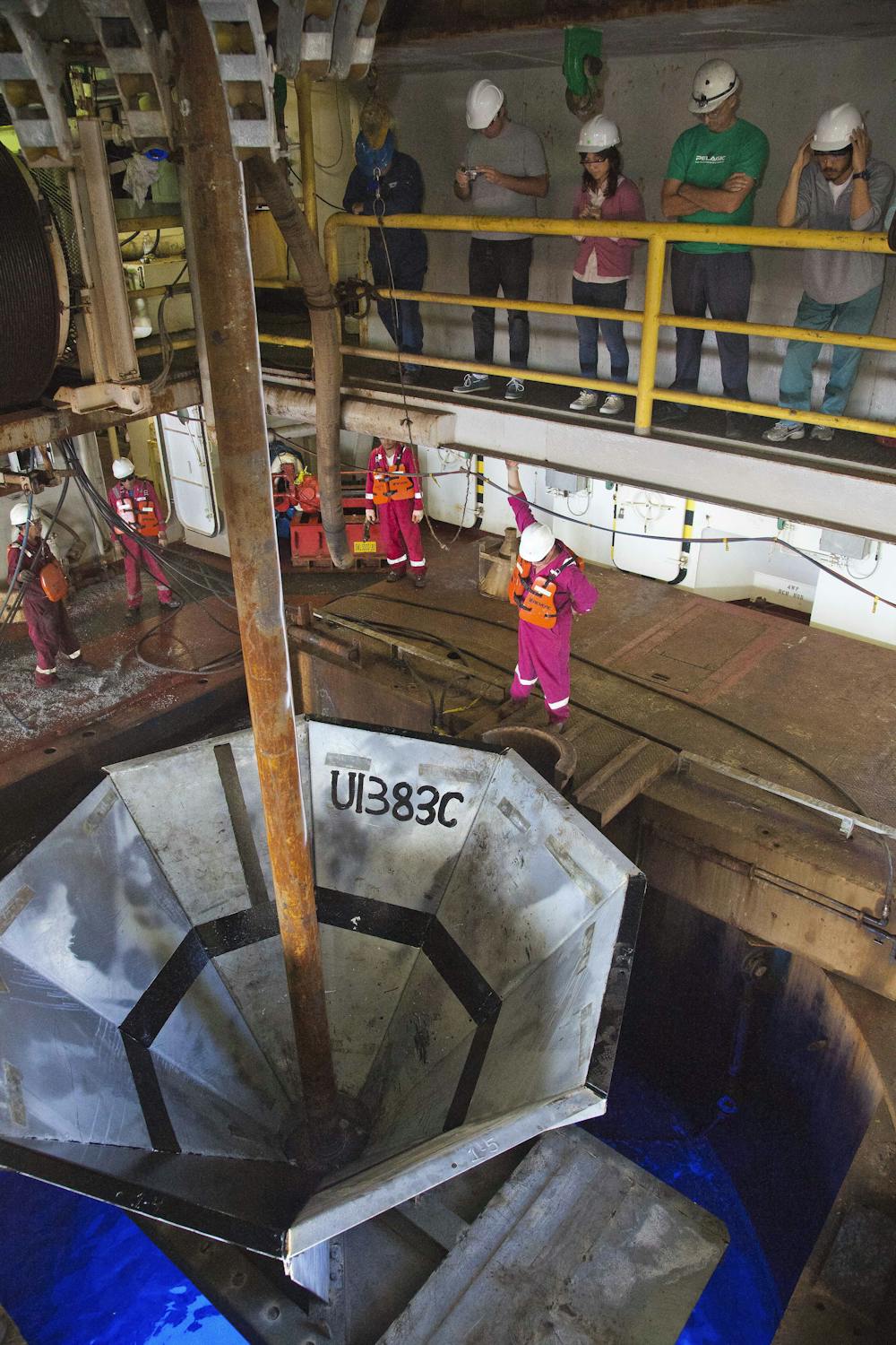
When this happens, the drill crew brings the entire drill pipe to the surface, mounts a new drill bit and returns to the same hole. This requires guiding the pipe into a funnel shaped re-entry cone, less than 15 feet wide, placed in the bottom of the ocean at the mouth of the drilling hole. The process, which was first accomplished in 1970, is like lowering a long strand of spaghetti into a quarter-inch-wide funnel at the deep end of an Olympic swimming pool.
Confirming plate tectonics
When scientific ocean drilling began in 1968, the theory of plate tectonics was a subject of active debate. One key idea was that new ocean crust was created at ridges in the seafloor, where oceanic plates moved away from each other and magma from earth’s interior welled up between them. According to this theory, crust should be new material at the crest of ocean ridges, and its age should increase with distance from the crest.
The only way to prove this was by analyzing sediment and rock cores. In the winter of 1968-1969, the Glomar Challenger drilled seven sites in the South Atlantic Ocean to the east and west of the Mid-Atlantic ridge. Both the igneous rocks of the ocean floor and overlying sediments aged in perfect agreement with the predictions, confirming that ocean crust was forming at the ridges and plate tectonics was correct.
Reconstructing earth’s history
The ocean record of Earth’s history is more continuous than geologic formations on land, where erosion and redeposition by wind, water and ice can disrupt the record. In most ocean locations sediment is laid down particle by particle, microfossil by microfossil, and remains in place, eventually succumbing to pressure and turning into rock.
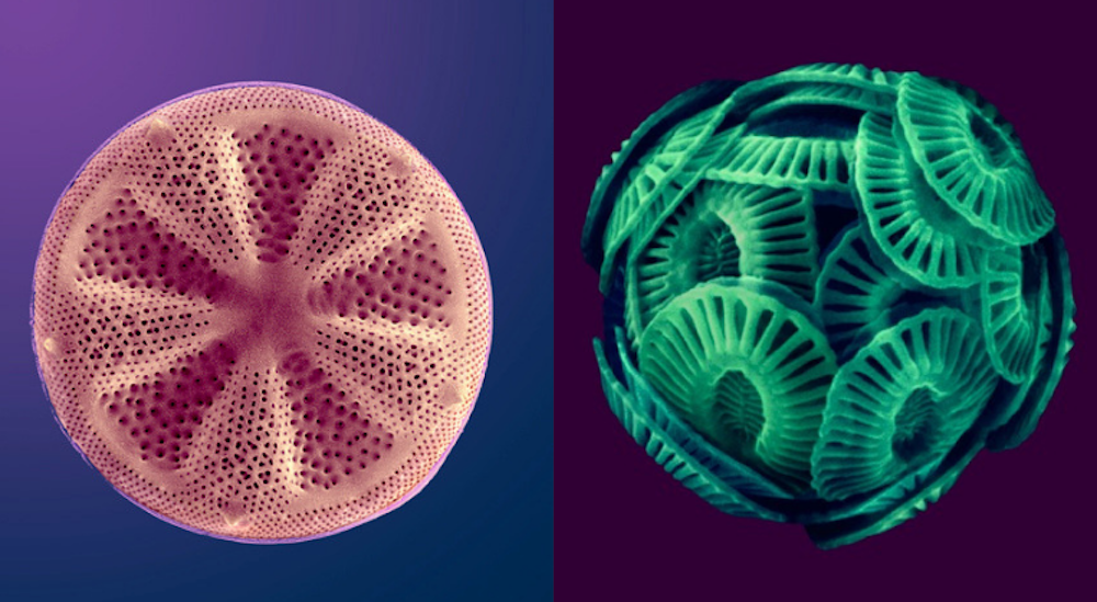
Microfossils (plankton) preserved in sediment are beautiful and informative, even though some are smaller than the width of a human hair. Like larger plant and animal fossils, scientists can use these delicate structures of calcium and silicon to reconstruct past environments.
Thanks to scientific ocean drilling, we know that after an asteroid strike killed all non-avian dinosaurs 66 million years ago, new life colonized the crater rim within years, and within 30,000 years a full ecosystem was thriving. A few deep ocean organisms lived right through the meteorite impact.
Ocean drilling has also shown that ten million years later, a massive discharge of carbon – probably from extensive volcanic activity and methane released from melting methane hydrates – caused an abrupt, intense warming event, or hyperthermal, called the Paleocene-Eocene Thermal Maximum. During this episode, even the Arctic reached over 73 degrees Fahrenheit.
The resulting acidification of the ocean from the release of carbon into the atmosphere and ocean caused massive dissolution and change in the deep ocean ecosystem.
This episode is an impressive example of the impact of rapid climate warming. The total amount of carbon released during the PETM is estimated to be about equal to the amount that humans will release if we burn all of Earth’s fossil fuel reserves. Yet, an important difference is that the carbon released by the volcanoes and hydrates was at a much slower rate than we are currently releasing fossil fuel. Thus we can expect even more dramatic climate and ecosystem changes unless we stop emitting carbon.
Finding life in ocean sediments
Scientific ocean drilling has also shown that there are roughly as many cells in marine sediment as in the ocean or in soil. Expeditions have found life in sediments at depths over 8000 feet; in seabed deposits that are 86 million years old; and at temperatures above 140 degrees Fahrenheit.
Today scientists from 23 nations are proposing and conducting research through the International Ocean Discovery Program, which uses scientific ocean drilling to recover data from seafloor sediments and rocks and to monitor environments under the ocean floor. Coring is producing new information about plate tectonics, such as the complexities of ocean crust formation, and the diversity of life in the deep oceans.
This research is expensive, and technologically and intellectually intense. But only by exploring the deep sea can we recover the treasures it holds and better understand its beauty and
complexity.![]()
Suzanne O'Connell, Professor of Earth & Environmental Sciences, Wesleyan University
This article is republished from The Conversation under a Creative Commons license.
26 September 2018
Scientists make breakthrough in war against crown-of-thorns starfish
Researchers at the Australian Institute of Marine Science have made a significant breakthrough in the war against crown-of-thorns starfish, on the Great Barrier Reef.
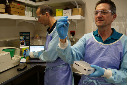
AIMS’ senior research leader Dr Sven Uthicke and biochemist Jason Doyle, along with echinoderm expert Dr Miles Lamare from the University of Otago, in New Zealand, have developed a cost effective method for detecting DNA of the coral-eating pest.
Dr Uthicke said the method would improve monitoring and early detection of the reef pest, also known as crown-of-thorns seastar, allowing reef managers to contain outbreaks sooner.
“It’s a genetic probe which we had developed to detect seastar larvae in plankton and we have been able to modify the method,” Dr Uthicke said. “We have worked on this for the past three years, and we have been able to adapt this to make it more sensitive to detect adult crown-of-thorns seastar.” Ecological monitoring has so far failed to detect early stages of an outbreak which has prevented timely intervention.
Dr Uthicke said the current method for detecting outbreaks were on-reef field surveys using divers but by the time these methods detect outbreaks, the outbreak is usually well established. “Standard monitoring techniques only identify about 5 per cent of the pest on reefs, but this new method will allow us to clearly identify whether greater numbers are present,” Dr Uthicke said. “It counts the number of gene copies in the sample of seawater from a reef using a novel technique called digital droplet PCR.”
During recent field work, using the probe on 11 reefs of the Great Barrier Reef, crown-of-thorns starfish DNA was detectable on those suffering outbreaks. In contrast, crown-of-thorns starfish DNA was absent from ‘post-outbreak’ reefs after populations collapsed, and from ‘pre-outbreak’ reefs.

The fourth wave of outbreaks since the 1960s started around 2010 on Australia’s far northern Great Barrier Reef and has seen the significant loss of coral cover to the voracious appetite of the starfish, making it a major contributor to the coral reef crisis. This outbreak has spread as far south as Townsville along the Great Barrier Reefs, and is expected to continue south. This research project was partly funded by The National Environmental Science Program (NESP), the Great Barrier Reef Marine Park Authority and philanthropist Ian Potter Foundation.
The paper ‘eDNA detection of corallivorous seastar (Acanthaster cf. solaris) outbreaks on the Great Barrier Reef using digital droplet PCR’ is available online in the journal Coral Reefs.
18 September 2018, Australian Institute of Marine Science, 2018
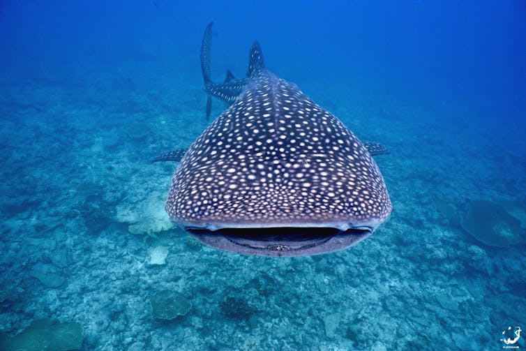
Whale sharks gather at a few specific locations around the world – now we know why
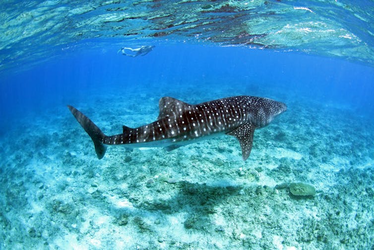
The whale shark is the largest fish in the world, but much of its lifecycle remains shrouded in mystery. These gentle giants gather in just a handful of places around the globe – something which has long baffled scientists – but our new research has started to explain why. Better understanding of whale shark movements could help prevent further population loss in a species that has already experienced a 63% population decline over the past 75 years.
When swimming solo, the whale shark, which can grow up to 18.8 metres in length and 34 tons in weight, travels all over the world. Recently, a group of scientists tracked the remarkable journey of one whale shark across the Pacific from Panama to the Philippines. At more than 12,000 miles it proved to be one of the longest migrations ever recorded.
Yet whale sharks are known to come together at just a few specific locations around the world. Anything from ten to 500 whale sharks may gather at any one time in areas off the coasts of Australia, Belize, the Maldives, Mexico and more.
Approximately 20 hotspots have been identified – mere pinpricks in the vastness of the world’s oceans – but we don’t know what exactly attracts the whale sharks to them. In some cases the sites are linked to a specific biological phenomenon – such as the spawning of land crabs at Christmas Island in the Indian Ocean, which provides whale sharks with the seasonal equivalent of a Christmas feast. Our new research aimed to discover whether there was something else that united the places where these giants of the ocean hang out.
It’s all about bathymetry
The physical features of these spots – known as their bathymetry – have been shown to influence gathering points in other marine species. So in collaboration with the Maldives Whale Shark Research Programme, we decided to investigate whether it drives whale shark gatherings in the same way.
Our new global study shows that whale sharks congregate in specific areas of shallow water, next to steep slopes that quickly give way to areas much deeper water (usually between 200 metres and 1,000 metres).
We identified three main reasons. First, the deep water is used by whale sharks for feeding. Studies have shown the sharks diving to depths of almost 2 kilometres (1,928 metres to be precise) to feed on zooplankton and squid.
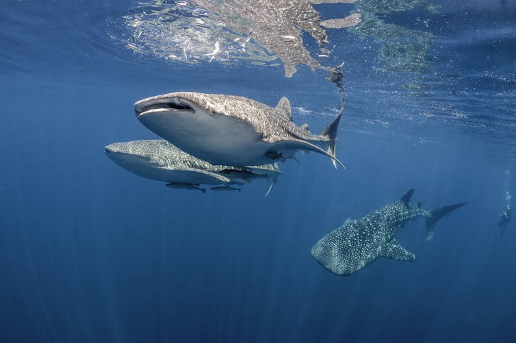
Second, the steep slopes are known to bring nutrients up to the surface from the deep, which in turn increases the abundance of plankton and attracts large numbers of filter feeding species. And finally, in shallow water, as well as feeding on coral and fish spawn, the sharks are able to thermoregulate, warming themselves back up after their dives into deep water which gets as cold as 4℃.
Valuable but vulnerable
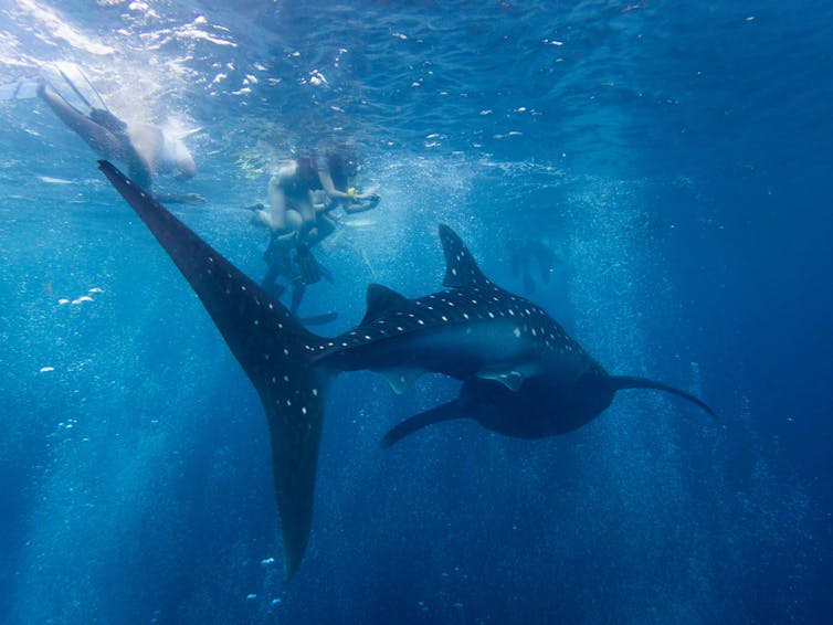
If you’ve ever seen or swum with a whale shark, it was most likely in one of these relatively shallow aggregation areas. Knowing where these hotspots are has provided local communities with a windfall from ecotourism. In the Maldives alone, economic benefits from whale shark-related activities were estimated at US$9.4m per year. Whale sharks are worth a lot more alive than dead – and with many of these meeting points in developing countries, the income is invaluable.
But with the increasing pressures of tourism comes new dangers for the sharks. Crowds of snorkelers and tourist vessels are increasingly disturbing the whale shark’s waters, and – more worryingly – risk potentially fatal strikes by boats. To protect these beautiful creatures and continue to reap the rewards of ecotourism, we recommend that marine protected areas should be set up around whale shark gatherings and codes of practice be followed when interacting with them.
Deep mysteries remain
These discoveries have narrowed down some of the key reasons why whale sharks congregate where they do, but many mysteries remain. Do individuals travel between these hotspots? Coastal gatherings are predominately made up of immature male sharks, usually still just four or five metres long. So where are all the girls? And where do whale sharks mate and give birth? Mating and pupping have never been seen in the wild – but, intriguingly, up to 90% of the whale sharks passing through the Galapagos marine reserve are female and thought to be pregnant.
![]() Could this be a key labour ward for the
world’s whale sharks? Last year a BBC film crew at the Galapagos attempted to follow a pregnant female in a
submersible to watch it give birth, but to no avail. That’s one secret that the depths are keeping for now.
Could this be a key labour ward for the
world’s whale sharks? Last year a BBC film crew at the Galapagos attempted to follow a pregnant female in a
submersible to watch it give birth, but to no avail. That’s one secret that the depths are keeping for now.
Joshua Copping, PhD Candidate in Environmental Sciences, University of Salford and Bryce Stewart, Lecturer in Marine Ecosystem Management, University of York
This article was originally published on The Conversation. Read the original article.
nbsp7 July 2018
FactFile: the facts on shark bites and shark numbers
Are there more sharks in Australian waters than there used to be, and are interactions between humans and shark increasing? Some Australian politicians have claimed that to be the case.
Let’s look at the research.
The most reputable source for shark incident data in Australia is the Australian Shark Attack file, which is collated at Sydney’s Taronga Zoo.
The map below, created by The Conversation using data from the Australian Shark Attack File, shows incidents between sharks and humans in Australia between 1997 and 2017.
You can use the filter buttons in the map to explore the data by year, season, the type of injury, the type of shark involved, the type of incident – or a combination of all the filters. Press the ‘show all’ button to reset the search.
The number of recorded encounters between sharks and humans in Australia increased modestly between 1997 and 2017, but the reason for this is unclear. Over those two decades, the Australian population increased by 33%, but that alone doesn’t explain the increase in recorded shark encounters.
Correcting for the growth in human population in Australia, the data show that between 1997 and 2017:
- incidents resulting in injury increased by 1.59%
- incidents without injury increased by 0.36%, and
- fatalities increased by 0.07%.
Encounters between humans and sharks are extremely variable over time, and difficult to predict. The increases in recorded incidents between 1997 and 2017 are relatively small, and may be explained by factors not related to shark populations – such as increases in the reporting of shark encounters, or increasing beach use.
Are there more sharks off the Australian coast?
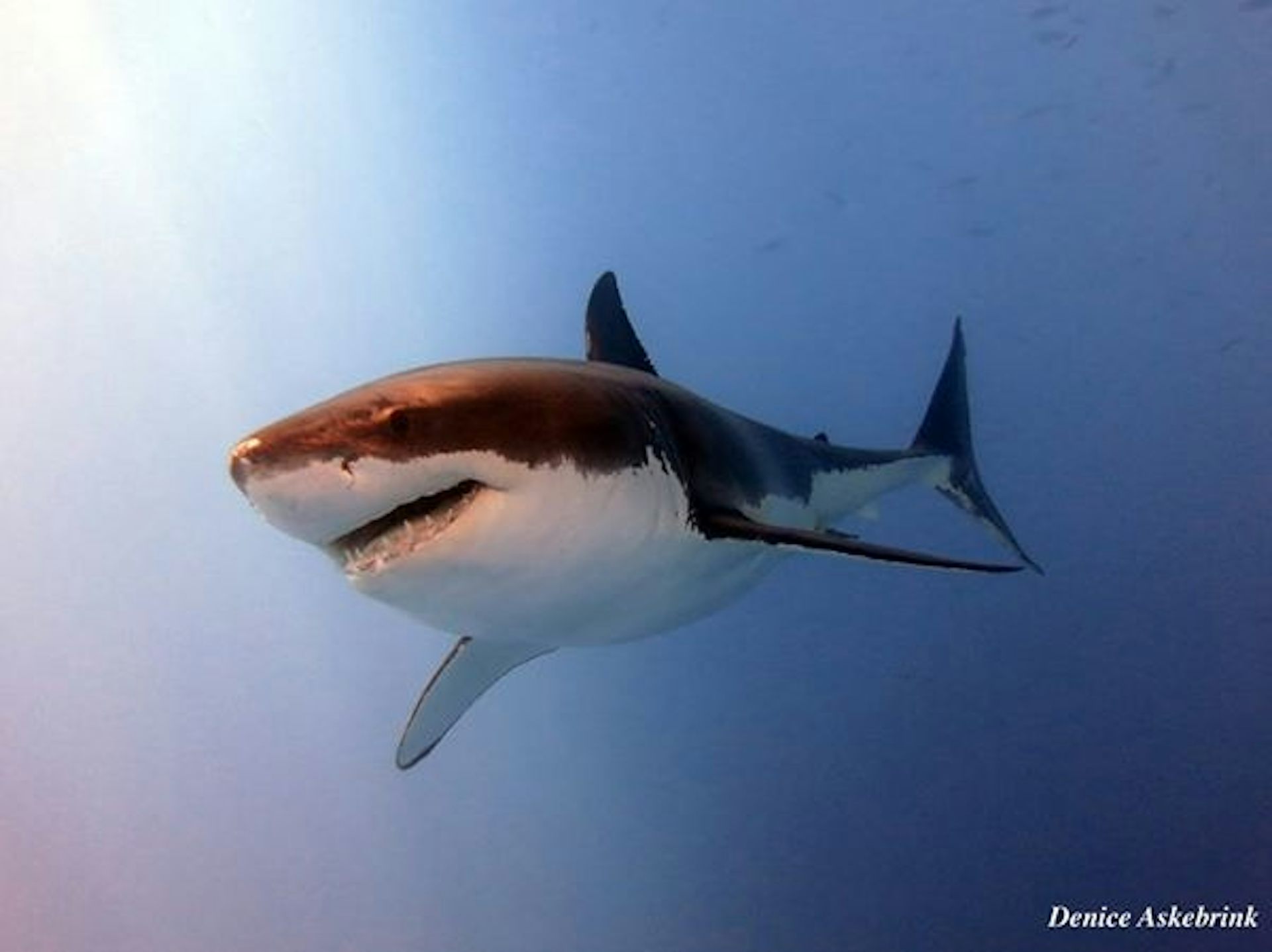
White Sharks (formerly Great White Sharks) are recorded as being responsible for 28 of the 36 fatal shark encounters in Australian waters between 1997 and 2017, and are the primary target of shark mitigation strategies of the Western Australian, New South Wales and Queensland governments.
So, has there been an increase in the number of White Sharks in Australian waters?
Estimating population numbers in the marine environment is difficult, especially for long-lived migratory species like White Sharks.
However, there is no evidence that White Sharks numbers are on the rise, either in Western Australia or along the Eastern coast. Despite targeted conservation efforts, the available research show stable or slightly declining numbers in these populations.
There are two distinct populations of White Sharks off Australian coasts – one to the west, and another to the east of Bass Strait, which separates Tasmania from mainland Australia. The eastern population includes New Zealand White Sharks.
Recent work by the CSIRO through the National Environmental Science Program’s Marine Biodiversity Hub using innovative DNA analysis has provided us with the most detailed and reliable estimates of population size we have for this species.
The CSIRO study shows there has been a slight decline in adult White Shark populations since the year 2000.
Current adult abundance for the eastern Australasian population is estimated at 750, with an uncertainty range of 470 to 1,030. The southern-western adult population is roughly double the size, estimated at 1,460, with an uncertainty range of 760 to 2,250.
Including the available information about juvenile White Sharks, estimates of total size for the eastern population in 2017 was 5,460, with an uncertainty range of 2,909 to 12,802.
It’s difficult to detect population trends with White Sharks because of the length of time it takes juveniles to reach maturity – around 15 years. As protection of White Sharks began in the late 1990s, any changes in abundance would only be starting to appear in current populations.
How else can we measure White Shark populations?
The traditional way of measuring shark and fish populations is by examining catches in commercial fisheries over long time periods. By correcting for the level of fishing effort – which is done by looking at things like the number of nets, hooks and tows deployed by fishermen – scientists can assume that changes in the “catchability” of sharks is related to their abundance.
But due to the relative rarity of catches of White Sharks by fishing vessels, this approach is less reliable for this species than the more recent genetic studies conducted by the CSIRO and outlined above.
Western Australia has a detailed measure of White Shark numbers assessed by catch data. A report published by the Western Australian Department of Fisheries in 2016 attempted to model changes in the southern-western Australian White Shark population since the late 1930s. The authors outlined four different plausible scenarios, none of which suggested a continuous increase in the number of White Sharks.
In New South Wales, there has been a cluster of shark bites in recent years. Data from the NSW Shark Meshing (Bather Protection) Program, managed by the NSW Department of Primary Industries, show a recent increase in White Sharks caught in nets placed near ocean beaches.
But when it comes to thinking about shark populations, we should not assume that these two facts are related. It’s important to remember that just because two things may correlate, it doesn’t mean that one caused the other.
These patterns could mean that the animals are coming closer to shore, rather than a population increase (or decrease).
Shark and human interactions: what factors are at play?
A 2016 paper examined six global shark bite “hotspots” – the United States, South Africa, Australia, Brazil, Reunion Island and the Bahamas – and concluded that when it comes to encounters between sharks and humans, there are a range of causes at play.
These include:
- rises in human population
- habitat destruction/modification
- changes in water quality
- climate change
- changing weather patterns, and
- the distribution/abundance of prey.
The authors also noted that shark encounters appear to happen in clusters. For example, 2009 saw a spike in shark encounters off the New South Wales coast. This coincided with an increase in beach attendance and beach rescues during what was an unusually warm summer for south-east Australia.
A 2011 paper highlighted the popularity of water sports as a factor contributing to increased human-shark encounters. More people are taking part in water sports, and improvements in wetsuit technology mean that people are in the water for longer throughout the year.
However, there is limited information on the number of people who use Australian beaches, so this explanation needs to be further studied.
 It’s vital that any strategies put in place to reduce the
number of unprovoked encounters between humans and sharks in Australian waters are carefully considered, and based on the best available research.
It’s vital that any strategies put in place to reduce the
number of unprovoked encounters between humans and sharks in Australian waters are carefully considered, and based on the best available research.
Jane Williamson, Associate Professor in Marine Ecology, Macquarie University and Vincent Raoult, Postdoctoral fellow, University of Newcastle
This article was originally published on The Conversation. Read the original article.
27 February 2018
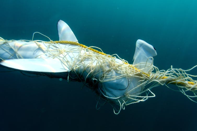
Sea Shepherd calls for Shark Net Removal in Queensland

After several sightings of protected Humpback whales migrating along the east coast over the past two weeks, NSW Department of Primary Industries Minister Niall Blair has announced the second NSW North Coast net trial will come to an end.
NSW is also removing shark nets from their other 51 sites for the whale migration season. Whilst NSW is removing gear to prevent whale entanglements, Queensland continues at the peril of these majestic marine mammals. Please sign these petitions to demonstrate your support for marine animals.
Sea Shepherd welcomes the NSW Government announcement that ended the northern NSW shark net trial which was putting these ocean giants at too great a risk. Whale tourism is an important industry in Queensland with some of the finest whale watching tours available in centres from the Gold Coast to Hervey Bay and to Cairns and Port Douglas. Locals and tourists want to see these animals swimming freely without the risk of entanglement.
Sea Shepherd's Operation Apex Harmony team saw possibly 11 entanglements in Queensland Shark Control Program gear last year with a whale calf killed at Kurrawa in a shark net. Fellow campaigner and marine scientist, CEO of Humpbacks and Highrises, Dr Olaf Meynecke said: “Our organisation has long campaigned for the replacement of the shark nets in the Gold Coast as they are a major risk to protected marine life including whales who use the bay as a resting and calving ground each year.
"NSW has removed shark nets whilst only a few kilometres across the border in the Gold Coast bay whale entanglements will continue. More than 1/3 of recorded Humpback whale incidents along the Queensland coastline are in fact due to the Queensland Shark Control Program and we urgently need to change the current practice in light of an increasing whale population. "Alternative methods are available that do not put the life of humans or whales in danger.” Sea Shepherd Australia's Managing Director Mr Hansen also stated: “Sea Shepherd is concerned for human safety. It is not a question of protecting human safety at cost to the marine environment. You can have both human safety and marine animal protection with the many non-lethal alternatives to nets and drum lines available right now.”
Originally published at: http://www.seashepherd.org.au/news-and-commentary/news/sea-shepherd-calls-for-shark-net-removal-in-queensland.html
4 May 2018
Help remove the shark nets for good in Queensland
Help remove the shark nets for good in New South Wales
4 things you didn’t know about white sharks

Given white sharks get the (sea)lion’s share of media attention, you may be surprised to learn that we don’t know a whole lot about them. Sure, we know some pretty cool stuff already: they give birth to live young, can swim over 60km an hour and are an apex predator. But because they swim huge distances and are lone travellers it’s hard to get to know them really well. Scientists love a challenge though, so, courtesy of their tireless efforts to study these great creatures, here are four facts you probably didn’t know.
There are two main populations of white shark in the Australasian region

Tagging data and genetic evidence suggests two populations of white sharks Carchardon carcharias (commonly known as the great white shark) exist in Australia: an eastern population ranging from Tasmania to central Queensland and across to New Zealand, and a southern-western population ranging from western Victoria to north-western Western Australia.
Until now, there were no reliable estimates of white shark population sizes in Australian waters
There’s a popular saying in the marine world: ‘counting fish is like counting trees, but you can’t see them and they move around all the time.’ Sounds impossible, right? Not for our scientists: in a world first we’ve used a unique combination of electronic tagging and tracking, collection of tissue samples, and a combined genetic and statistical technique called ‘close-kin mark recapture’ to estimate the Australian white shark populations. ‘Close-kin mark recapture’ means we compared the genetic data from juvenile white sharks to figure out how many shared a mother or father. This number can reveal the overall number of breeding adults: a smaller adult population means lots of half and full brothers and sisters, and vice versa. Through the juvenile’s DNA, we’re learning a whole lot about the adult population without having to track them down.
The only catch – you need to know where the cool kids hang (the nursery areas for juvenile white sharks) so you can tag them and collect samples. The eastern juveniles have a few choice locations but their southern-western counterparts are keeping tight-lipped about their favourite spots, meaning we couldn’t conduct the same study with them. Despite this, we were able to estimate the southern-western adult population size to be 1460 (with a range of between 760 and 2250).
But what of the eastern population? We estimate the total population to be 5,460 (with a range of between 2909 and 12,802). We’re not sure if this is historically high, low or somewhere in-between because we have nothing to compare it with, but at least we now have a starting point.
White sharks take a long time to mature
White sharks take a relatively long time to reach maturity — 12 to 15 years — which means they’re slow to reproduce. These are the badges of evolutionary honour a species gets to wear for being extremely successful. However, these same traits mean that if the number of mature white sharks dropped suddenly, the entire species could be under threat. Until now, we had no idea how many juvenile sharks survive to maturity, an important piece of the population puzzle. Another incredible thing our researchers have uncovered is the mortality rate of juvenile sharks in the eastern population. Using data from around 70 juvenile sharks fitted with an acoustic emitter we estimated that juvenile sharks had an annual survival rate of around 73 per cent.
More sharks in the water doesn’t mean more shark attacks
While it’s true the overall number of shark attacks has gradually increased in the past few decades in Australia, many different factors unrelated to shark numbers contribute to the overall increase in shark attacks. These include human population trends, changes in human population distribution and regional demographics, as well as variations in lifestyle and behaviour of people over time. However, clusters of shark attacks cannot be attributed to increases in human use of the ocean, or sudden increases in overall shark population size, because neither of these change over such short periods.
There are, for example, high human-use areas where white sharks are abundant but the incidence of shark attack is low. The drumline program in Western Australia revealed a significant number of tiger sharks present in coastal waters off Perth, yet no attacks have been attributed to this species in the area since 1925 according to the Australian Shark Attack file. Incidence and frequency of shark attacks may not relate directly to local shark abundance and cannot be used as a proxy for shark population trend.
So, what does all this new information mean? Now that we have a starting point for shark populations, we’ll be repeating the process over time to build population trends – a crucial step for developing effective policy outcomes for conservation and risk management.
Original article published https://blog.csiro.au/4-things-didnt-know-white-sharks/
9 February 2018
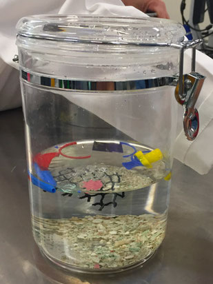
Tiny plastics are potentially dangerous for turtles too

Scientists from James Cook University (JCU) and the Australian Institute of Marine Science (AIMS) have developed a new method to study microplastics swallowed by sea turtles.
The new technique will help assess whether microplastics are as dangerous to turtles as larger pieces of plastic.
Recent estimates suggest there are more than 5 trillion pieces of plastic debris floating in the world's oceans, a figure which doesn’t include waste on beaches or the seafloor.
JCU’s Associate Professor Ellen Ariel said contamination of marine life by microplastics – pieces of plastic smaller than 5 mm in length - is poorly known and likely to be under-reported.
AIMS@JCU student Alexandra Caron, led the study. “As with bigger pieces of plastic, once swallowed, ingested microplastics may impact organisms physically as well as physiologically as they can leach associated plastic chemicals or other absorbed pollutants into the animal causing toxicity,” she said.
Sea turtles are at particular risk from plastics in the oceans because the seven species of marine turtles are already categorised as vulnerable to critically endangered.“They look for things like jellyfish to eat, and a piece of soft floating plastic can appear very similar. Plastic debris can also become entangled among green turtle food sources such as seagrass leaves and seaweed. Turtles don’t have the capacity to regurgitate, so plastic particles tend to be swallowed and accumulate in the gut,” said Associate Professor Ariel.
Under the supervision of AIMS marine chemist Dr. Cherie Motti the new method was applied. It involves a sequence of chemical treatments designed to separate out swallowed plastic particles from plant and animal food remains as well as any sediment the turtle has swallowed during feeding. “We examined the gut of two green turtles using this new method, and even with this small sample set, found seven microplastics consisting of two plastic paint chips and five synthetic fabric particles. That’s in addition to also finding 4.5 m of nylon line and some soft plastic pieces entangled in the gut,” said Dr Motti.
“The new technique will increase our knowledge of the role plastic pollution plays in declining turtle health. But it has already highlighted the need for increased efforts in plastic pollution mitigation and reduction into the marine environment,” said JCU Professorial Research Fellow Dr Jon Brodie.
17 April 2018 from www.aims.gov.au

The deepest-dwelling fish in the sea is small, pink and delicate
Thanks to movies and nature videos, many people know that bizarre creatures live in the ocean’s deepest, darkest regions. They include viperfish with huge mouths and big teeth, and anglerfish, which have bioluminescent lures that make their own light in a dark world.
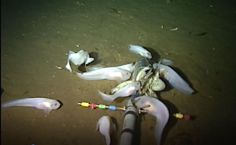
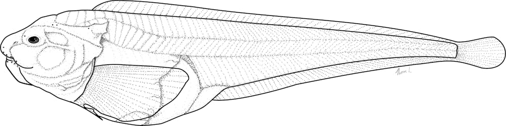
However, the world’s deepest-dwelling fish – known as a hadal snailfish – is small, pink and completely scaleless. Its skin is so transparent that you can see right through to its liver. Nonetheless, hadal snailfish are some of the most successful animals found in the ocean’s deepest places.
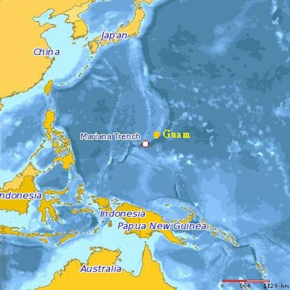
Our research team, which includes scientists from the United States, United Kingdom and New Zealand, found a new species of hadal snailfish in 2014 in the Mariana Trench. It has been seen living at depths of almost 27,000 feet (8,200 meters). We recently published its scientific description and officially christened it Pseudoliparis swirei. Studying its adaptations for living at such great depths has provided new insights about what kinds of life can survive in the deep ocean.
Exploring the hadal zone
We discovered this fish during a survey of the Mariana Trench in the western Pacific Ocean. Deep-sea trenches form at subduction zones, where one of the tectonic plates that form the Earth’s crust slides beneath another plate. They extend 20,000 to 36,000 feet deep below the ocean’s surface. The Mariana Trench is deeper than Mount Everest is tall.
Ocean waters in these trenches are known as the hadal zone. Our team set out to explore the Mariana Trench from top to bottom in an effort to understand what lives in the hadal zone; how organisms there interact; how they survive under enormous pressure created by six to seven miles of water above them; and what role hadal trenches play in the global ocean ecosystem.
Getting to the bottom
Sending instruments to the ocean floor is pretty straightforward. Bringing them back up is not. Researchers studying the deep sea often use nets, cameras or robots connected to ships by cables. But a 7-mile-long cable, even if it is very strong, can break under its own weight.
We used free-falling landers – mechanical platforms that carry instruments and steel weights and are not connected to the ship. When we deploy landers, it takes about four hours for them to sink to the bottom. To call them back, we use an acoustic signal that causes them to release their ballast and float to the surface. Then we search for them in the water (each carries an orange flag), retrieve them and collect their data.
Life in the trenches
Hadal trenches are named after Hades, the Greek god of the underworld. To humans, they are harsh, extreme environments. Pressure is as high as 15,000 pounds per square inch – equivalent to a large elephant standing on your thumb, and 1,100 times greater than atmospheric pressure at sea level. Water temperatures are as low as 33 degrees Fahrenheit (1 degree Celsius). Yet, a host of animals thrive under these conditions.
Our team put down cameras baited with mackerel to attract mobile animals in the trench. At shallower depths, from approximately 16,000 to 21,000 feet (5,000-6,500 meters) on the abyssal plain, we saw large fish such as rattails, cusk eels and eel pouts. At the upper edges of the trench, below 21,000 feet, we found decapod shrimp, supergiant amphipods (swimming crustaceans), and small pink snailfish. This newly discovered species of snailfish that lives to near 27,000 feet (8,200 meters), is now the world’s deepest living fish.
At the trench’s greatest depths, near 36,000 feet (11,000 meters), we saw only large swarms of small scavenging amphipods, which are somewhat similar to garden pill bugs. Amphipods live all over the ocean but are highly abundant in trenches. The Mariana snailfish that we filmed were eating these amphipods, which make up most of their diet.
The Mariana Trench houses the ocean’s deepest point, at Challenger Deep, named for the HMS Challenger expedition, which discovered the trench in 1875. Their deepest sounding, at nearly 27,000 feet (8,184 meters), was the greatest known ocean depth at that time. The site was named Swire Deep, after Herbert Swire, an officer on the voyage. We named the Mariana snailfish Pseudoliparis swirei in his honor, to acknowledge and thank crew members who have supported oceanographic research throughout history.
Life under pressure
Hadal snailfish have several adaptations to help them live under high pressure. Their bodies do not contain any air spaces, such as the swim bladders that bony fish use to ascend and descend in the water. Instead, hadal snailfish have a layer of gelatinous goo under their skins that aids buoyancy and also makes them more streamlined.
Hadal animals have also adapted to pressure on a molecular level. We’ve even found that some enzymes in the muscles of hadal fish are adapted to function better under high pressure.
Whitman College biologist Paul Yancey, a member of our team, has found that deep-sea fish use a molecule called trimethyl-amine oxide (TMAO) to help stabilize their proteins under pressure.
However, to survive at the highest water pressures in the ocean, fish would need so much TMAO in their systems that their cells would reach higher concentrations than seawater. At that high concentration, water would tend to flow into the cells due to a process called osmosis, in which water flows from areas of high concentration to low concentration to equalize. To keep these highly concentrated cells from rupturing, fish would have to continually pump water out of their cells to survive.
The evidence suggests that fish don’t actually live all the way to the deepest ocean depths because they are not able to keep enough TMAO in their cells to combat the high pressure at that depth. This means that around 27,000 feet (8,200 meters) may be a physiological depth limit for fish.
![]() There may be fish that live at levels as
deep, or even slightly deeper, than the Mariana snailfish. Different species of hadal snailfish are found in trenches worldwide, including
the Kermadec Trench off New Zealand, the Japan and Kurile-Kamchatka trenches in the northwestern Pacific, and the Peru-Chile
Trench. As a group, hadal snailfish seem to have found an unlikely haven in a place named for the proverbial hell.
There may be fish that live at levels as
deep, or even slightly deeper, than the Mariana snailfish. Different species of hadal snailfish are found in trenches worldwide, including
the Kermadec Trench off New Zealand, the Japan and Kurile-Kamchatka trenches in the northwestern Pacific, and the Peru-Chile
Trench. As a group, hadal snailfish seem to have found an unlikely haven in a place named for the proverbial hell.
Mackenzie Gerringer, Postdoctoral Researcher, University of Washington
This article was originally published on The Conversation. Read the original article.
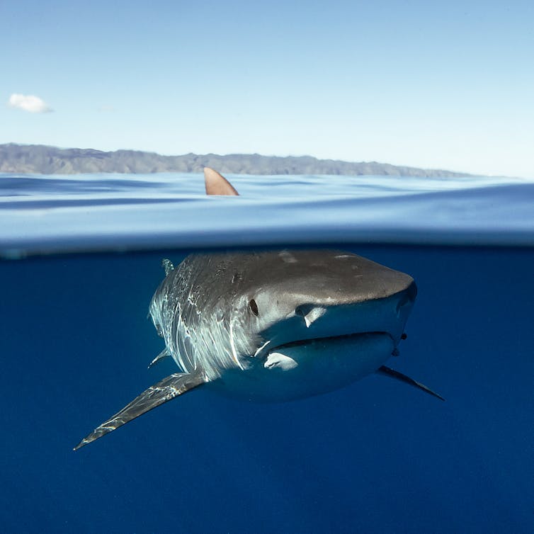
Why do shark bites seem to be more deadly in Australia than elsewhere?
The first thing to say about shark attack deaths is that they are very rare, with only about two per year in Australia. But still, every year without fail, people die from shark bites, both here and around the world.
According to official statistics, the United States records by far the most unprovoked shark bites – an average of 45 per year over the past decade. However, only 1.3% of these incidents were fatal – 0.6 deaths per year.
Australia records fewer bites than the US (an average of 14 per year), but a much greater proportion of them are deadly: (1.5 per year, or close to 11%). So what is it that (relatively speaking) makes Australia more prone to deadly shark attacks?
Read more: Not just nets: how to stop shark attacks without killing sharks
My new book Shark Attacks: Myths, Misunderstandings and Human Fear addresses this and other questions about sharks, with the aim of dispelling common myths and providing the knowledge needed for decisions made on science rather than fear and emotion.
A perfect storm
In a way, Australia has a “perfect storm” of conditions for serious shark attacks. The first reason is that Australians (and visitors to Australia) love the ocean. Some 85% of Australians live within 50km of the coast, and Australian coastal areas account for the most prominent growth outside of capital cities. Beaches are also favoured recreational destinations in Australia and coastal locations are heavily targeted in tourism, attracting nearly 60% of international tourists.
Next, the sharks themselves. Australia has the world’s highest diversity of sharks and rays, including roughly 180 of the 509 known shark species.
But neither of these factors, even taken together, is enough to explain why deaths are more prevalent in Australia. What we really need to look at is dangerous sharks.
Only 26 shark species have been definitively identified as biting humans without provocation, although the true number is likely to be somewhat higher. Of these 26 species, 22 (85%) are found in Australian waters.
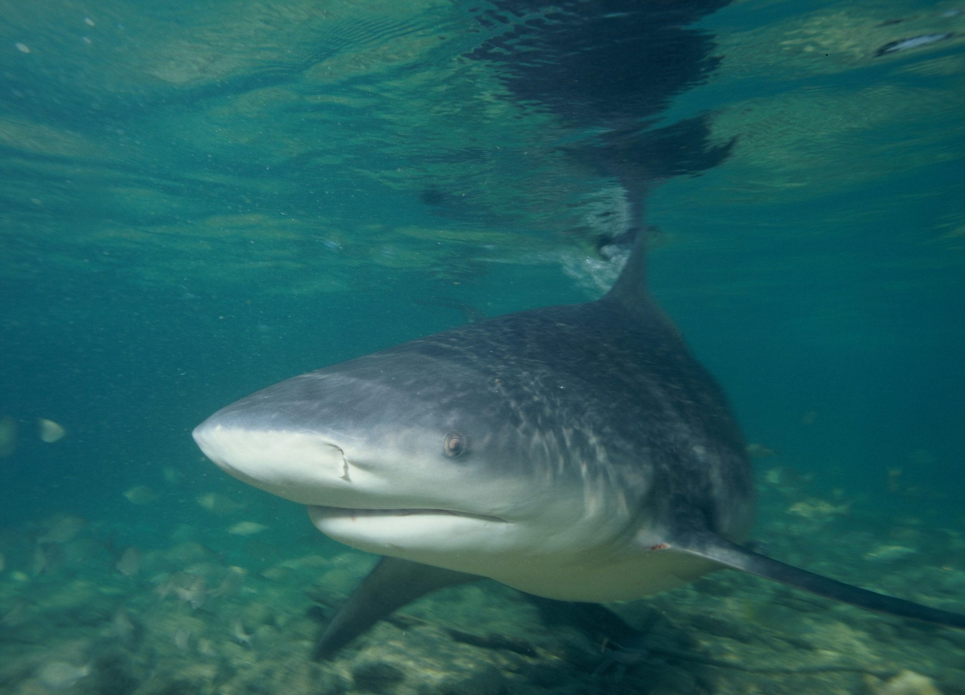
All 11 of the species known to have caused fatal unprovoked bites on humans can be found in Australian waters. And crucially, Australia’s coastal waters are home to all of the “big three” deadly species: white sharks, tiger sharks, and bull sharks.

These species account for all but three of the fatal shark attacks worldwide from 1982-2011. All of the big three species are inquisitive, regularly frequent coastal environments, and are formidably big and strong.
They also have complex, unpredictable behaviour. But despite this difficulty, we can identify factors that make them more likely to swim in areas routinely used by humans.
Warming to it
White sharks have a physiological adaptation that allows them to maintain a vast global distribution, and hence are responsible for the northernmost and southernmost recorded shark bites on humans.
Most fish are ectothermic, or cold-blooded, with body temperatures very close to that of the surrounding water. This restricts their range to places where the water temperature is optimal.
In contrast, white sharks and a few other related species can retain the heat generated by their muscles predominantly during swimming, enabling them to be swift and agile predators even in cold water. They do this with the help of bunches of parallel arteries and veins in their brains, eyes, muscles and stomachs that function as “heat exchangers” between incoming and outgoing blood, allowing them to keep these crucial organs warm.
White sharks are so good at retaining heat that their core body temperature can be up to 14.3℃ above the surrounding water temperature. This allows them to move seasonally up and down Australia’s east and west coasts, presumably following migrating prey species.
Getting salty
Bull sharks, meanwhile, are the only sharks known to withstand wide variations in water salinity. This means they can easily move from salty oceans to brackish estuaries and even travel thousands of kilometres up river systems. As a result they can overlap with human use areas such as canals, estuaries, rivers and even some lakes. One female bull shark was observed making a 4,000km round-trip to give birth in a secluded Madagascan estuary rather than the open ocean.
As a result, most bull sharks found in river systems are juveniles, but these areas may also be home to large, pregnant females who need to eat more prey to sustain themselves. As rivers are often clouded by sediment, there is an increased risk that a human may be mistaken for prey in this low-visibility environment.
Opportunistic tigers
Tiger sharks mainly stay in coastal waters, although they also venture into the open ocean. Their movements are unpredictable, they eat a wide range of prey, are naturally curious and opportunistic, and can be aggressive to humans.
Tiger sharks are clever too – they are thought to use “cognitive maps” to navigate between distant foraging areas, and have hunting ranges that span hundreds of thousands of square kilometres so as to maintain the element of surprise. As a result, tiger sharks’ distribution in Australian waters covers all but the country’s southern coast.

Read more: Finally, a proven way to keep great white sharks at arm’s length
Taken together, it’s clear that Australia’s waters are home to three predators that can pose a real danger, even if only an accidental one, to humans.
But remember that shark attacks are incredibly rare events, and fatal ones even rarer still. There are also lots of tips we can use to minimise the risk of having a negative encounter with a shark.
![]() Don’t swim in murky, turbid or dimly lit
water, as sharks may not be able to see you properly (and you may not be able to see them). Avoid swimming in canals, or far from the shore, or along dropoffs. Swim in designated areas and with
others, and avoid swimming where baitfish (or bait) may be present. And of course, always trust your instincts.
Don’t swim in murky, turbid or dimly lit
water, as sharks may not be able to see you properly (and you may not be able to see them). Avoid swimming in canals, or far from the shore, or along dropoffs. Swim in designated areas and with
others, and avoid swimming where baitfish (or bait) may be present. And of course, always trust your instincts.
Blake Chapman, Adjunct Research Fellow, Science Communicator, The University of Queensland
This article was originally published on The Conversation. Read the original article.
Understanding the feeding role of tiger sharks
Tiger sharks are one of the most successful large predators in the world’s oceans, but studying what they eat has been a challenge for researchers. Historically diet is studied through examining stomach contents, but scientists at the Australian Institute of Marine Science (AIMS) and collaborators are leading the way in understanding more about the feeding habits of sharks from their skin tissue. This allows us to learn about shark diet based on a quick non-lethal approach.
In a recent study, AIMS marine biologists Dr Luciana Ferreira, Dr Michelle Thums, Dr Mark Meekan and co-authors from a number of Australian universities, revealed their findings after examining the tissue samples of 273 tiger sharks from Western Australia to New South Wales and the Great Barrier Reef. Samples of blood and muscle tissue of tiger sharks showed information on the prey, position of individual sharks in the food chain, and even what type of habitat (coastal or offshore, seabed or open water) the animal had been feeding in.
Dr Ferreira said tiger sharks are large mobile animals and to ensure sustainable and resilient populations, we need better data on their feeding and behaviors. “In terms of predators, if we can understand the shark’s motivations and how they are using habitats, we can also understand their function within these habitats,” she said.

Difficulties involved in the direct observation of feeding behaviour of marine megafauna such as tiger sharks, has led to the use of alternative techniques to provide insights into the process of their foraging. One of the most common of these is the analysis of stable isotopes of carbon and nitrogen in their tissues, which can provide information on diet, feeding position in the food chain and interactions among different species, and their migratory movements. “Our analysis of stable isotopes shows that the functional role of tiger sharks in food-webs varied among different marine habitats we sampled along the tropical and temperate coasts of Australia,” Dr Ferreira said.
“Tiger sharks in Shark Bay and Ningaloo Reef in Western Australia, and on the Great Barrier Reef had long-term diets based in seagrass and reef-associated food webs. In these habitats they are focussed on turtles and dugong as prey. “In contrast, when sharks were sampled in more temperate habitats such the waters off New South Wales and southern Queensland, the composition of their tissues reflected a diet based on more pelagic [ocean-going] food webs, and they were focused on large fish. “Tiger sharks occupied roles at the top of food webs at Shark Bay in Western Australia and on the Great Barrier Reef, but not at Ningaloo Reef or off the coast of NSW. “This means the local environment and prey community appear to be the most important determinants of the diet of tiger sharks.” Dr Ferreira said the research confirmed the role of tiger sharks in Australian coastal ecosystems as opportunistic, flexible predators.
The research paper ‘The trophic role of a large marine predator, the tiger shark Galeocerdo cuvier’ is published in Nature Scientific Reports.
9 November 2017, Australian Institute of Marine Science, 2017
Marine Science News
Jaws at 50: how a single movie changed our perception of white sharks forever
Shark Defence Campaign. Sea Shephard have a new campaign
Marine Worm Offers Clues About Our Evolutionary Past
Offshore oil and gas infrastructure brings localised, but limited regional benefits for marine organisms
World-first initiative Guardian of the Great Barrier Reef
Marine Science facts
The vampire squid gets its name not because it has a taste for blood but from the dark skin on its arms that makes it look like it’s wearing a Dracula-esque cape?
The oceans provide 99% of the living space on the planet containing 50-80% of all life.
The Oceans cover 70% of the earths suface
The deepest part of the ocean is called the Mariana Trench, which is around 7 miles deep and is located in the South Pacific Ocean.
The water pressure at the bottom of the Mariana Trench is eight tons per square inch. This means the pressure there is enough to crush you.
The largest mountain range is found underwater and is called the Mid-Oceanic Ridge that is around 65,000 kilometres long.
Sponges are older than dinosaurs.
Half the Oxygen we breath is produced in the Ocean.
Irukandji jelly fish, with just a brush of venom leaves almost no mark. But after about a half hour you develop Irukandji syndrome, a debilitating mix of nausea, vomiting, severe pain, difficulty breathing, drenching sweating and sense of impending doom. You get so sick that your biggest worry is that you’re not going to die.
The most remote point in the oceans is called Point Nemo.
The Pacific, Atlantic, and Indian oceans are known as the three major oceans.