
Marine Science News 2019
Shark nets are destructive and don’t keep you safe – let’s invest in lifeguards
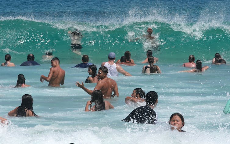
As Australians look forward to the summer beach season, the prospect of shark encounters may cross their minds. Shark control has been the subject of furious public debate in recent years and while some governments favour lethal methods, it is the wrong route.
Our study, published today in People and Nature, presents further evidence that lethal shark hazard management damages marine life and does not keep people safe.
We examined the world’s longest-running lethal shark management program, the New South Wales Shark Meshing (Bather Protection) Program, introduced in 1937. We argue it is time to move on from shark nets and invest further in lifeguard patrol and emergency response.
Managing shark bite
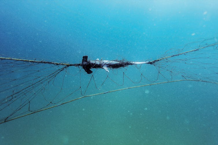
In NSW, 51 beaches between Newcastle and Wollongong are netted. The nets don’t provide an enclosure for swimmers. They are 150 metres long and suspended 500 metres offshore. In the process of catching targeted sharks they also catch other animals including turtles, rays, dolphins, and harmless sharks and fish.
Catching and killing sharks might seem a commonsense solution to the potential risk of shark bite to humans. But the story is not so simple.
Multiple factors influence shark bite incidence, including climate change, prey species distribution and abundance, water quality, human population, beach-use patterns, and lifeguard patrols.
Most research and public debate focuses on human safety or marine conservation. Our research sought to bring the two into conversation. We considered a range of factors that contribute to safety and conservation outcomes. This included catch of target and non-target species in nets, damage to marine ecosystems, global pressures on oceans, changing beach culture, human population growth and changes in lifeguarding and emergency response. Here’s what we found.
Fewer sharks, fewer bites
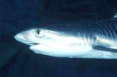
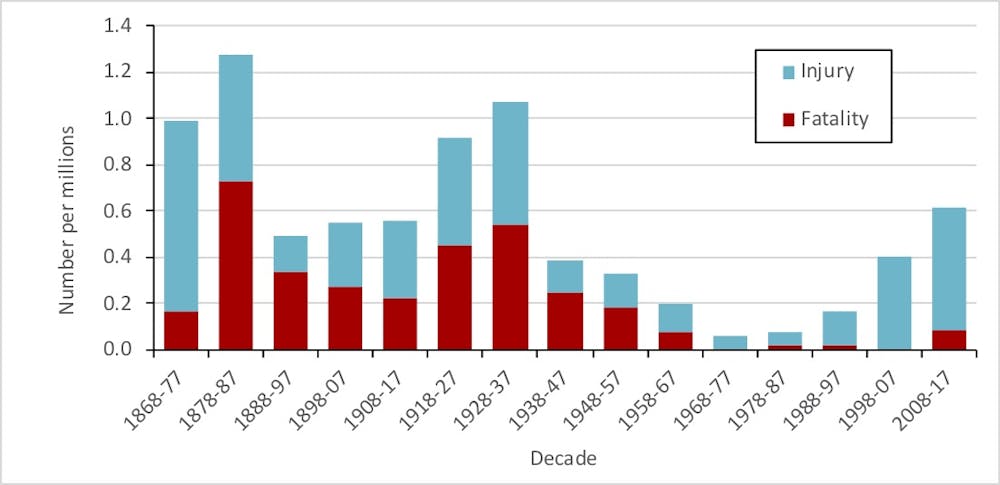
As the graph below shows, shark catch in the NSW netting program has fallen since the 1950s. This includes total shark numbers and numbers of three key target species: white shark (also known as great white or white pointer), tiger shark and bull shark.
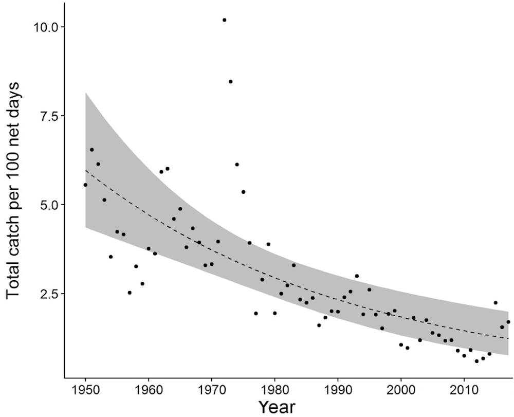
This suggests there are fewer sharks in the water, which is cause for alarm. The three target species are recognised by Australian and international institutions as threatened or near-threatened.
Our analysis shows shark bite incidence is also declining over the long term. The trend isn’t smooth; trends rarely are. The last two decades have seen more shark bites than the previous two. This is not surprising given Australia’s beach use has again grown rapidly in recent decades.
But if we take a longer term view, we see that shark bite incidence relative to population is substantially lower from the mid-20th century than during the decades before.
The decline in shark bite incidence is great news. But key points are frequently overlooked when society tries to make sense of the figures.
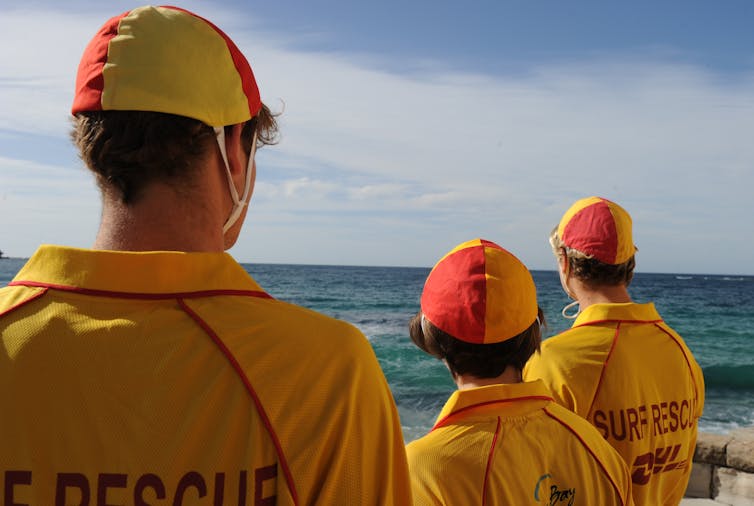
Lifeguard patrol and emergency response are key
In NSW, lifeguard beach patrol grew over the same time period as the shark meshing program. More people swam and surfed in the ocean from the early 20th century as public bathing became legal. The surf lifesaving and professional lifeguard movements grew rapidly in response.
Today, 50 of the 51 beaches netted through the shark meshing program are also patrolled by lifeguards or lifesavers. Yet improved safety is generally attributed to the mesh program. The role of beach patrol is largely overlooked.
So, claims that shark bite has declined at netted beaches might instead be interpreted as decline at patrolled beaches. In other words, reduced shark interactions may be the result of beach patrol.
More good news is that since the mid-20th century the proportion of shark bites leading to fatality has plummeted. This is most likely the result of enormous improvements in beach patrol, emergency and medical response.

It’s time to move on from shark nets
Debate over shark management is often polarised, pitting human safety against marine conservation. We have brought together expertise from the social sciences, biological sciences and fisheries, to move beyond a “people vs sharks” debate.
There is no reliable evidence that lethal shark management strategies are effective. Many people oppose them, institutions are moving away from them, and threatened species are put at risk.
The NSW Department of Primary Industries, manager of the shark meshing program, is investing strongly in new non-lethal strategies, including shark tagging, drone and helicopter patrol, personal deterrents, social and biophysical research and community engagement. Our study provides further evidence to support this move.
Investing in lifeguard patrol and emergency response makes good sense. The measures have none of the negative impacts of lethal strategies, and are likely responsible for the improved safety we
enjoy today at the beach.![]()
Leah Gibbs, Senior Lecturer in Geography, University of Wollongong; Lachlan Fetterplace, Environmental Assessment Specialist, Swedish University of Agricultural Sciences, and Quentin Hanich, Associate Professor, University of Wollongong
This article is republished from The Conversation under a Creative Commons license. Read the original article.
4 December 2019
250 Million Pieces of Trash at Remote Top End Australian Beach

A Sea Shepherd beach clean-up campaign in Northeast Arnhem Land has further exposed the catastrophic impact of marine plastic pollution on mainland Australia.
The Shocking Reality
Over seven tonnes of marine plastic pollution was removed by ten volunteers from Sea Shepherd Australia and Indigenous Rangers from the Dhimurru Aboriginal Corporation in a two-week-long collaboration at Djulpan Beach on the shores of the Gulf of Carpentaria, Northern Territory.
During the campaign, Sea Shepherd conducted scientific surveys across the 14-kilometre stretch of beach in collaboration with marine plastic pollution expert Dr Jennifer Lavers.
Findings from the surveys concluded that there were an estimated 250 million pieces of marine debris present.
Untrashing Djulpan: the Campaign
So remote and untouched by human contact is Djulpan Beach, Rangers cut a 4WD track from the nearest road to allow access for vehicles and equipment. The volume and density of plastic pollution removed from Djulpan was at a scale that the Sea Shepherd volunteers had not seen before on a mainland Australian beach, despite having facilitating over 600 clean-ups in the past three years.
Around 4.5 tonnes of the debris removed were consumer items including:
● plastic lids, tops and pump sprays (14494 pieces)
● plastic drink bottles (6054 pieces)
● cigarette lighters (3344 pieces
● personal care and pharmaceutical packaging (4881 pieces)
● thongs (3769 pieces)
● toothbrushes, hair brushes and hair ties (775 pieces) and
● toys such as chess pieces (64 pieces)
In many cases, the plastic items were so degraded that when volunteers went to pick them up, they crumbled into plastic dust.
The remaining 2.5 tonnes was made up of 72 different types of discarded fishing nets or ghost nets, some of which contained turtle bones.
Hundreds of plastic items were found with multiple animal bites, including those from fish and turtles. The stretch of coast that Djulpan is located on is home to six of the seven species of marine turtles which are all listed as ‘Vulnerable’ or ‘Endangered’ under the Environmental Protection and Biodiversity Conservation (EPBC) Act
Much of the trash found along Cape Arnhem originates from ocean currents and trade winds above Australia that pushes the debris into the Gulf of Carpentaria in a clockwise direction before washing ashore.

“The marine debris littering our beaches saddens us. Not only is it killing our turtles and other marine life, it also pollutes some of our sacred areas. The rangers work hard to try and keep the beaches clean, but we need to stop the rubbish going into the ocean in the first place.” -- Managing Director of the Dhimurru Aboriginal Corporation Mandaka Marika.
“What we found when we arrived at the beach on day one looked like something out of Armageddon, with plastic pieces visible across the entire beach as far as the eye could see. This campaign clearly shows that even in a remote place like Arnhem Land, that nowhere is safe from human-induced plastic pollution” -- Sea Shepherd Australia’s National Marine Debris Coordinator Liza Dicks.
What can you do?
Australia simply cannot turn a blind eye to the impacts that plastic pollution is having – whether it be on Australian shores or at the regional or global level. We need to come together and act now as a collective to ensure there is a solution to this increasing global environmental issue.
First published by SeaShephard: https://www.seashepherd.org.au/latest-news/untrashing-djulpan/
22 Sep 2019
Climate change may change the way ocean waves impact 50% of the world’s coastlines

The rise in sea levels is not the only way climate change will affect the coasts. Our research, published today in Nature Climate Change, found a warming planet will also alter ocean waves along more than 50% of the world’s coastlines.
If the climate warms by more than 2℃ beyond pre-industrial levels, southern Australia is likely to see longer, more southerly waves that could alter the stability of the coastline.
Scientists look at the way waves have shaped our coasts – forming beaches, spits, lagoons and sea caves – to work out how the coast looked in the past. This is our guide to understanding past sea levels.
But often this research assumes that while sea levels might change, wave conditions have stayed the same. This same assumption is used when considering how climate change will influence future coastlines – future sea-level rise is considered, but the effect of future change on waves, which shape the coastline, is overlooked.
Changing waves
Waves are generated by surface winds. Our changing climate will drive changes in wind patterns around the globe (and in turn alter rain patterns, for example by changing El Niño and La Niña patterns). Similarly, these changes in winds will alter global ocean wave conditions.
Further to these “weather-driven” changes in waves, sea level rise can change how waves travel from deep to shallow water, as can other changes in coastal depths, such as affected reef systems.
Recent research analysed 33 years of wind and wave records from satellite measurements, and found average wind speeds have risen by 1.5 metres per second, and wave heights are up by 30cm – an 8% and 5% increase, respectively, over this relatively short historical record.
These changes were most pronounced in the Southern Ocean, which is important as waves generated in the Southern Ocean travel into all ocean basins as long swells, as far north as the latitude of San Francisco.
Sea level rise is only half the story
Given these historical changes in ocean wave conditions, we were interested in how projected future changes in atmospheric circulation, in a warmer climate, would alter wave conditions around the world.
As part of the Coordinated Ocean Wave Climate Project, ten research organisations combined to look at a range of different global wave models in a variety of future climate scenarios, to determine how waves might change in the future.
While we identified some differences between different studies, we found if the 2℃ Paris agreement target is kept, changes in wave patterns are likely to stay inside natural climate variability.
However in a business-as-usual climate, where warming continues in line with current trends, the models agreed we’re likely to see significant changes in wave conditions along 50% of the world’s coasts. These changes varied by region.
Less than 5% of the global coastline is at risk of seeing increasing wave heights. These include the southern coasts of Australia, and segments of the Pacific coast of South and Central America.
On the other hand decreases in wave heights, forecast for about 15% of the world’s coasts, can also alter coastal systems.
But describing waves by height only is the equivalent of describing an orchestra simply by the volume at which it plays.
Some areas will see the height of waves remain the same, but their length or frequency change. This can result in more force exerted on the coast (or coastal infrastructure), perhaps seeing waves run further up a beach and increasing wave-driven flooding.
Similarly, waves travelling from a slightly altered direction (suggested to occur over 20% of global coasts) can change how much sand they shunt along the coast – important considerations for how the coast might respond. Infrastructure built on the coast, or offshore, is sensitive to these many characteristics of waves.
While each of these wave characteristics is important on its own, our research identified that about 40% of the world’s coastlines are likely to see changes in wave height, period and direction happening simultaneously.
While some readers may see intense waves offering some benefit to their next surf holiday, there are much greater implications for our coastal and offshore environments. Flooding from rising sea levels could cost US$14 trillion worldwide annually by 2100 if we miss the target of 2℃ warming.
How coastlines respond to future climate change will be a response to a complex interplay of many processes, many of which respond to variable and changing climate. To focus on sea level rise alone, and overlooking the role waves play in shaping our coasts, is a simplification which has great potential to be costly.
The authors would like to acknowledge the contribution of Xiaolan Wang, Senior Research Scientist at Environment and Climate Change, Canada, to this article.
![]()
Mark Hemer, Principal Research Scientist, Oceans and Atmosphere, CSIRO; Ian Young, Kernot Professor of Engineering, University of Melbourne; Joao Morim Nascimento, PhD Candidate, Griffith University, and Nobuhito Mori, Professor, Kyoto University
This article is republished from The Conversation under a Creative Commons license. Read the original article.
20 Aug 2019
No-take marine areas help fishers (and fish) far more than we thought
One hectare of ocean in which fishing is not allowed (a marine protected area) produces at least five times the amount of fish as an equivalent unprotected hectare, according to new research published today.
This outsized effect means marine protected areas, or MPAs, are more valuable than we previously thought for conservation and increasing fishing catches in nearby areas.
Previous research has found the number of offspring from a fish increases exponentially as they grow larger, a disparity that had not been taken into account in earlier modelling of fish populations. By revising this basic assumption, the true value of MPAs is clearer.
Marine Protected Areas
Marine protected areas are ocean areas where human activity is restricted and at their best are “no take” zones, where removing animals and plants is banned. Fish populations within these areas can grow with limited human interference and potentially “spill-over” to replenish fished populations outside.
Obviously MPAs are designed to protect ecological communities, but scientists have long hoped they can play another role: contributing to the replenishment and maintenance of species that are targeted by fisheries.
Wild fisheries globally are under intense pressure and the size fish catches have levelled off or declined despite an ever-increasing fishing effort.
Yet fishers remain sceptical that any spillover will offset the loss of fishing grounds, and the role of MPAs in fisheries remains contentious. A key issue is the number of offspring that fish inside MPAs produce. If their fecundity is similar to that of fish outside the MPA, then obviously there will be no benefit and only costs to fishers.
Big fish have far more babies
Traditional models assume that fish reproductive output is proportional to mass, that is, doubling the mass of a fish doubles its reproductive output. Thus, the size of fish within a population is assumed to be less important than the total biomass when calculating population growth.
But a paper recently published in Science demonstrated this assumption is incorrect for 95% of fish species: larger fish actually have disproportionately higher reproductive outputs. That means doubling a fish’s mass more than doubles its reproductive output.
When we feed this newly revised assumption into models of fish reproduction, predictions about the value of MPAs change dramatically.

Fish are, on average, 25% longer inside protected areas than outside. This doesn’t sound like much, but it translates into a big difference in reproductive output – an MPA fish produces almost 3 times more offspring on average. This, coupled with higher fish populations because of the no-take rule means MPAs produce between 5 and 200 times (depending on the species) more offspring per unit area than unprotected areas.
Put another way, one hectare of MPA is worth at least 5 hectares of unprotected area in terms of the number of offspring produced.
We have to remember though, just because MPAs produce disproportionately more offspring it doesn’t necessarily mean they enhance fisheries yields.
For protected areas to increase catch sizes, offspring need to move to fished areas. To calculate fisheries yields, we need to model – among other things – larval dispersal between protected and unprotected areas. This information is only available for a few species.
We explored the consequences of disproportionate reproduction for fisheries yields with and without MPAs for one iconic fish, the coral trout on the Great Barrier Reef. This is one of the few species for which we had data for most of the key parameters, including decent estimates of larval dispersal and how connected different populations are.
We found MPAs do in fact enhance yields to fisheries when disproportionate reproduction is included in relatively realistic models of fish populations. For the coral trout, we saw a roughly 12% increase in tonnes of caught fish.
There are two lessons here. First, a fivefold increase in the production of eggs inside MPAs results in only modest increases in yield. This is because limited dispersal and higher death rates in the protected areas dampen the benefits.
However the exciting second lesson is these results suggest MPAs are not in conflict with the interests of fishers, as is often argued.
While MPAs restrict access to an entire population of fish, fishers still benefit from from their disproportionate affect on fish numbers. MPAs are a rare win-win strategy.
It’s unclear whether our results will hold for all species. What’s more, these effects rely on strict no-take rules being well-enforced, otherwise the essential differences in the sizes of fish will never be established.
We think that the value of MPAs as a fisheries management tool has been systematically underestimated. Including disproportionate reproduction in our assessments of MPAs should correct this view
and partly resolve the debate about their value. Well-designed networks of MPAs could increase much-needed yields from wild-caught fish.
![]()
Dustin Marshall, Professor, Marine Evolutionary Ecology, Monash University and Liz Morris, Administration Manager, Monash University
This article is republished from The Conversation under a Creative Commons license. Read the original article.
July 4 2019
Next generation corals undergo first field tests on the Great Barrier Reef
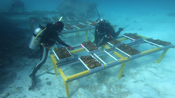
Hundreds of juvenile corals bred at the Australian Institute of Marine Science (AIMS) have survived being transplanted on the Great Barrier Reef, in a promising early test to help corals increase their resilience to marine heatwaves. The trial aims to show young coral offspring produced from mixing corals from warm northern reefs, with cooler central corals, can survive in cooler environments. This is the first test to assess the feasibility of the technique called Assisted Gene Flow at this larger scale on the Great Barrier Reef. The seven-month-old corals have one parent from the warmer northern reaches of the Reef and the other from the cooler central Reef.
AIMS marine scientist Dr Kate Quigley says research has shown the offspring inherit heat tolerance from their northern parents, and in time, they may pass on these heat tolerant genes and make reefs more resistant to future marine heat waves. “Last year we collected corals from the far north of the Great Barrier Reef that survived previous heat waves, and we flew them nearly 1000km to AIMS in Townsville,” Dr Quigley said.
“We have cross-fertilised them with corals from the middle of the Reef to see if the heat tolerance is passed on.”
Dr Line Bay, who leads AIMS’ research into reef recovery, adaptation and restoration, said Assisted Gene Flow, was helping nature to do what it does naturally, and is one of several techniques being developed at AIMS to help coral survive higher future ocean temperatures in coming decades. “When corals get too hot they are damaged and bleach, and this can lead to extensive mortality as we have recently seen on the Great Barrier Reef,” Dr Bay said. “If corals are to persist into the future, they have to cope with these increasing temperatures, and because of the rate of warming, they will have to become more tolerant fast. “We are focussed on developing new solutions for managing our coral reefs in a warming future.”

AIMS researchers took the same species of corals from three sites in the northern region, and two sites on the central Great Barrier Reef and cross-fertilised them in climate-controlled tanks at the National Sea Simulator in Townsville, to produce dozens of distinct genetic crosses. The National Sea Simulator is the world’s most advanced research aquarium. These crosses were then settled onto terracotta tiles and moved to a site on the Great Barrier Reef, in March.
This first expedition to check on these coral juveniles has just returned, and researchers are analysing the results. “We found many of the warm-adapted corals have survived the now quite cool waters of the central Reef,” Dr Quigley said. “This early result supports further testing of Assisted Gene Flow as a management action tool for corals in a warming future.” The field tests will add to results from experiments in the National Sea Simulator which showed these juvenile corals with at least one parent from the far northern Great Barrier Reef, are significantly more likely to survive high temperatures. AIMS researchers plan to return to the test site in October to check in again on how the corals are growing and surviving.
This research is partly funded by the partnership between the Australian Government’s Reef Trust and the Great Barrier Reef Foundation.
First published by AIMS July 2 2019
Deep sea carbon reservoirs once super-heated the Earth – could it happen again?
As concern grows over human-induced climate change, many scientists are looking back through Earth’s history to events that can shed light on changes occurring today. Analyzing how the planet’s climate system has changed in the past improves our understanding of how it may behave in the future.
It is now clear from these studies that abrupt warming events are built into Earth’s climate system. They have occurred when disturbances in carbon storage at Earth’s surface released greenhouse gases into the atmosphere. One of the grand challenges for climate scientists like me is to determine where these releases came from before humans were present, and what triggered them. Importantly, we want to know if such an event could happen again.
In a recently published study, my colleagues Katie Harazin, Nadine Krupinski and I discovered that at the end of the last glacial era, about 20,000 years ago, carbon dioxide was released into the ocean from geologic reservoirs located on the seafloor when the oceans began to warm.
This finding is a potential game-changer. Naturally occurring reservoirs of carbon in the modern ocean could be disturbed again, with potentially serious effects to Earth’s oceans and climate.
The past is prologue
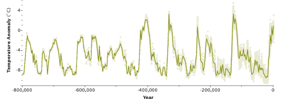
One of the best-known examples of a rapid warming caused by release of geologic carbon is the Paleocene-Eocene Thermal Maximum, or PETM, a major global warming event that occured about 55 million years ago. During the PETM, the Earth warmed by 9 to 16 degrees Fahrenheit (5 to 9 degrees Celsius) within about 10,000 years.
Climate scientists now consider the PETM to be an analog for environmental changes taking place today. The PETM happened over a longer period and without human involvement, but it shows that there is inherent instability in the climate system if carbon from geologic reservoirs is released rapidly.
Scientists also know that atmospheric carbon dioxide levels rose rapidly at the end of each of the late Pleistocene ice ages, helping to warm the climate. During the most recent warming episode, 17,000 years ago, the Earth warmed by 9 to 13 degrees Fahrenheit (5 to 7 degrees Celsius).
However, hundreds of scientific studies have failed to establish what caused the rapid carbon dioxide increases that ended each ice age. Researchers agree that the ocean must be involved because it acts as a large carbon capacitor, regulating the amount of carbon that resides in the atmosphere. But they are still searching for clues to understand what influences the amount of carbon in the ocean during abrupt climate changes.
Lakes on the ocean floor
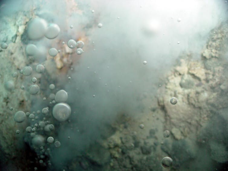
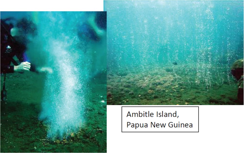
Over the past two decades, ocean scientists have discovered that there are reservoirs of liquid and solid carbon dioxide accumulating at the bottom of the ocean, within the rocks and sediments on the margins of active hydrothermal vents. At these sites, volcanic magma from within the Earth meets superheated water, producing plumes of carbon dioxide-rich fluids that filter through crevices in the Earth’s crust, migrating upward towards the surface.
When a plume of this fluid meets cold seawater, the carbon dioxide can solidify into a form called hydrate. The hydrate forms a cap that traps carbon dioxide within the rocks and sediments and keeps it from entering the ocean. But at temperatures above roughly 48 degrees Fahrenheit (9 degrees Celsius), hydrate will melt, releasing buoyant liquid or gaseous carbon dioxide directly into the overlying water.
Scientists have thus far documented reservoirs of liquid and hydrate carbon dioxide in the western Pacific near Taiwan and in the Aegean Sea. In shallower waters, where ocean temperatures are warmer and pressure is lower, researchers have observed pure carbon dioxide emanating directly from sediments as a gas and rising to the ocean’s surface.
A climate wild card
These discoveries are changing scientists’ understanding of the marine carbon system. Climate scientists have not included deep sea carbon reservoirs in current models that explore the potential impacts of future warming, because little is known about the size and distribution of these carbon sources.
In fact, there is virtually no data that documents how much carbon dioxide is currently being released from these reservoirs into the ocean. This makes the geologic history critically important: It confirms that these types of reservoirs have the capacity to release vast amounts of carbon when they are disturbed.
Analogous carbon reservoirs have also been identified in terrestrial environments. In 1979, Indonesia’s Dieng volcano suffocated 142 people when it released nearly pure carbon dioxide. In 1986, a carbon dioxide reservoir at the bottom of Lake Nyos in Cameroon erupted, killing 1,700 local villagers and hundreds of animals.
Carbon dioxide is also venting around Mammoth Mountain, California, at spots where magma rises through Earth’s crust and stalls at shallow depths. High concentrations of carbon dioxide in the soil have killed more than 100 acres of trees. Scientists are working to identify and characterize other sites on land where such releases could occur.
It is much more challenging to quantify the carbon dioxide stored in ocean reservoirs. Vast regions of the seafloor contain sites of active volcanism and hydrothermal venting, but scientists know virtually nothing about how much carbon dioxide is accumulating in surrounding rocks and sediments. In my view, there is an urgent need to study marine settings where carbon dioxide is likely accumulating, and then to assess how susceptible they may be to destabilization.
Warming oceans, increasing risk
This is not an endeavor that should be deferred. Earth’s oceans are warming rapidly, and climate models project that they will warm fastest near the poles, where deep currents form that carry warming waters downward from the surface.
As these warm waters sink into the ocean’s interior, they transport excess heat towards sites where carbon dioxide reservoirs can form. Those warmer waters will eventually destabilize the hydrate seals that keep liquid carbon dioxide trapped.
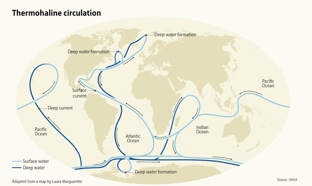
One such reservoir occurs in the western Pacific west of the Okinawa Trough in the East China Sea. The temperature of the bottom waters at this location is 37 to 39 degrees Fahrenheit (3 to 4 degrees Celsius), which means the hydrate cap is within about 4-5 degrees Celsius of its melting point.
Importantly, warm hydrothermal fluids are rising from below the carbon dioxide reservoir toward the surface. As the oceans continue to warm, the temperature difference between cold ocean waters and warmer hydrothermal fluids will decrease. This will cause the hydrate to thin, potentially to a point where it will no longer keep liquid carbon dioxide from escaping.
To date there has been no research to assess whether these ocean carbon dioxide reservoirs are vulnerable to rising ocean temperatures. But Earth’s pre-historic record clearly demonstrates that
geologic reservoirs can be destabilized – and that when they are, it leads to rapid increases in atmospheric carbon dioxide and global warming. In my view, this represents an important unknown
risk that cannot be ignored.![]()
Lowell D. Stott, Professor, University of Southern California – Dornsife College of Letters, Arts and Sciences
This article is republished from The Conversation under a Creative Commons license. Read the original article.
9 May 2016
Floating cities: the future or a washed-up idea?
Humans have a long history of living on water. Our water homes span the fishing villages in Southeast Asia, Peru and Bolivia to modern floating homes in Vancouver and Amsterdam. As our cities grapple with overcrowding and undesirable living situations, the ocean remains a potential frontier for sophisticated water-based communities.
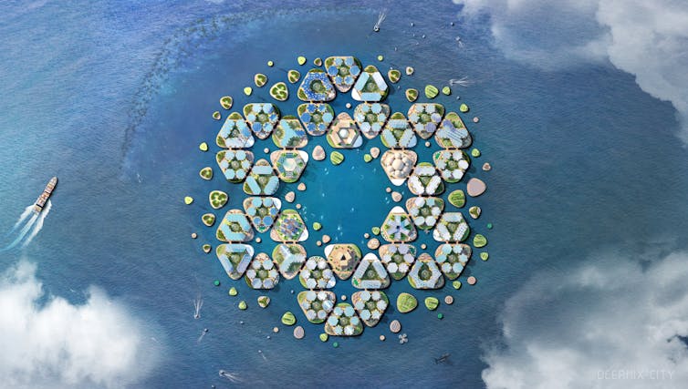
The United Nations has expressed support for further research into floating cities in response to rising sea levels and to house climate refugees. A speculative proposal, Oceanix City, was unveiled in April at the first Round Table on Sustainable Floating Cities at UN headquarters in New York.
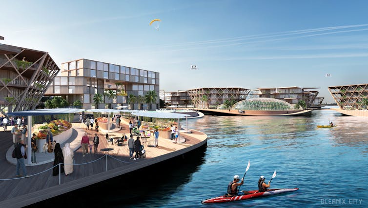
The former tourism minister of French Polynesia, Marc Collins Chen, and architecture studio BIG advanced the proposal. Chen is involved with the Seasteading Institute, which is seeking to develop autonomous city-states floating in the shallow waters of “host nations”.
While this latest proposal has gained UN attention, it is an old idea we have repeatedly returned to over the past 70 years with little success. In fact, the Oceanix City proposal has not reached the same level of technical sophistication as previous models.
A brief history of floating cities
The architecture community was fascinated with marine utopias between the 1950s and ’70s. The technological optimism of this period led architects to consider whether we could build settlements in inhospitable places like the polar regions, the deserts and on the sea.
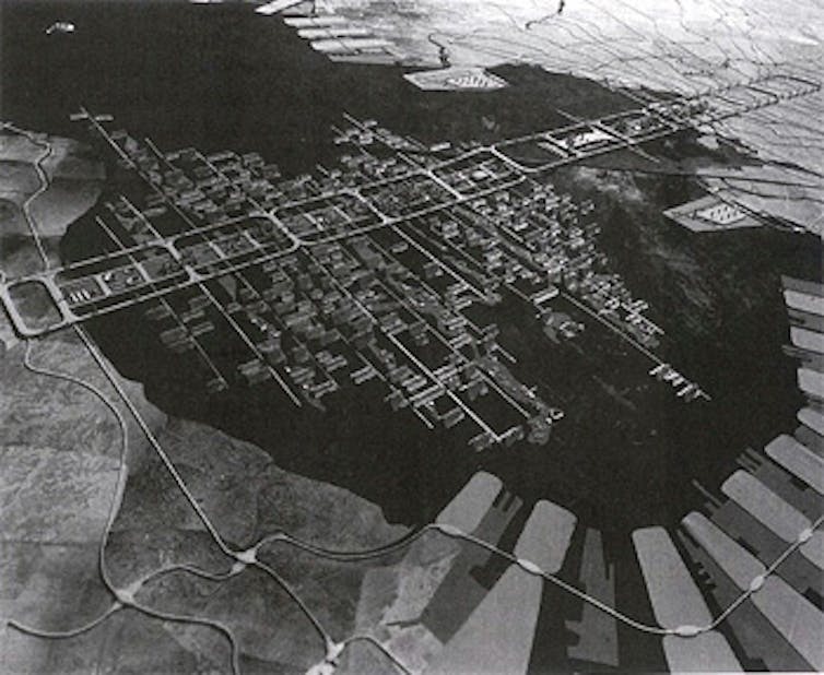
#/media/File:Tokyo_Bay_Plan_by_Tange_1960.jpg)
The Japanese Metabolists put forward incredible projects such as Kenzo Tange’s 1960 Tokyo Bay Plan and the marine city proposals of Kikutake and Kurokawa.
In the West, Buckminster Fuller proposed Triton City, which would be connected to the mainland via bridges. Archigram, a neofuturistic architectural group, proposed underwater sea farms.
These proposals were directed at solving the impending urban crises of overpopulation and pressures on land-based resources. Many were even sophisticated enough to be patented.
The arc of this global architectural discussion was captured during the first UN Habitat conference (“Habitat I”) in Vancouver in 1976. In many ways, the UN has returned to the Vancouver Declaration from Habitat I to “[adopt] bold, meaningful and effective human settlement policies and spatial planning strategies” and to treat “human settlements as an instrument and object of development”.
We are seeing a pivoting that began in 2008 with Vincent Callebaut’s “Lilypad” - a “floating ecopolis for ecological refugees”.
Where floating cities were once dismissed as too far-fetched, the concept has been repackaged and is re-emerging into public consciousness. This time in a more politically viable state - as a means of addressing the climate emergency.
The technology and types of floating city structures
No floating settlements have ever been created on the high seas. Current offshore engineering is concerned with how cities can locate infrastructure, such as airports, nuclear power stations, bridges, oil storage facilities and stadiums, in shallow coastal environments rather than in deep international waters.
Two main types of very large floating structures (VLFS) technology can be used to carry the weight of a floating settlement.
The first, pontoon structures, are flat slabs suitable for floating in sheltered waters close to shore.
The second, semi-submersible structures (such as oil rigs), comprise platforms that are elevated on columns off the water surface. These can be located in deep waters. Potentially, oil rigs could be repurposed for such floating cities in international waters.
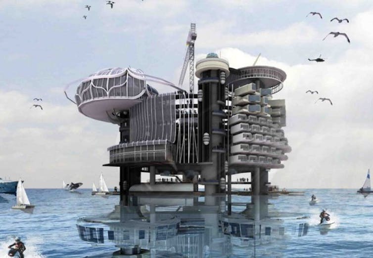
Oceanix City is based on the pontoon structure. This would restrict it to shallower waters with breakwaters to limit the impacts of waves. This sort of structure could serve as an extension of a coastal city, as a life raft for island communities inundated by rising waters, or to provide mobile essential services to residents of flood-prone slums.
Sovereign floating cities and micronations
While some early marine utopian proposals were responses to emerging urban issues, many proposals conceptualised “seaborne leisure colonies”. These communities would be independent city-states allowing inhabitants to circumvent tax laws or restrictions on medical research in their own countries.
This sort of floating city was conceived of as a micronation with sovereignty and ability to provide citizenship to its occupants. The example was set by the Principality of Sealand, off the coast of Britain.
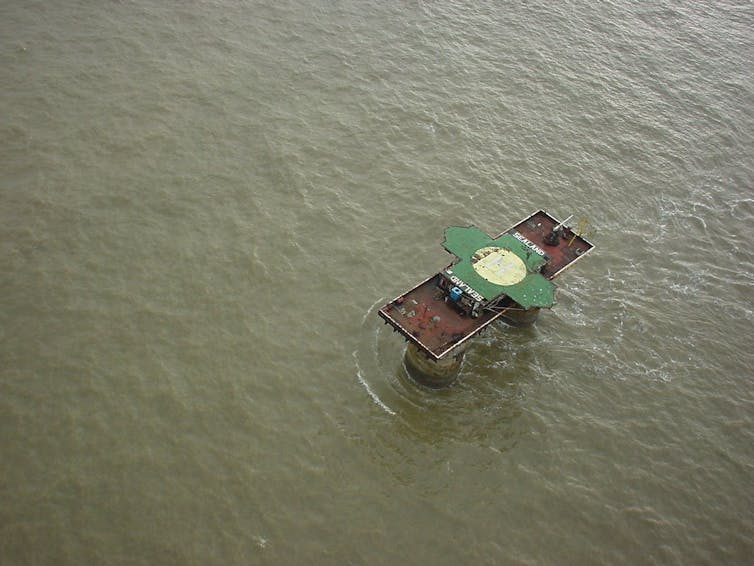
None of these proposals have succeeded. Even modern attempts such as the Freedom Ship and the Seasteading Institute’s plans for an autonomous floating settlement under French Polynesian jurisdiction have stalled. A recent attempt at creating a sovereign micronation (seastead) off Thailand led to its proponents becoming fugitives, potentially facing the death penalty.
A viable project?
Technology is not a barrier to floating cities in international waters. Advances in technology enable us to create structures for habitation in deep sea waters. These schemes have never really taken off because of political and commercial barriers.
While this time round proponents are packaging floating cities in a more politically viable concept as a life raft for climate refugees, commercial barriers remain. Apart from the UN, few organisation have the economic and political influence or reason to deliver a satellite floating city in the ocean.
In my view, the future of ocean cities is in technology campuses and in tourism. Given the significant risk of a community in extreme isolation in international waters, the solution to bringing people together in mid-ocean requires us to think about what connects us: technology, work and play. In these three elements we see, perhaps, the two lowest-hanging fruits (or the most buoyant of possibilities) for ocean cities.
The first is in floating tech campuses where large technology companies set up floating data centres and campuses in international waters. Situated outside national jurisdictions, these campuses could circumvent increasingly onerous privacy regimes or offer innovative technological services without having to negotiate regulatory barriers.
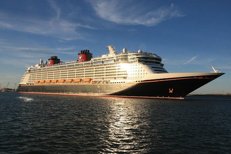
The second prospect is a return to the seaborne leisure colonies of the past. Companies like Disney could expand on their cruise offerings to build floating theme parks. These resorts could be sited in international waters or hosted by coastal cities.
Given our fascination with living on water, even if Oceanix City does not suceed, it won’t be long before we see another floating city proposal. And if we get the mix of social, political and
commercial drivers right, we might just find ourselves living on one.![]()
Brydon T. Wang, Research Assistant and PhD Candidate, Queensland University of Technology
This article is republished from The Conversation under a Creative Commons license. Read the original article.
3 June 2019
New threat revealed for baby turtles: jetties shelter hatch-ling hungry predators

New research has revealed that marine turtle hatchlings entering the ocean close to jetties have a high likelihood of being eaten. The study, published today in Biological Conservation, found structures such as jetties are an attractive shelter for hungry fish as they lie in wait for an easy evening meal. Lead author Phillipa Wilson, a PhD candidate at The University of Western Australia (jointly supervised through the Australian Institute of Marine Science), said the study provides evidence that jetties near turtle nesting beaches increase the predation of turtle hatchlings.
“Jetties attract large numbers of predatory fish, such as mangrove jack. They provide an artificial shelter for the fish, and when located near turtle nesting beaches can greatly increase the threat to hatchlings,” she said.
“Nearly three quarters of the hatchlings entering the sea for the first time were taken by fish while still close to shore. This means that baby turtles were seven times more likely to be preyed upon than at a beach nearby with no jetty”.

Dr Scott Whiting, from the Western Australian Department of Biodiversity, Conservation and Attractions’ marine science program said this research provides evidence to assist decision making around coastal developments near turtle-nesting beaches such as jetty installation or decommissioning of infrastructure.
“As coastal development is one of the primary threats to marine turtles around the world, understanding the effects of jetties will be extremely useful to managers when advising on environmental impacts associated with these structures,” he said.
The team of scientists from UWA, AIMS, DBCA and Pendoley Environmental tracked flatback turtle hatchlings on Thevenard Island off Australia’s north west coast. This marine turtle species nests only on Australian beaches and is classified as ‘vulnerable’ by the EPBC Act.
Small, sound-emitting tags were attached to 61 recently hatched flatback turtles to monitor their movements in the ocean. Signals from the tags were detected by a grid of underwater receivers, allowing scientists to track them as they swam out to sea.

Dr Michele Thums, co-author from the Australian Institute of Marine Science, pioneered the use of the tiny tags to remotely track turtle hatchlings in water, which allowed for predation rates of hatchlings to be measured remotely for the first time.
“Only a very small proportion of turtle hatchlings survive to maturity – this may be as low as one in one thousand. As the hatchlings represent the next generation, any increase in mortality, as we document here, can effect turtle population numbers in the future,” she said.

Ms Wilson said it was normal for turtle hatchlings to swim quickly in a straight line away from the beach, out to the relative safety of the open ocean.
“However, the baby turtles we tracked behaved differently by swimming parallel to the beach and many of them resided under the jetty during the day. This is when we realised we were no longer tracking swimming hatchlings, but tagged hatchlings inside the stomach of the fish that ate them,” she said.
The predatory fish used the jetty as shelter during the day, and at night they left the jetty to feed on hatchlings along the nearshore zone.
The paper ‘High predation of marine turtle hatchlings near a coastal jetty’ was published today in Biological Conservation.
The project was a collaboration between the Australian Institute of Marine Science and The University of Western Australia with the Department of Biodiversity, Conservation and Attractions and Pendoley Environmental. Project funding was provided predominantly from DBCA through the Northwest Shelf Flatback Turtle Conservation Program.
first published by AIMS: https://www.aims.gov.au/docs/media/latest-releases
22 May 2019
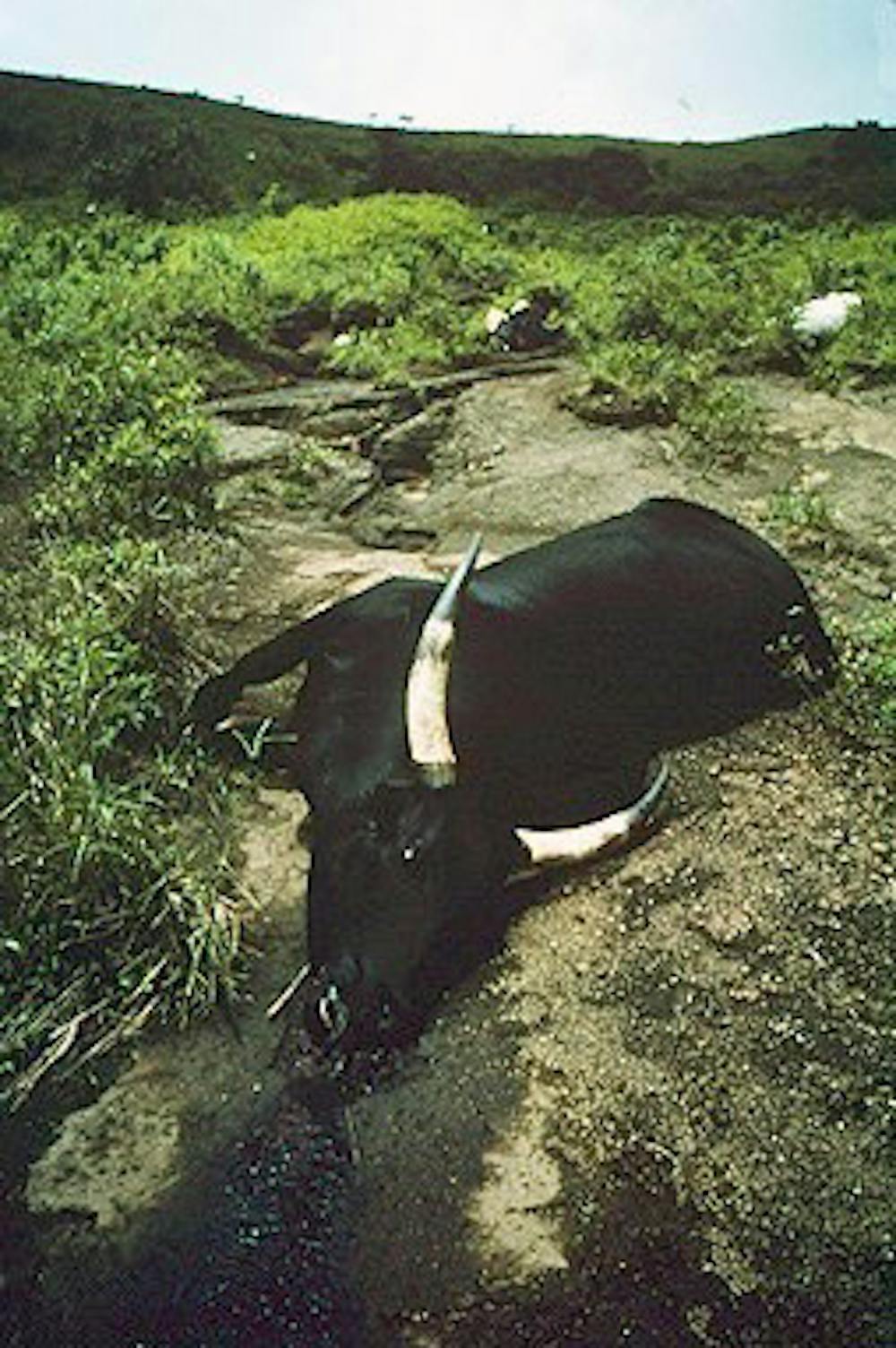
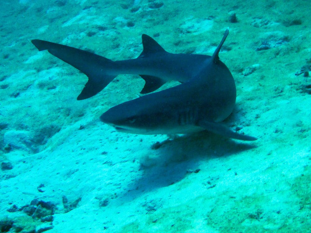
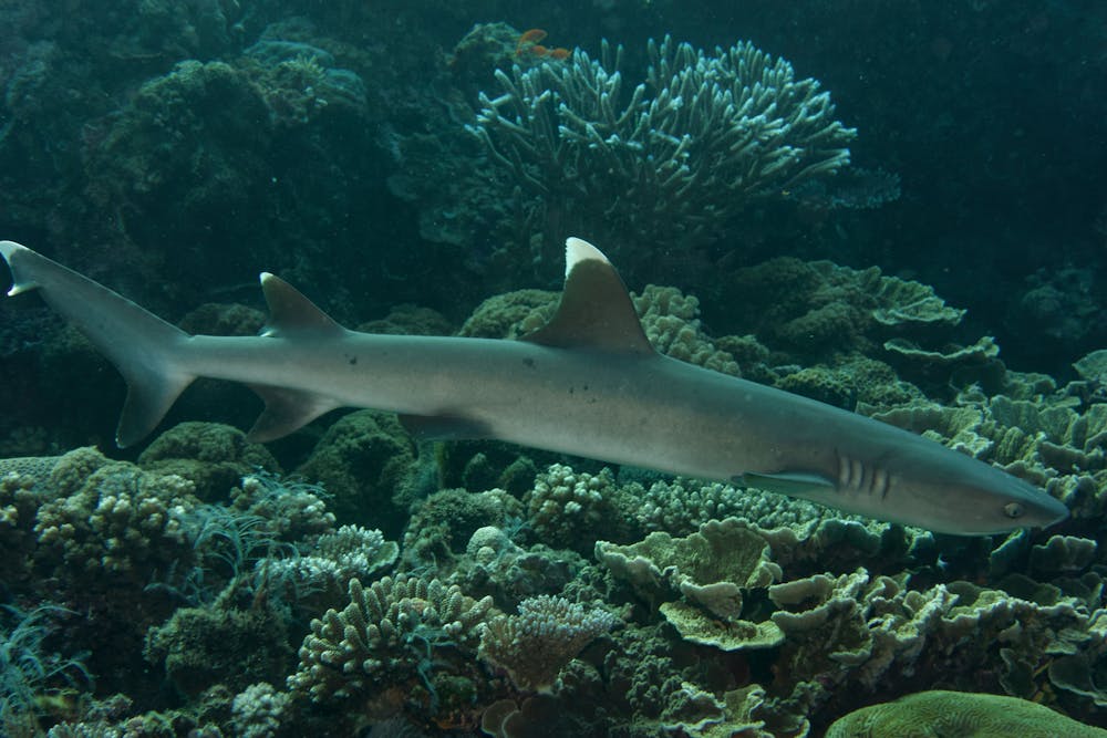
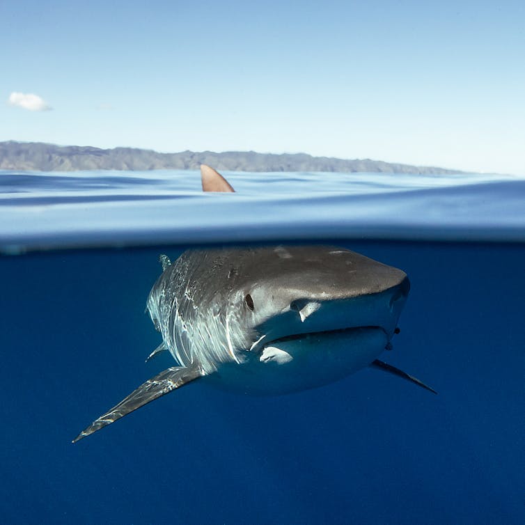
Tiger sharks revealed as lazy predators
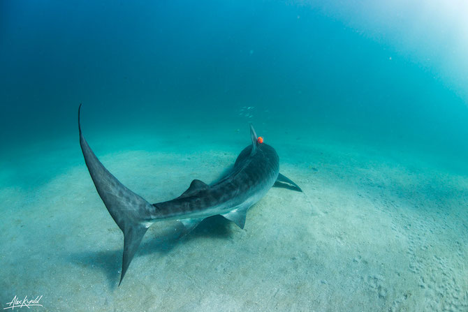
One of the ocean’s top predators – the tiger shark - has been revealed as a relaxed and sometimes lazy hunter by scientists studying their behaviour. Researchers from the Australian Institute of Marine Science (AIMS) and Murdoch University’s Harry Butler Institute attached specialist tags which combined cameras with motion and environmental sensors, to 27 tiger sharks in the Ningaloo Reef off the coast of Western Australia.
Collecting 60 hours of footage, the tags revealed the 3D movements of the sharks in relation to their prey, showing a number of target species including turtles, large fish and other sharks performing escape manoeuvres when a tiger shark showed interest.
AIMS PhD graduate Dr Samantha Andrzejaczek said tiger sharks were surprisingly lazy predators.
“Our tagged sharks just continued on their courses without attempting to predate on the alert individual even if they were right in front of them,” said Dr Andrzejaczek, a lead author on a research paper released today.
“We found the sharks were more likely to use stealth to sneak up on their prey.”
AIMS senior researcher and shark expert Dr Mark Meekan said the cameras they attached to the sharks gave them an unprecedented view of the role of tiger sharks in coral reef environments. “We can begin to understand not just what the animals are eating, but how they alter the behaviours of the prey around them and how this may impact the coral reef,” Dr Meekan said. “As we come up with strategies to manage and conserve these systems into the future, we need to understand how they are controlled from the top down, meaning we need to understand how these top predators are using these reefs.”
Dr Adrian Gleiss of Murdoch University’s Harry Butler Institute compared tiger sharks to lions.
“They don’t waste energy stalking prey that are already aware of them and can easily escape,” Dr Gleiss said. “These sharks minimise energy output and chances of success by sneaking up on unsuspecting turtles and large fish.”

The tags revealed the tiger sharks frequently hunted in the shallow sandflat habitats of Ningaloo Reef.
Clamped to the dorsal fins of the sharks by hand, the tags automatically detached after 24 to 48 hours. The floating tags were tracked down using a radio antenna, and the data downloaded, providing the researchers with a day or more in the life of the shark.
The project was conducted by scientists from the Australian Institute of Marine Science, Murdoch University, the University of Western Australia and Stanford University in California.
The research paper “Biologging Tags Reveal Links Between Fine-Scale Horizontal and Vertical Movement Behaviors in Tiger Sharks” was published in Frontiers in Marine Science.
First published by AIMS (https://www.aims.gov.au/docs/media/latest-news)
1 May 2019
Most recreational fishers in Australia support marine sanctuaries

More than 70% of recreational fishers support no-take marine sanctuaries according to our research, published recently in Marine Policy.
This study contradicts the popular perception that fishers are against establishing no-take marine reserves to protect marine life. In fact, the vast majority of fishers we surveyed agreed that no-take sanctuaries improve marine environmental values, and do not impair their fishing.
Read more: More than 1,200 scientists urge rethink on Australia's marine park plans
No-take marine sanctuaries, which ban taking or disturbing any marine life, are widely recognised as vital for conservation. However, recent media coverage and policy decisions in Australia suggest recreational fishers are opposed to no-take sanctuary zones created within marine parks.
This perceived opposition has been reinforced by recreational fishing interest groups who aim to represent fishers’ opinions in policy decisions. However, it was unclear whether the opinions expressed by these groups matches those of fishers on-the-ground in established marine parks.
To answer this, we visited ten state-managed marine parks across Western Australia, South Australia, Queensland and New South Wales. We spoke to 778 fishers at boat ramps that were launching or retrieving their boats to investigate their attitudes towards no-take sanctuary zones.
Our findings debunk the myth that recreational fishers oppose marine sanctuaries. We found 72% of active recreational fishers in established marine parks (more than 10 years old) support their no-take marine sanctuaries. Only 9% were opposed, and the remainder were neutral.
We also found that support rapidly increases (and opposition rapidly decreases) after no-take marine sanctuaries are established, suggesting that once fishers have a chance to experience sanctuaries, they come to support them.
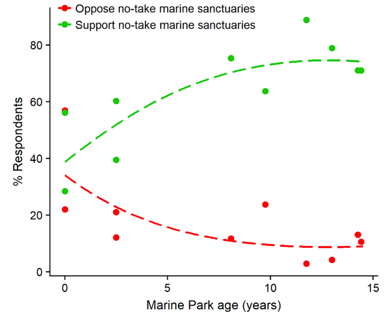
Fishers in established marine parks were also overwhelmingly positive towards marine sanctuaries. Most thought no-take marine sanctuaries benefited the marine environment (78%) and have no negative impacts on their fishing (73%).
We argue that recreational fishers, much like other Australians, support no-take marine sanctuaries because of the perceived environmental benefits they provide. This is perhaps not surprising, considering that appreciating nature is one of the primary reasons many people go fishing in the first place.
In the past opposition from recreational fishing groups has been cited in the decision to scrap proposed no-take sanctuaries around Sydney, to open up established no-take sanctuaries to fishing and to reduce sanctuaries within the Australia Marine Parks (formerly the Commonwealth Marine Reserve network).
Our findings suggest that these policy decisions do not reflect the beliefs of the wider recreational fishing community, but instead represent the loud voices of a minority.
We suggest that recreational fishing groups and policy makers should survey grass roots recreational fishing communities (and other people who use marine parks) to gauge the true level of support for no-take marine sanctuaries, before any decisions are made.
Read more: The backflip over Sydney's marine park is a defiance of science
Despite what headlines may say, no-take marine sanctuaries are unlikely to face long lasting opposition from recreational fishers. Instead, our research suggests no-take marine sanctuaries
provide a win-win: protecting marine life whilst fostering long term support within the recreational fishing community.
![]()
Matt Navarro, Post-doctoral Fellow, University of Western Australia; Marit E. Kragt, Senior Lecture in Agricultural and Resource Economics, and Tim Langlois, Research Fellow, University of Western Australia
This article is republished from The Conversation under a Creative Commons license. Read the original article.
Feb 18 2019
The presence of people is slowing shark recovery on the Great Barrier Reef
Much of the Great Barrier Reef is legally protected in an effort to conserve and rebuild the fragile marine environment. Marine reserves are considered the gold standard for conservation, and often shape our perception of what an “undisturbed ecosystem” should look like.
However our research, published today in Frontiers in Ecology and the Environment, suggests that “no-take” marine reserves may be failing shark populations on the Great Barrier Reef.
After 40 years of protection, the average amount of reef sharks in no-take reserves (areas where fishing is forbidden but people can boat or swim) was only one-third that in strictly enforced human exclusion areas. The difference, we argue, is down to poaching, raising serious questions about the effectiveness of no-take reserves.
Read more: More than 1,200 scientists urge rethink on Australia's marine park plans
Sharks on coral reefs
Three species of shark are dominant on Indo-Pacific coral reefs: grey reef sharks, blacktip reef sharks, and whitetip reef sharks. All three of these species are considered high-level predators, but the combination of slow reproductive rates and high fishing pressure has depleted reef shark populations across much of their range.
Well-designed and enforced no-take marine reserves help rebuild reef shark populations, but it is not known whether these reserves can facilitate full recovery to baseline (unexploited) levels, or how long the recovery process might take.
No-take marine reserves
No-take marine reserves are firmly advocated as an effective way to combat overfishing. With few exceptions, well-enforced no-take marine reserves result in rapid increases in target fish populations, leading to flow-on benefits such as better fisheries in outlying areas.
In many cases, no-take marine reserves are considered to have intact ecology and therefore drive our perceptions of what undisturbed ecosystems should look like.
The entire Great Barrier Reef was open to fishing until 1980, when no-take reserves were established. More reserves were created over the next two and a half decades, resulting in reserves that vary in age from 14-39 years. A small number of no-entry reserves, which are completely off limits to humans, were also implemented during this period to guard against the potential effects of activities such as boating and diving.
Given that fishing is prohibited in both no-take and no-entry reserves, we expected shark populations to be similar in both areas. Due to the exclusion of humans from no-entry reserves, shark populations within these areas are largely unknown and have only been assessed once, 10 years after protection.
Read more: Killing sharks is killing coral reefs too
This past research revealed that shark populations were much greater inside no-entry reserves compared to no-take reserves, but this does not allow us to determine whether recovery is ongoing or complete. The diverse ages of marine reserves within the GBR provide a unique opportunity to investigate the potential recovery of reef shark populations and evaluate the performance of no-entry and no-take reserves as tools for shark conservation.
What we found
Using underwater survey data from 11 no-take reserves and 13 no-entry reserves, we reconstructed reef shark populations through the past four decades of protection. Surprisingly, we found shark populations were substantially higher – with two-thirds more biomass – in no-entry reserves than in no-take reserves, indicating that the latter do not support near-natural shark populations.
We looked at potential drivers of shark abundance and found that coral cover, habitat complexity, reef size, distance to shore, and the distance to the nearest fished reef could not explain the large differences between no-take and no-entry reserves.
We argue the disparity between no-entry and no-take reserves is likely due to poaching in no-take reserves. Recent research found up to 18% of recreational fishers admit to fishing illegally.
Enforcement of no-entry reserves is much easier than no-take reserves as evidence of fishing is not required for prosecution. On the other hand, vessels are allowed to be present in no-take reserves, leaving these areas susceptible to poaching. Given the slow reproductive rate of reef sharks, even small amounts of fishing may reduce their populations.
The Great Barrier Reef is one of the most intensely managed marine parks in the world. Despite this, our results reveal that no-take reserves fall well short of restoring shark populations to near-natural levels, and that up to 40 years of strong protection is required to rebuild shark populations.
These results also highlight that no-take marine reserves inadequately reflect ecological baselines and that we may need to reevaluate what we consider to be a natural, intact reef ecosystem.
Read more: The majority of people who see poaching in marine parks say nothing
While the creation of more and larger no-entry reserves may solve the problem, this approach is likely to be unpopular and politically undesirable. An alternative approach, would be to tackle
poaching by enlisting fishing communities in the fight against illegal fishing, better education, and increasing enforcement.
![]()
Justin Rizzari, Lecturer in Fisheries Science, Deakin University and Ashley J Frisch, Research Coordinator at Reef HQ / GBRMPA, James Cook University
This article is republished from The Conversation under a Creative Commons license. Read the original article.
February 1 2019
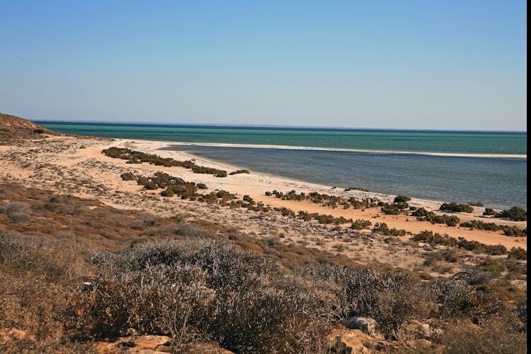
Shark Bay: A World Heritage Site at catastrophic risk
The devastating bleaching on the Great Barrier Reef in 2016 and 2017 rightly captured the world’s attention. But what’s less widely known is that another World Heritage-listed marine ecosystem in Australia, Shark Bay, was also recently devastated by extreme temperatures, when a brutal marine heatwave struck off Western Australia in 2011.
A 2018 workshop convened by the Shark Bay World Heritage Advisory Committee classified Shark Bay as being in the highest category of vulnerability to future climate change. And yet relatively little media attention and research funding has been paid to this World Heritage Site that is on the precipice.
Read more: Shark Bay stromatolites at risk from climate change
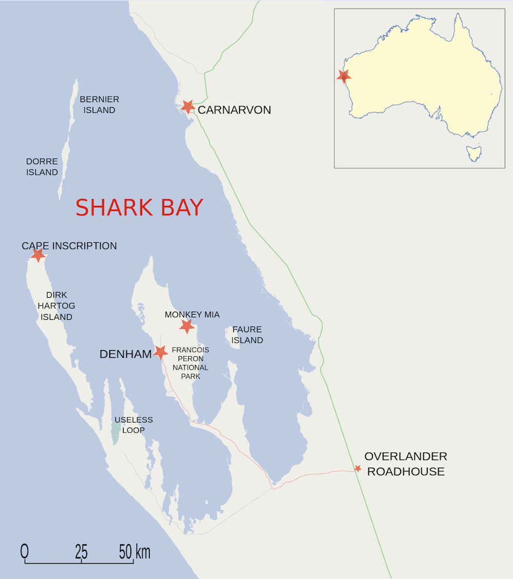
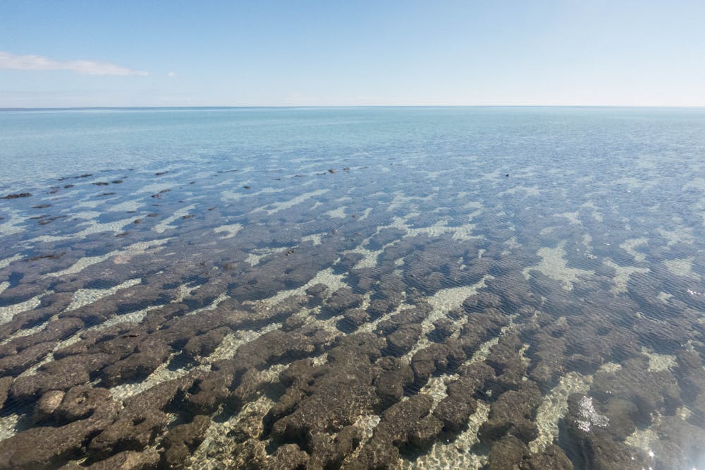
Shark Bay, in WA’s Gascoyne region, is one of 49 marine World Heritage Sites globally, but one of only four of these sites that meets all four natural criteria for World Heritage listing. The marine ecosystem supports the local economy through tourism and fisheries benefits.
Around 100,000 tourists visit Shark Bay each year to interact with turtles, dugongs and dolphins, or to visit the world’s most extensive population of stromatolites – stump-shaped colonies of microbes that date back billions of years, almost to the dawn of life on Earth.
Commercial and recreational fishing is also extremely important for the local economy. The combined Shark Bay invertebrate fishery (crabs, prawns and scallops) is the second most valuable commercial fishery in Western Australia.
Under threat
However, this iconic and valuable marine ecosystem is under serious threat. Shark Bay is especially vulnerable to future climate change, given that the temperate seagrass that underpins the entire ecosystem is already living at the upper edge of its tolerable temperature range. These seagrasses provide vital habitat for fish and marine mammals, and help the stromatolites survive by regulating the water salinity.
Shark Bay received the highest rating of vulnerability using the recently developed Climate Change Vulnerability Index, created to provide a method for assessing climate change impacts across all World Heritage Sites.
In particular, extreme marine heat events were classified as very likely and predicted to have catastrophic consequences in Shark Bay. By contrast, the capacity to adapt to marine heat events was rated very low, showing the challenges Shark Bay faces in the coming decades.
The region is also threatened by increasingly frequent and intense storms, and warming air temperatures.
To understand the potential impacts of climatic change on Shark Bay, we can look back to the effects of the most recent marine heatwave in the area. In 2011 Shark Bay was hit by a catastrophic marine heatwave that destroyed 900 square kilometres of seagrass – 36% of the total coverage.
This in turn harmed endangered species such as turtles, contributed to the temporary closure of the commercial crab and scallop fisheries, and released between 2 million and 9 million tonnes of carbon dioxide – equivalent to the annual emissions from 800,000 homes.
Read more: Climate change threatens Western Australia's iconic Shark Bay
Some aspects of Shark Bay’s ecosystem have never been the same since. Many areas previously covered with large, temperate seagrasses are now bare, or have been colonised by small, tropical seagrasses, which do not provide the same habitat for animals. This mirrors the transition seen on bleached coral reefs, which are taken over by turf algae. We may be witnessing the beginning of Shark Bay’s transition from a sub-tropical to a tropical marine ecosystem.
This shift would jeopardise Shark Bay’s World Heritage values. Although stromatolites have survived for almost the entire history of life on Earth, they are still vulnerable to rapid environmental change. Monitoring changes in the microbial makeup of these communities could even serve as a canary in the coalmine for global ecosystem changes.
The neglected bay?
Despite Shark Bay’s significance, and the seriousness of the threats it faces, it has received less media and funding attention than many other high-profile Australian ecosystems. Since 2011, the Australian Research Council has funded 115 research projects on the Great Barrier Reef, and just nine for Shark Bay.
Coral reefs rightly receive a lot of attention, particularly given the growing appreciation that climate change threatens the Great Barrier Reef and other corals around the world.
The World Heritage Committee has recognised that local efforts alone are no longer enough to save coral reefs, but this logic can be extended to other vulnerable marine ecosystems – including the World Heritage values of Shark Bay.
Safeguarding Shark Bay from climate change requires a coordinated research and management effort from government, local industry, academic institutions, not-for-profits and local Indigenous groups – before any irreversible ecosystem tipping points are reached. The need for such a strategic effort was obvious as long ago as the 2011 heatwave, but it hasn’t happened yet.
Read more: Marine heatwaves are getting hotter, lasting longer and doing more damage
Due to the significant Aboriginal heritage in Shark Bay, including three language groups (Malgana, Nhanda and Yingkarta), it will be vital to incorporate Indigenous knowledge, so as to understand the potential social impacts.
And of course, any on-the-ground actions to protect Shark Bay need to be accompanied by dramatic reductions in greenhouse emissions. Without this, Shark Bay will be one of the
many marine ecosystems to fundamentally change within our lifetimes.![]()
Matthew Fraser, Postdoctoral Research Fellow, University of Western Australia; Ana Sequeira, ARC DECRA Fellow, University of Western Australia; Brendan Paul Burns, Senior Lecturer, UNSW; Diana Walker, Emeritus Professor, University of Western Australia; Jon C. Day, PSM, Post-career PhD candidate, ARC Centre of Excellence for Coral Reef Studies, James Cook University, and Scott Heron, Senior Lecturer, James Cook University
This article is republished from The Conversation under a Creative Commons license. Read the original article.
February 8 2019
Some sharks have declined by 92% in the past half-century off Queensland’s coast
There has been a striking decline in the number of large sharks caught off Queensland’s coast over the past 50 years, suggesting that populations have declined dramatically.
Our study, published today in the journal Communications Biology, used historical data from the Queensland Shark Control Program.
Catch numbers of large apex sharks (hammerheads, tigers and white sharks) declined by 74-92%, and the chance of catching no sharks at any given beach per year has increased by as much as seven-fold.
Coinciding with ongoing declines in numbers of sharks in nets and drum lines, the probability of recording mature male and females has declined over the past two decades.
Our discovery is at odds with recent media reports of “booming” shark numbers reaching “plague” along our coastlines. The problem with those claims is that we previously had little idea of what the “natural” historical shark population would have been.
Why is the decline of sharks on the Queensland coastline a cause for concern? Large apex sharks have unique roles in coastal ecosystems, preying on weak and injured turtles, dolphins and dugongs, actively scavenging on dead whale carcasses, and connecting coral reefs, seagrass beds and coastal ecosystems.
Australia’s mixed view on sharks
As a nation, Australia has a long history with sharks. Some of the oldest stories in the world were written by the indigenous Yanyuwa people in the Northern Territory some 40,000 years ago, describing how the landscape of their coastal homeland was created by tiger sharks.
European settlers in the late 18th and early 19th centuries further described Australian coastlines as being “chock-full of sharks”, and upon visiting Sydney in 1895, the US author Mark Twain remarked:
The government pays a bounty of the shark; to get the bounty the fishermen bait the hook or the seine with agreeable mutton; the news spreads and the sharks come from all over the Pacific Ocean to get the free board. In time the shark culture will be one of the most successful things in the colony.
With the rise of Australian beach and surf culture, and the growing population density in coastal communities in the mid-20th century, increasing numbers of unprovoked fatal encounters with sharks occurred along the Queensland and New South Wales coastlines.
White sharks were extensively targeted and killed in “game fishing” tournaments, and harmless grey nurse sharks were hunted almost to extinction through recreational spearfishing in the 1950s and 1960s.
Yet despite this long history of shark exploitation, the historical baseline populations of sharks off Australia’s east coast were largely unknown.

Through mesh nets and baited drumlines, the Queensland Shark Control Program targets large sharks, with the aim of reducing local populations and minimise encounters between sharks and humans. Records of shark catches dating back as far as the 1960s provide a unique window into the past on Queensland beaches.
While we will never know exactly how many sharks roamed these waters more than half a century ago, the data points to radical changes in our coastal ecosystems since the 1960s.
The exact causes of declining shark numbers are difficult to pinpoint, largely because of a lack of detailed records from commercial or recreational fisheries before the 2000s. The Queensland government also acknowledges that the program itself has a direct impact on shark populations by selectively removing large, reproductively mature sharks from the population.
The data indicates that two hammerhead species – the scalloped and great hammerheads, both of which are listed as globally endangered – have declined by as much as 92% in Queensland over the past half century.
Similarly, the once-abundant white sharks have also shown no sign of recovery, despite a complete ban on commercial and recreational fishing in Queensland, implemented more than two decades ago.
The idea that shark populations are reaching “plague” proportions in recent years may represent a classic case of shifting baseline syndrome. Using shark numbers from recent history as a baseline may give a false perception that populations are “exploding”, whereas records from fifty years ago indicate that present day numbers are a fraction of what they once were.
Our results indicate that large shark species are becoming increasingly rare along Australia’s coastline. We should not be concerned about a “plague” of sharks, but rather the opposite: the fact
that previously abundant apex shark species are increasingly at risk.![]()
George Roff, Postdoctoral Research Fellow, The University of Queensland and Christopher Brown, Research Fellow, Australian Rivers Institute, Griffith University
This article is republished from The Conversation under a Creative Commons license. Read the original article.
14 December 2018
Marine Science News
When a beach walk feels like grief: disasters like SA’s algal bloom cut us off from nature when we need it most
As oceans warm, tropical fish are moving south. New friendships may be helping them survive
Jaws at 50: how a single movie changed our perception of white sharks forever
The ocean can look deceptively calm – until it isn’t. Here’s what ‘hazardous surf’ really means
Marine Science facts
The vampire squid gets its name not because it has a taste for blood but from the dark skin on its arms that makes it look like it’s wearing a Dracula-esque cape?
The oceans provide 99% of the living space on the planet containing 50-80% of all life.
The Oceans cover 70% of the earths suface
The deepest part of the ocean is called the Mariana Trench, which is around 7 miles deep and is located in the South Pacific Ocean.
The water pressure at the bottom of the Mariana Trench is eight tons per square inch. This means the pressure there is enough to crush you.
The largest mountain range is found underwater and is called the Mid-Oceanic Ridge that is around 65,000 kilometres long.
Sponges are older than dinosaurs.
Half the Oxygen we breath is produced in the Ocean.
Irukandji jelly fish, with just a brush of venom leaves almost no mark. But after about a half hour you develop Irukandji syndrome, a debilitating mix of nausea, vomiting, severe pain, difficulty breathing, drenching sweating and sense of impending doom. You get so sick that your biggest worry is that you’re not going to die.
The most remote point in the oceans is called Point Nemo.
The Pacific, Atlantic, and Indian oceans are known as the three major oceans.