
Highest Astronomical Tide - Marine Science Australia
Highest Astronomical Tide
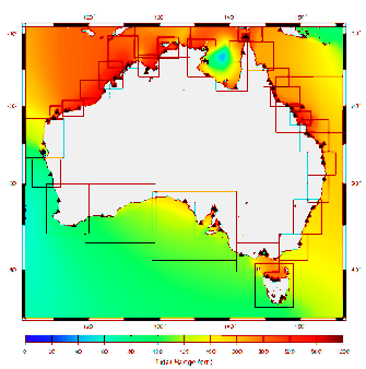
The highest high tide is referred to as the Highest Astronomical Tide (HAT), and is defined as the highest level which can be predicted to occur under average meteorological conditions and any combination of astronomical conditions.
In Australia HAT is calculated as the highest level from tide predictions over the tidal datum epoch (TDE), this is currently set to 1992 to 2011.
The HAT and the Lowest Astronomical Tide (LAT) levels will not be reached every year. LAT and HAT are not the extreme water levels which can be reached, as storm surges may cause considerably
higher and lower levels to occur.
The Highest Astronomical Tide (HAT) has been determined at places where there has been an operational tide gauge at some point in time. Generally HAT is well defined at Standard ports where there is or has been a long term tide gauge.
Queensland HAT
| Site | Highest Astronomical Tide (HAT) | Reference level (datum) |
| Gold Coast Seaway | 1.91 | LAT |
| Brisbane Bar | 2.73 | LAT |
| Mooloolaba | 2.17 | LAT |
| Noosa Head | 2.28 | LAT |
| Waddy Point (Fraser Island) | 2.37 | LAT |
| Urangan | 4.28 | LAT |
| Bundaberg (Burnett Heads) | 3.67 | LAT |
| Gladstone | 4.83 | LAT |
| Port Alma | 5.98 | LAT |
| Rosslyn Bay | 5.14 | LAT |
| Hay Point | 7.14 | LAT |
| Mackay Outer Harbour | 6.58 | LAT |
| Bugatti Reef | 3.50 | LAT |
| Shute Harbour | 4.33 | LAT |
| Bowen | 3.73 | LAT |
| Abbot Point | 3.60 | LAT |
| Cape Ferguson | 3.84 | LAT |
| Townsville | 4.11 | LAT |
| Lucinda (Offshore) | 3.96 | LAT |
| Clump Point | 3.62 | LAT |
| Mourilyan Harbour | 3.50 | LAT |
| Cairns | 3.50 | LAT |
| Port Douglas | 3.36 | LAT |
| Leggatt Island | 3.40 | LAT |
| Thursday Island | 3.86 | LAT |
| Goods Island | 4.07 | LAT |
| Booby Island | 4.31 | LAT |
| Weipa (Humbug Point) | 3.38 | LAT |
| Karumba | 4.88 | LAT |
| Mornington Island | 3.87 | LAT |
Resources:
HAT for Queensland is from: http://www.msq.qld.gov.au/Tides/Tidal-planes © The State of Queensland (Department of Transport and Main Roads) 2016.