
Oceanography of Australia
What is Oceanography?

Oceanography is the study of the composition and motion of the water column and the processes which are responsible for that motion.
The principal oceanographic processes influencing Australia's continental shelf waters include waves and tides as well as wind-driven and other oceanic currents.
Oceans of Australia the island continent
Australia is an island continent. This means that every state (excluding Northern Territory and the ACT) is surrounded by Ocean waters.
To the South but not bordered on the Australian coast is the Southern Ocean, to the West is the Indian Ocean and to the East is the Pacific Ocean.

The Seas of Australia
The coast of Australia is also bordered by several seas. The seas of Australia include the Arafura sea which lies between northern Australia, Papua New Guinea and Timor while the Coral sea lies between the north east coast of Australia, Papua New Guinea and the Solomon Islands. The Tasman sea lies off the south east coast of Australia, between Australia and New Zealand.

The Continental Shelf of Australia
Surrounding Australia is a shallow extension of the landmass known as the continental shelf. This shelf is relatively shallow, up of 200 meters deep compared to the thousands of meters deep in the open ocean, and extends outward to the continental slope where the deep ocean begins.

The Ocean currents of Australia
There are four major ocean currents that operate within Australias surrounding oceans and seas.
These are the Indonesian Throughflow, the Leeuwin current, the Antarctic circumpolar current and the East Australian current.
Click this link for an animation of Australia's major currents (from the CSIRO website).
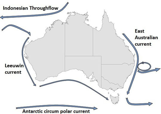
The Indonesian Throughflow
As the name suggests the Indonesian Throughflow is a system of currents that carries water westward from the Pacific to the Indian Ocean through the deep passages and straits of the Indonesian Archipelago.
This is the only place in the world where warm, equatorial waters flow from one ocean to another. This warm tropical water influences the character of the Leeuwin Current.
Click this link for an animation of the Indonesian Throughflow current (from the CSIRO website).
The leeuwin Current
Begins around mid-way along the Western Australian coast and flows down the coast and around the bottom of Western Australia. The Leeuwin Current then flows Eastward across the Great Australian Bight and reaches as far as the west coast of Tasmania as the Zeehan Current.
The East Australian Current
This current moves southward from near Fraser Island in Queensland to the eastern coast of Tasmania.
The East Australian Current is usually stronger in summer, when it reaches further south, often bringing with it northern tropical species such as tuna and even large sea turtles following the current into Bass Strait.
The East Australian Current is a Western Boundary current and is renowned for shedding eddies off the Queensland and New South Wales coasts.
The Antarctic Circumpolar Current
The Antarctic Circumpolar Current moves perpetually eastward chasing and joining itself and at 21,000 km in length, it comprises the world's longest ocean current, carrying an estimated 165 million to 182 million cubic metres of water every second (a unit also called a “Sverdrup”) from west to east, more than 100 times the flow of all the rivers on Earth. transporting 130 million cubic m of water per second (4.6×10⁹ cu ft/s) 100 times the flow of all the world's rivers. It extends from the sea surface to the bottom of the ocean, and encircles Antarctica.
It is vital for Earth’s health because it keeps Antarctica cool and frozen. It is also changing as the world’s climate warms. It provides the main connection between the Indian, Pacific and Atlantic Oceans. The ACC is created by the combined effects of strong westerly winds across the Southern Ocean, and the big change in surface temperatures between the Equator and the poles.
Ocean density increases as water gets colder and as it gets more salty. The warm, salty surface waters of the subtropics are much lighter than the cold, fresher waters close to Antarctica. We can imagine that the depth of constant density levels slopes up towards Antarctica.
Salinity of Australian Waters

Across the north coast of Australia the ocean areas have lower salinity due to fresh water input from high rainfall compared to the ocean areas surrounding most of Australia.
The salinity of the ocean regions south of the tropics and above the Southern Ocean is higher due to high evaporation and low rainfall. Note that theses are the average annual salinity's, and as such, varies over differing time scales from site to site.
The Tides of Australia
Highest Astronomical Tide (HAT)
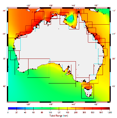
The highest high tide is referred to as the Highest Astronomical Tide (HAT), and is defined as the highest level which can be predicted to occur under average meteorological conditions and any combination of astronomical conditions.
In Australia HAT is calculated as the highest level from tide predictions over the tidal datum epoch (TDE), this is currently set to 1992 to 2011.
The HAT and LAT levels will not be reached every year. LAT and HAT are not the extreme levels which can be reached, as storm surges may cause considerably higher and lower levels to occur.
Resources:
Some ocean currents information on this page has been modified from:
http://www.csiro.au/en/Outcomes/Climate/Understanding/AustralasianOceanCurrents.aspx
Some information on this page has been modified from http://en.wikipedia.org/wiki/Southern_Ocean under a CCPL License 3.0 http://creativecommons.org/licenses/by-sa/3.0/
HAT definition from http://www.msq.qld.gov.au/Tides/Notes-and-definitions.aspx (CCBY)
Marine Science News
Could seaweed help save the planet? Blue carbon solution to be investigated by AIMS
The secret lives of silky sharks: unveiling their whereabouts supports their protection
Is the Great Barrier Reef reviving – or dying? Here’s what’s happening beyond the headlines
New Australian laws for ‘engineering’ the ocean must balance environment protection and responsible research
Keppel corals show resilience following severe bleaching
Marine Science facts
The vampire squid gets its name not because it has a taste for blood but from the dark skin on its arms that makes it look like it’s wearing a Dracula-esque cape?
The oceans provide 99% of the living space on the planet containing 50-80% of all life.
The Oceans cover 70% of the earths suface
The deepest part of the ocean is called the Mariana Trench, which is around 7 miles deep and is located in the South Pacific Ocean.
The water pressure at the bottom of the Mariana Trench is eight tons per square inch. This means the pressure there is enough to crush you.
The largest mountain range is found underwater and is called the Mid-Oceanic Ridge that is around 65,000 kilometres long.
Sponges are older than dinosaurs.
Half the Oxygen we breath is produced in the Ocean.
Irukandji jelly fish, with just a brush of venom leaves almost no mark. But after about a half hour you develop Irukandji syndrome, a debilitating mix of nausea, vomiting, severe pain, difficulty breathing, drenching sweating and sense of impending doom. You get so sick that your biggest worry is that you’re not going to die.
The most remote point in the oceans is called Point Nemo.
The Pacific, Atlantic, and Indian oceans are known as the three major oceans.