
Measuring Sea Level
Why measure sea level?
Sea level is measured for several purposes including:
- For scientific research purposes such as determining sea level (rise) change.
- For the basis of tide predictions. There must be a long term and accurate set of sea level observations to generate accurate and reliable tide predictions.
- For maritime safety purposes, real time sea level measurements are used to calculate under keel clearance for vessel movements.
- Tidal levels (or planes) are calculated from long term sea level measurements and used for coastal development and as reference levels for emergency response in coastal regions.
How is sea level measured?
The problem with measuring sea level is that sea level is changing on several time scales, from the most frequent changes of surface waves to less frequent tidal variations and climate induced changes. The type of instrument used to measure sea level is dependent on the purpose or use of the measurement.
The aim in measuring sea levels is to measure the vertical distance between the average surface of the sea and a fixed datum level.
The level must be averaged to smooth out the influence of wind waves.
There are three main methods of measuring sea level; surface following; fixed sensors or remote and mobile.
Surface following Tide Gauges

Float based tide gauges still form a large part of the global network of tide gauges. The paper charts used to record the level have been made digital with the use of shaft encoders.
Even if they are now being replaced with acoustic, pressure and radar systems, they were the source of most of the historical sea level record.
This type of tide gauge requires a high level of attention due to mechanical parts and the need to change the paper chart regularly.

This analogue tide gauge uses a float to follow the water level. The float is normally attached by cable and pulley to a mechanism that records the smoothed sea level on a paper chart relative to tidal datum. Smoothing of the levels is achieved through placing the float within a stilling well.
This preserved analogue tide gauge is on Raffle Island Light house in Singapore.

Fixed Sensor Tide Gauges
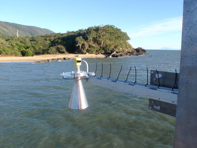
Radar sensor
The most common method for measuring sea level in Australia is with what is called a radar sensor. The radar uses microwave pulses to determine the distance from the sensor to the average water surface.
The antenna system of the radar sensor sends out extremely short microwave pulses that are reflected by the sea surface and received by the antenna system. The time elapsing from emission to reception of the microwave pulses is proportional to the distance from the sensor to average sea level. A special time-stretching procedure makes a certain and exact measurement of the extremely short intervals possible.
Resources:
Marine Science News
Could seaweed help save the planet? Blue carbon solution to be investigated by AIMS
The secret lives of silky sharks: unveiling their whereabouts supports their protection
Is the Great Barrier Reef reviving – or dying? Here’s what’s happening beyond the headlines
New Australian laws for ‘engineering’ the ocean must balance environment protection and responsible research
Keppel corals show resilience following severe bleaching
Marine Science facts
The vampire squid gets its name not because it has a taste for blood but from the dark skin on its arms that makes it look like it’s wearing a Dracula-esque cape?
The oceans provide 99% of the living space on the planet containing 50-80% of all life.
The Oceans cover 70% of the earths suface
The deepest part of the ocean is called the Mariana Trench, which is around 7 miles deep and is located in the South Pacific Ocean.
The water pressure at the bottom of the Mariana Trench is eight tons per square inch. This means the pressure there is enough to crush you.
The largest mountain range is found underwater and is called the Mid-Oceanic Ridge that is around 65,000 kilometres long.
Sponges are older than dinosaurs.
Half the Oxygen we breath is produced in the Ocean.
Irukandji jelly fish, with just a brush of venom leaves almost no mark. But after about a half hour you develop Irukandji syndrome, a debilitating mix of nausea, vomiting, severe pain, difficulty breathing, drenching sweating and sense of impending doom. You get so sick that your biggest worry is that you’re not going to die.
The most remote point in the oceans is called Point Nemo.
The Pacific, Atlantic, and Indian oceans are known as the three major oceans.