
The Tides
What is the Tide?
Tides are represented by the periodic rise and fall of the surface of the oceans, due to the gravitational interactions between the moon, sun and earth. The Moon has a greater effect because, although it is much smaller than the Sun, it is much closer. The Moon’s gravitational pull is about twice that of the Sun.
Tides are essentially long, slow moving waves created by the gravitational pull of the moon, and to a lesser degree, the sun. Tides can be thought of as standing waves.
The action of the tide is generated by these gravitational attraction forces which cause the water in the oceans to be pulled towards a nodal (focal) point directly below the Moon and the Sun.
The Tidal Range
The range of the tide is the difference between the height of high water and the next succeeding or last preceding low water.
The tidal range for any particular site is determined as the difference between the highest high tide and the Lowest Astronomical Tide (LAT) datum.
The highest high tide is referred to as the Highest Astronomical Tide (HAT), and is defined as the highest level which can be predicted to occur under average meteorological conditions and any combination of astronomical conditions.
In Australia HAT is calculated as the highest level from tide predictions over the tidal datum epoch (TDE), this is currently set to 1992 to 2011.
The HAT and LAT levels will not be reached every year. LAT and HAT are not the extreme levels which can be reached, as storm surges may cause considerably higher and lower levels to occur.
Tidal range varies from place to place, in Australia the largest tidal range occurs on the North West Coast where the Highest Astronomical tide (HAT) exceeds 10 metres.
The Spring and Neap tide cycle

The tide cycle can be separated into two general types by the level that is reached at high and low tide.
Spring tides are characterised by higher high tides and lower low tides than the neap tides.
What causes the Spring-Neap cycle?
Together, the gravitational pull of the moon and the sun influence the Earth’s tides.
During full or new moons—which occur when the Earth, sun, and moon are nearly in alignment—average tidal ranges are slightly larger. This occurs twice each month. The moon appears new (dark) when it is directly between the Earth and the sun. The moon appears full when the Earth is between the moon and the sun. In both cases, the gravitational pull of the sun is "added" to the gravitational pull of the moon on Earth, causing the oceans to bulge a bit more than usual. This means that high tides are a little higher and low tides are a little lower than average.
When the sun, moon, and Earth are aligned (at the time of the new or full moon), the solar tide has an additive effect to the lunar tide, creating extra-high high tides, and very low, low tides these are called spring tides. When the sun and moon are at right angles to each other, the solar tide partially cancels out the lunar tide and produces moderate tides known as neap tides.
During each lunar month, two sets of spring and two sets of neap tides occur.
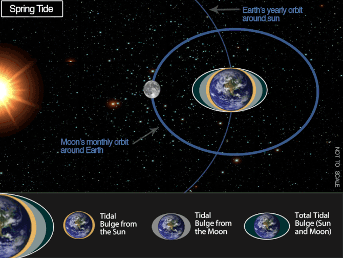
In the above animation the tidal bulge is somewhat exaggerated, on the real earth the oceans are not continuous hence the bulge is irregular in comparison.
Diurnal and semi-diurnal tides
All tides are composed of both diurnal (once a day) and semi-diurnal (twice a day) components.
Diurnal tides
A diurnal tide is characterised by one high water (tide) and one low water (tide) per day. Typically with a diurnal tide each successive high or low tide is 24 hours and 50 minutes apart, this is the length of one lunar day.

Semi-Diurnal tides
A semi-diurnal tide occurs generally when there are two high waters (tides) and two low waters (tides) per day. Typically the time between each successive high or low tide is 12 hours 25 minutes, this is half of one lunar day.

Mixed tides
The most common type of tidal signal is a mixture of both diurnal and semi-diurnal signals this creates a mixed tide.
Tidal Currents
Tidal currents are the alternating horizontal movement of water associated with the rise and fall of the tide.
Tidal currents are caused by gravitational interactions between the Sun, Moon, and Earth.
Tidal currents are periodic with a net velocity of zero over the particular tidal cycle.
In the deep open ocean maximum tidal currents tend to parallel the high tide and minimum current speeds are associated with low tide. When the tide wave enters shallow coastal waters friction with the bottom slows the current and the maximum is then delayed to be mid way between the low and high tide.
When the tide is rising and the flow of the current is directed towards the shore, the tidal current is called the flood (tide) current, and when the tide is receding, it is called the ebb (tide) current.
King Tides
King tide is a popular term for an especially high tide, such as a perigean spring tide. King tide is not defined in scientific terms, nor is it used in a scientific context. Use of the term ‘king tide’ originated in Australia, New Zealand and other Pacific nations to refer to an especially high tide that occurs only a few times per year. The term has now come to be used in British Columbia and the United States as well.
In Queensland the term King tide refers to the highest tide in any one year. The term has in recent times been extended, particularly by media sources, to include any particularly high tide. A King tide refers to the tide level only and as such anomalies in sea level due to non-tidal factors are not defined as King tides.
What causes a King tide?
In a lunar month the highest tides occur at the time of the new moon and full moon, when the gravitational forces of the sun and moon are in line. These are called spring tides and they occur about every 14 days.
In any one year there will be two spring tides that are the highest, one during summer the other during winter. These are often referred to as king tides. The king tides occur because of the combined influence of a number of astronomical factors related to the Sun and the Moon, and their alignments relative to the Earth.
The earth moves around the sun in an ellieptical orbit that takes a little over 365 days to complete. The sun has an influence on the tides. The sun's gravitational force is greatest when the earth is closest to the sun called perihelion (and in summer in Australia) and least when the sun is furthest from earth called aphelion (in Australias winter).
The moon has a larger influence on tide levels than the sun. The moon orbits the earth in an elliptical fashion taking around 29 days to complete. The gravitational force of the moon at the earths surface is greatest when the moon is closest to the earth called perigee and least when the moon is furthest from the earth called apogee around two weeks after perigee.
The king tides occur when the earth, moon and sun are aligned at perigee and perihelion. The combined effect of the moon's phase and the varying gravitational forces of the sun and moon result in the highest of the spring tides occurring during the summer months of December, January and February in Australia and also in the winter months of June, July and August.
During normal weather conditions, the height of the king tides will be similar from year to year. However in abnormal weather conditions (severe storms or cyclones) the low air pressures and strong winds at these times can elevate the sea level above the expected height.
The Dodge tide
During neap tides there is often very little movement of water at specific locations. These breaks in tidal movement can last up to 24 hours with little or no water movement.
This phenomenon has been described by Chapman (1936) in the Official Yearbook of the Commonwealth of Australia of 1938. It was Captain Matthew Flinders that named the effect “The Dodger” (after the artful dodger) due to the apparent impossibility of saying when the tide will be at this particular period.
While dodge tides occur in a number of locations worldwide and in Australia, the term 'dodge' is used only in South Australia. The dodge tide is seen in Gulf St Vincent (in South Australia), where the amplitudes of the main semi-diurnal tide constituents are almost identical. At neap tides the semi-diurnal tide is virtually absent, resulting in an extended period of slack water occurring twice a month. This effect is accentuated near the equinoxes when the diurnal component also vanishes, resulting in periods of slack water.
Other places in Australia where the dodge tide effect is evident include: Groote Eylandt in the Northern Territory, Portland in Victoria and Cape Ferguson in Queensland.
Tide Predictions
Tide predictions are generated via a mathematical process by which the times and heights of the tides are determined in advance from the harmonic constituents at a place. The tide predictions can also be referred to as "tide tables, tide times, tides, tide predictions or tide charts".
How are tide predictions generated?
The tide prediction method used today in Australia is called harmonic analysis. The ideal tide curve for any given port is represented as an average height Z0 plus a sum of terms (constituents) each of which is of the form f(t) = H cos(at + \phi).
The time t is measured in hours, and f comes out in metres. The numbers H,a,\phi are the amplitude, the speed and the phase of the constituent. The speed is given in degrees/hour, and the phase in degrees. Different constituents have different speeds, which are sums and differences of small integral multiples of 5 basic astronomical speeds.
Resources:
Information on: "Tidal Range" has been modified from: http://www.msq.qld.gov.au/Tides/Notes-and-definitions.aspx, © The State of Queensland (Department of Transport and Main Roads) 2009.
"King tide" and "What causes a King tide" has been modified from :http://www.msq.qld.gov.au/Tides/King-tides.aspx, © The State of Queensland (Department of Transport and Main Roads) 2010–2014.
Dodge tide information modified from: http://en.wikipedia.org/wiki/Slack_water#Dodge_tides
Marine Science News
Jaws at 50: how a single movie changed our perception of white sharks forever
Shark Defence Campaign. Sea Shephard have a new campaign
Marine Worm Offers Clues About Our Evolutionary Past
Offshore oil and gas infrastructure brings localised, but limited regional benefits for marine organisms
World-first initiative Guardian of the Great Barrier Reef
Marine Science facts
The vampire squid gets its name not because it has a taste for blood but from the dark skin on its arms that makes it look like it’s wearing a Dracula-esque cape?
The oceans provide 99% of the living space on the planet containing 50-80% of all life.
The Oceans cover 70% of the earths suface
The deepest part of the ocean is called the Mariana Trench, which is around 7 miles deep and is located in the South Pacific Ocean.
The water pressure at the bottom of the Mariana Trench is eight tons per square inch. This means the pressure there is enough to crush you.
The largest mountain range is found underwater and is called the Mid-Oceanic Ridge that is around 65,000 kilometres long.
Sponges are older than dinosaurs.
Half the Oxygen we breath is produced in the Ocean.
Irukandji jelly fish, with just a brush of venom leaves almost no mark. But after about a half hour you develop Irukandji syndrome, a debilitating mix of nausea, vomiting, severe pain, difficulty breathing, drenching sweating and sense of impending doom. You get so sick that your biggest worry is that you’re not going to die.
The most remote point in the oceans is called Point Nemo.
The Pacific, Atlantic, and Indian oceans are known as the three major oceans.