
Ocean Currents
Generally speaking currents are a horizontal movement of water. Ocean currents may be classified as tidal and non-tidal.
Non-tidal currents include the permanent currents in the general circulatory systems of the sea as well as temporary currents arising from more pronounced meteorological variability.
Non-Tidal Currents - Coastal currents
Coastal currents are intricately tied to winds, waves, and land formations. Winds that blow along the shoreline, longshore winds,affect waves and, therefore, currents.
Longshore Currents
As a wave moves toward the beach, different segments of the wave encounter the beach before others, which slows these segments down. As a result, the wave tends to bend and conform to the general shape of the coastline. Waves do not typically reach the beach perfectly parallel to the shoreline, rather, they arrive at a slight angle. When a wave reaches a beach or coastline, it releases a burst of energy that generates a current, which runs parallel to the shoreline. This type of current is called a "longshore current".
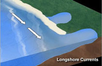
Longshore currents are affected by the velocity and angle of a wave. When a wave breaks at a more acute (steep) angle on a beach, encounters a steeper beach slope, or is very high, longshore currents increase in velocity. Conversely, a wider breaking angle, gentler beach slope, and lower wave height slows a longshore current’s velocity. In either case, the water in a longshore current flows up onto the beach, and back into the ocean, as it moves in a “sheet” formation.
As this sheet of water moves on and off the beach, it can “capture” and transport beach sediment back out to sea. This process, known as “longshore drift,” can cause significant beach erosion.
Rip Currents
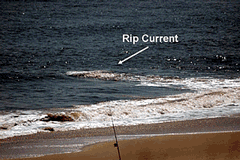
When waves travel from deep to shallow water, they break near the shoreline and generate currents. A rip current forms when a narrow, fast-moving section of water travels in an offshore direction.
As longshore currents move on and off the beach, "rip currents" may form around low spots or breaks in sandbars, and also near structures such as jetties and piers.
A rip current is a localized current that flows away from the shoreline toward the ocean, perpendicular or at an acute angle to the shoreline. It usually breaks up not far from shore and is generally not more than 25 meters wide.
If wave activity is slight, several low rip currents can form, in various sizes and velocities. But in heavier wave action, fewer, more concentrated rip currents can form.
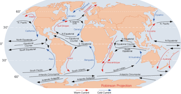
Boundary Currents
Global winds drag on the water’s surface, causing it to move and build up in the direction that the wind is blowing. And just as the Coriolis effect deflects winds to the right in the Northern Hemisphere and to the left in the Southern Hemisphere, it also results in the deflection of major surface ocean currents to the right in the Northern Hemisphere (in a clockwise spiral) and to the left in the Southern Hemisphere (in a counter-clockwise spiral). These major spirals of ocean-circling currents are called “gyres” and occur north and south of the equator. They do not occur at the equator, where the Coriolis effect is not present (Ross, 1995).
Boundary currents are Ocean currents with dynamics determined by the presence of a coastline.
They fall into two categories: 1) western boundary currents, which are narrow, deep-reaching, and fast-flowing currents, not unlike jet streams, associated with current instability and eddy shedding; and 2) eastern boundary currents, which are shallow, cover a wider region, are of moderate strength, and are often associated with coastal upwelling and a subsurface counter-current along the continental slope.
Both are integral parts of the circulation in oceanic gyres. The rotation of the earth causes an accumulation of energy on the western side, which has to be dissipated in boundary currents; this gives the western boundary currents typical widths of 100 km and typical speeds of 2 m s-1 and causes them to shed eddies frequently to increase the dissipation of energy. No similar requirement of energy dissipation exists on the eastern side, so eastern boundary currents can be broad and slow. Their special character as a boundary current results from coastal upwelling, which brings the thermocline to the surface and as a result produces a temperature front and an associated geostrophic maximum in the current speed, known as the coastal jet. Because of the upwelling, eastern boundary currents are atmospheric heat sinks (AMS Glossary).
Western boundary currents are atmospheric heat sinks if they move cold water toward the equator, which occurs in the subpolar gyres, and atmospheric heat sources where they move tropical water into temperate regions, as in the subtropical gyres. As the name suggests boundary currents flow along the boundaries of ocean basins.
The East Australia current (EAC) is a Western Boundary current that flows southward along the east coast of Australia. The EAC is measured off Stradbroke Island in Queensland by a new type of waverider buoy capable of measuring currents as well as waves.
Eastern boundary currents are shallow and cover a wider region and are of moderate strength. they are often associated with coastal upwelling and a subsurface counter-current along the continental slope.
What is a Gyre?
A gyre is a large-scale system of wind-driven surface currents in the ocean. The five major Gyres are located in the North and South Pacific, the North and South Atlantic, and the Indian Ocean — which are massive, circular current systems. The accumulation zones of plastic that form in the five subtropical gyres are a result of the diminished winds and currents occurring at latitudes synonymous with continental deserts. Basically, plastic is trapped within these currents, taking at least 10 years to cycle back out — if it doesn’t first get eaten by marine life or sink to the bottom.
Equatorial Currents
Trade winds that prevail over the tropical oceans drive complex oceanic circulations, these are characterized by alternating eastward and westward currents. that are confined to the surface layers of the ocean.
Polar Currents
The Antarctic circum polar current is the only current that flows completely around the globe, it is also the strongest of all ocean currents.
Tidal Currents
Tides create a current in the oceans, near the shore, and in bays and estuaries along the coast. These are called "tidal currents." Tidal currents are the only type of currents that change in a very regular pattern and can be predicted for future dates. Tidal currents are caused by gravitational attraction of the Moon (the lunar tide) and the Sun (the solar tide) and the gravitational force of the Earth.
Tidal currents are the alternating horizontal movement of water associated with the rise and fall of the tide. When the tide is rising and the flow of the current is directed towards the shore, the tidal current is called the flood (tide) current, and when the tide is receding, it is called the ebb (tide) current.
Tidal Currents in the deep open Ocean
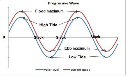
In the deep open ocean maximum tidal currents tend to parallel high water and low water, with slack water occurring somewhere between high and low tides.
Slack water occurs at times of little or no water movement.
This wave form is called a progressive wave.
Tidal Currents in Coastal Regions

When the tide wave enters shallow coastal waters, friction with the bottom slows the current, and the maximum current speed is then delayed to be mid way between low and high waters.
Tidal currents vary
Tidal currents are affected by the relative positions of the moon and Earth. When the moon and Earth are positioned nearest to each other (perigee), the currents are stronger than average and are called “perigean currents.” When the moon and Earth are at their farthest distance from each other (apogee), the currents are weaker and are called “apogean currents.”
Tidal currents, just like tides, are affected by the different phases of the moon. When the moon is at full or new phases, tidal current velocities are strong and are called “spring currents.” When the moon is at first or third quarter phases, tidal current velocities are weak and are called “neap currents.”
Reference
AMS Glossary, http://glossary.ametsoc.org/wiki/Boundary_currents
Ross, D. 1995 Introduction to Oceanography. New York: HarperCollins College Publishers. pp. 199-226, 339-343.
Marine Science News
When a beach walk feels like grief: disasters like SA’s algal bloom cut us off from nature when we need it most
As oceans warm, tropical fish are moving south. New friendships may be helping them survive
Jaws at 50: how a single movie changed our perception of white sharks forever
The ocean can look deceptively calm – until it isn’t. Here’s what ‘hazardous surf’ really means
Marine Science facts
The vampire squid gets its name not because it has a taste for blood but from the dark skin on its arms that makes it look like it’s wearing a Dracula-esque cape?
The oceans provide 99% of the living space on the planet containing 50-80% of all life.
The Oceans cover 70% of the earths suface
The deepest part of the ocean is called the Mariana Trench, which is around 7 miles deep and is located in the South Pacific Ocean.
The water pressure at the bottom of the Mariana Trench is eight tons per square inch. This means the pressure there is enough to crush you.
The largest mountain range is found underwater and is called the Mid-Oceanic Ridge that is around 65,000 kilometres long.
Sponges are older than dinosaurs.
Half the Oxygen we breath is produced in the Ocean.
Irukandji jelly fish, with just a brush of venom leaves almost no mark. But after about a half hour you develop Irukandji syndrome, a debilitating mix of nausea, vomiting, severe pain, difficulty breathing, drenching sweating and sense of impending doom. You get so sick that your biggest worry is that you’re not going to die.
The most remote point in the oceans is called Point Nemo.
The Pacific, Atlantic, and Indian oceans are known as the three major oceans.