
Waves
Wave height
Waves are classified by amplitude, period and wavelength.
The amplitude of an ocean wave is the wave height from trough to crest divided by 2.
Wave period is the time it takes for a wave to pass between successive crests.
Wave height reported by a Wave rider buoy is called "significant wave height" or Hsig.
Hsig is the height of the largest 1/3 of waves in a 30 minute record measured as the vertical distance between the crest of a wave and the following trough.

Ocean Waves
Most ocean waves are seen as a disturbance of the water surface.
Water in the upper layers of the oceans is in constant motion, produced primarily by the action of winds blowing across the surface. The effect of the interaction between winds and the sea surface results in waves and currents.
Ocean waves vary in size from ripples at the millimetre scale to storm waves as high as 30 metres.

How are ocean waves measured?
Wave rider Buoys
Waves around the Australian coastline are measured by Wave rider (Waverider is the manufactures name) buoys. Each Wave rider buoy is anchored to the sea floor. The buoys are specially designed to follow the movement of the ocean surface.
The anchoring system includes a length of rubber chord that is capable of stretching up to three times its length.
This flexibility of the mooring allows the Wave rider to more truly follow the fluctuating ocean surface.
Fluctuations in the ocean surface are measured by either an accelerometer mounted inside the Wave rider buoy or a GPS unit and converted to radio signals that are transmitted to a receiver station on shore.
The electronics and the navigation light are powered for up to twelve months by a bank of dry cell batteries mounted around the inside of the hull.

Wave rider Accelerometer Buoys
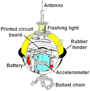
Fluctuations in the ocean surface are measured by an accelerometer mounted inside the Wave rider buoy and converted to radio signals that are transmitted to a receiver station on shore.
The electronics and the navigation light are powered for up to twelve months by a bank of dry cell batteries mounted around the inside of the hull.
The accelerometer is mounted on a horizontal, stabilised platform suspended in a fluid filled sphere in the bottom of the Wave rider buoy. The accelerometer is designed to measure the heave (the up-and-down motions) of the Waverider buoy as it follows the movement of the ocean surface.
Electronic circuitry on the Wave rider buoy converts heave into displacements (up and down) representing the amount of vertical movement it experienced.
Directional Wave rider buoys also have an additional two fixed accelerometers to measure accelerations in the north-south and east-west axes. This information is combined with the heave to resolve wave directions.
Waverider GPS Buoys

This buoy uses the global positioning system (GPS) to determine wave heights and wave directions without the use of an accelerometer.
Using changes in the frequency of satellite signals received by a buoy as it moves, the on-board software can accurately and quickly calculate how it is moving.
The global positioning system (GPS) receiver inside a wave buoy is similar to the technology used in car navigation systems, with some additional smart processing capabilities.
A GPS buoy receives a signal from several satellites orbiting the earth and uses these signals to obtain an absolute position on the earth’s surface. Once a buoy has found its initial position, it can then measure relative (local) movement using the GPS Doppler principle.
How GPS works
A GPS satellite sends a fixed frequency signal to all GPS devices including buoys. If the buoy moves towards the satellite, the signal will be compacted. The signal is received at a high frequency or faster than expected. If the buoy moves away from the satellite, the signal is expanded and will be received at a lower frequency, or slower than expected.
This is similar to the way sound waves compress if an ambulance is headed towards you making the siren sound louder and at a higher pitch. When the ambulance is headed away, the sound waves expand with the movement of the ambulance and the siren sounds quieter and at a lower pitch.
Using these changes in the frequency of satellite signals received by a buoy as it moves, the on-board software can accurately and quickly calculate how it is moving.
By monitoring its relative movement using several satellites, the buoy is able to separate its movement into both height and direction with a high degree of accuracy.
Tsunami Waves
Tsunamis are long-wavelength shock waves generated by sudden changes in sea floor in coastal areas. This occurs as the result of earthquakes, landslides as landslides into the ocean or submarine slumps and volcanic eruptions.
A tsunami is a series of ocean waves that sends surges of water, sometimes reaching heights of over 30 meters, onto land. These walls of water can cause widespread destruction when they crash ashore. These awe-inspiring waves are typically caused by large, undersea earthquakes at tectonic plate boundaries. When the ocean floor at a plate boundary rises or falls suddenly it displaces the water above it and launches the rolling waves that will become a tsunami.
Tsunami's have very long wave lengths, in the order of hundreds of kilometres in length. In the Pacific ocean, where the depth is around 4300 m a tsunami can travel at 800 km/h, a phenomenal speed, almost as fast as the cruising speed of a jumbo jet (893 km/h).
A tsunami’s trough, the low point beneath the wave’s crest, often reaches shore first. When it does, it produces a vacuum effect that sucks coastal water seaward and exposes harbor and sea floors. This retreating of sea water is an important warning sign of a tsunami, because the wave’s crest and its enormous volume of water typically hit shore five minutes or so later.
![2004 Indonesia Tsunami. By Animation fournie par Vasily V. Titov, Sous-directeur du Service de Cartographie des Raz de marée et Inondations du NOAA, aux (NOAA) [Public domain], via Wikimedia Commons](https://image.jimcdn.com/app/cms/image/transf/none/path/s6ecaf51f4042b407/image/i6e6f55c1a8d3f003/version/1348747415/2004-indonesia-tsunami-by-animation-fournie-par-vasily-v-titov-sous-directeur-du-service-de-cartographie-des-raz-de-mar%C3%A9e-et-inondations-du-noaa-aux-noaa-public-domain-via-wikimedia-commons.gif)
Read about Meteorological Tsunami
Tide Waves
Tides are a very long-period wave that moves through the oceans in response to the gravitational forces exerted by the moon and sun. Tides originate in the oceans and progress toward the coastlines where they appear as the regular rise and fall of the sea surface.
When the highest part, or crest of the wave reaches a particular location, high tide occurs.
When the lowest part of the wave or its trough reaches the coast, low tide occurs.
Although tsunamis have been referred to as "Tidal waves" in the past. Tide waves are in no way related to tsunamis. Tide waves have an entirely different origin to tsunami and are truly everyday events, whereas tsunamis are relatively rare events.
Tidal Bores
The interaction of the leading edge of the incoming tide with the outgoing current from a river can sometimes produce a solitary wave that proceeds up the river from its mouth.
Bores occur in relatively few locations worldwide, usually in areas with a large tidal range between high and low water and where incoming tides are funneled into a shallow, narrowing river or lake via a broad bay.
A tidal bore is a surge of water propagating upstream as the tidal flow turns to rising and the flood tide rushes into a funnel shaped river mouth with shallow waters. The bore forms during the spring tides when the tidal range exceeds 4 to 6 m and the estuary bathymetry amplifies the tidal range with a low freshwater level.
It is estimated worldwide that over 400 estuaries are affected by a tidal bore, on all continents but Antarctica. A bore is a discontinuity of the water depth and it represents a hydrodynamic shock.


Planetary Waves
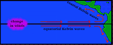
Planetary waves cross the oceans along parallels and interact with general oceanic circulation.
These are either Rossby waves, which go from East to West or Kelvin waves which move in the opposite direction. They may be reflected off the continents and return in the opposite direction, or follow coastlines. These waves and their reflections play a key role in the El Niño phenomenon.
There are two types of Kelvin waves, coastal and equatorial, they are both gravity driven and non-dispersive.
There are two types of Kelvin waves, coastal and equatorial, they are both gravity driven and non-dispersive.
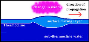
They are often excited by an an abrupt change in the overlying wind field, such as the shift in the trade winds at the start of El Niño.
Reference:
Tidal Bore information and images modified from: Chanson H., 2009. environmental, ecological and cultural impacts of tidal bores. IWEH. International Workshop on Environmental Hydraulics Theoretical, Experimental and Computational Solutions, Valencia, 2009.
Waverider buoy information from: www.qld.gov.au/waves. Glossary and About wave monitoring.
Marine Science News
The secret lives of silky sharks: unveiling their whereabouts supports their protection
Is the Great Barrier Reef reviving – or dying? Here’s what’s happening beyond the headlines
New Australian laws for ‘engineering’ the ocean must balance environment protection and responsible research
Keppel corals show resilience following severe bleaching
New insights into coral symbiosis after bleaching
Marine Science facts
The vampire squid gets its name not because it has a taste for blood but from the dark skin on its arms that makes it look like it’s wearing a Dracula-esque cape?
The oceans provide 99% of the living space on the planet containing 50-80% of all life.
The Oceans cover 70% of the earths suface
The deepest part of the ocean is called the Mariana Trench, which is around 7 miles deep and is located in the South Pacific Ocean.
The water pressure at the bottom of the Mariana Trench is eight tons per square inch. This means the pressure there is enough to crush you.
The largest mountain range is found underwater and is called the Mid-Oceanic Ridge that is around 65,000 kilometres long.
Sponges are older than dinosaurs.
Half the Oxygen we breath is produced in the Ocean.
Irukandji jelly fish, with just a brush of venom leaves almost no mark. But after about a half hour you develop Irukandji syndrome, a debilitating mix of nausea, vomiting, severe pain, difficulty breathing, drenching sweating and sense of impending doom. You get so sick that your biggest worry is that you’re not going to die.
The most remote point in the oceans is called Point Nemo.
The Pacific, Atlantic, and Indian oceans are known as the three major oceans.